Mastic, New York facts for kids
Quick facts for kids
Mastic, New York
|
|
|---|---|
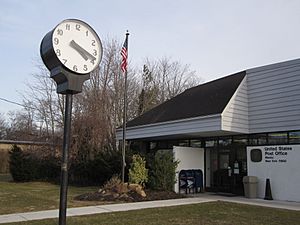
Street clock in front of the Mastic Post Office on Montauk Highway
|
|
 |
|
| Country | United States |
| State | New York |
| County | Suffolk |
| Area | |
| • Total | 3.95 sq mi (10.22 km2) |
| • Land | 3.86 sq mi (10.00 km2) |
| • Water | 0.09 sq mi (0.22 km2) |
| Elevation | 30 ft (9 m) |
| Population
(2020)
|
|
| • Total | 15,404 |
| • Density | 3,989.64/sq mi (1,540.59/km2) |
| Time zone | UTC−05:00 (Eastern Time Zone) |
| • Summer (DST) | UTC−04:00 |
| ZIP Code |
11950
|
| Area code(s) | 631, 934 |
| FIPS code | 36-46074 |
| GNIS feature ID | 0970339 |
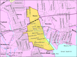
Mastic is a community located in Suffolk County, New York. It is known as a hamlet and a census-designated place (CDP). This means it's a small area that the government counts for population. Mastic is in the southeastern part of the town of Brookhaven. In 2020, about 15,404 people lived here.
Mastic used to be called Forge until 1893. That's when its name changed to Mastic. A train station was built here in 1882. Later, in 1960, the station moved a bit and was renamed Mastic–Shirley.
The Poospatuck Indian Reservation, a special area for Native Americans, is located within Mastic. It's near the southern part of the community, along the Forge River.
The northernmost part of Mastic is called Manor Park. This area stretches from Sunrise Highway to Moriches-Middle Island Road. It is just east of Brookhaven Airport. Some of Manor Park is in the nearby community of Shirley. However, it uses Mastic's zip code, which is 11950.
Contents
Discovering Mastic's Geography
Mastic covers a total area of about 3.95 square miles (10.22 square kilometers). Most of this area is land, about 3.86 square miles (10.00 square kilometers). A small part, about 0.09 square miles (0.22 square kilometers), is water.
Mastic's Population and People
| Historical population | |||
|---|---|---|---|
| Census | Pop. | %± | |
| 2020 | 15,404 | — | |
| U.S. Decennial Census | |||
In 2010, there were 15,481 people living in Mastic. There were 4,526 households, which are groups of people living together. The community had a mix of different backgrounds. About 46.1% of the people were White, and 22.4% were African American. About 21.8% of the people were Hispanic or Latino.
Many households in Mastic had children under 18 years old. About 57.7% of households were married couples living together. The average household had about 3.41 people.
The median age of people in Mastic was 33.1 years old. This means half the people were younger than 33.1, and half were older.
Education in Mastic
Most students in Mastic attend schools in the William Floyd School District. However, some students in the Manor Park section, north of Grove Drive, go to schools in the Eastport-South Manor Central School District.
Local News and Media
- Tri Hamlet News is a local newspaper that covers news for Mastic and nearby communities.
See Also
 In Spanish: Mastic (Nueva York) para niños
 | Stephanie Wilson |
 | Charles Bolden |
 | Ronald McNair |
 | Frederick D. Gregory |


