Forge River (New York) facts for kids
Quick facts for kids Forge River |
|
|---|---|
 |
|
| Country | United States of America |
| Region | Mastic and Moriches, New York |
| Physical characteristics | |
| Main source | Moriches Bay |
| River mouth | 40°46′38″N 72°48′39″W / 40.77722°N 72.81083°W |
| Length | 3.2 nmi (5.9 km) |
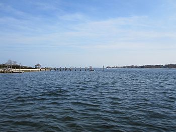
The Forge River is a special kind of river mouth, called an estuary, located on the south shore of Long Island in Brookhaven, New York. Here, fresh water from the land mixes with salty ocean water.
Contents
Journey of the Forge River
The Forge River, once known as the Wegonthotak River, is the main river flowing into Moriches Bay. This bay is part of Long Island's south shore bay system, which is protected from the Atlantic Ocean by sandy barrier islands.
The river actually flows through an old stream bed. This bed was formed by melting ice from a huge glacier about 20,000 years ago. As the ocean levels rose over time, this stream valley filled with water, creating the river we see today.
How the River Flows
The water in the Forge River moves in a complex way. It's affected by the ocean's tides, the different amounts of salt in the water, and even the wind. Water also flows into the river from underground sources and smaller streams.
The part of the river affected by tides is about 3.2 nautical miles long. It stops suddenly at Montauk Highway, which acts like a dam. This dam separates the river towns of Mastic and Moriches.
Two freshwater ponds, East Mill Pond and West Mill Pond, constantly send water into the tidal part of the Forge River at this spot. The total land area that drains into the river is about 43 square kilometers (10,641 acres).
River Depths and Channels
The Forge River has always been quite shallow. Historically, the middle of the river was about 4 to 4.5 feet deep during low tide. Recent surveys show it's now a bit deeper in some places, around 4.9 to 6.6 feet.
A channel about 70 meters (75 yards) wide has been dug to a depth of 2.1 meters (7 feet). This helps boats move through the river more easily.
Several smaller streams, called tributaries, flow into the Forge River. These include Wills Creek, Poospatuck Creek, Lons Creek, and Home Creek on the west side. These creeks have also been dredged, meaning they've been made deeper, up to about 6.6 feet.
However, mounds of sand have built up at the mouths of these creeks. This makes each creek act like a small, separate pool where water doesn't move around much. The same thing happens with Old Neck Creek on the east side of the river.
Wildlife and Habitats
The land around the William Floyd Estate near the river is a great home for many animals. It's a place where American woodcock birds can breed. Many other songbirds also visit or nest here.
The nearby tidal areas are perfect for nesting American bitterns, seaside sparrows, and ospreys. This area is one of the few places left on the south shore of Long Island where wetlands (swampy areas) are right next to undeveloped land. This provides a safe and natural space for wildlife.
History of Duck Farming
For many years, the health of Moriches Bay was harmed by the large number of duck farms along the Forge River and its smaller streams. Studies done between 1950 and 1959 showed that these duck farms were a major source of pollution in the bay.
One way scientists knew the duck farms were causing pollution was by finding unusually high amounts of phosphorus in the water near the farms. This phosphorus came from the ducks.
The last of these farms, the Jurgielewicz Duck Farm, closed in August 2011. It had been open since 1919. At its busiest, this 65-acre farm was known as America's largest free-range duck operation. It raised about 1 million Pekin ducks each year.
 | Jessica Watkins |
 | Robert Henry Lawrence Jr. |
 | Mae Jemison |
 | Sian Proctor |
 | Guion Bluford |

