Outer Barrier facts for kids
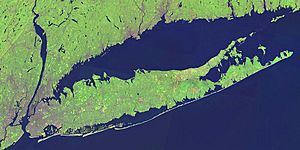
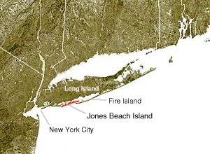
The Outer Barrier is a cool chain of barrier islands that act like a natural shield for Long Island, New York from the big waves of the Atlantic Ocean. These islands include places like Long Beach Barrier Island, Jones Beach Island, and Fire Island. They stretch for about 75 miles (120 km) along the southern coast of Long Island, all the way from Rockaway Peninsula in New York City to Shinnecock Bay in Suffolk County.
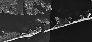
Behind these barrier islands are many calm water areas called lagoons, such as Great South Bay and Moriches Bay. These lagoons are great for boating and other water sports. The barrier islands are broken up by several inlets, which are narrow channels connecting the bays to the ocean. Popular spots like Atlantic Beach, Long Beach, Westhampton Beach, and Jones Beach State Park are found here. Because these islands are low, they can be affected by strong waves and storms, sometimes even getting cut through by the water.
Contents
Exploring the Barrier Islands
New York City's Former Islands
Long ago, some of the westernmost barrier islands were places like Coney Island and Barren Island. Over time, in the early 1900s, most of these islands were connected to the main part of Long Island or joined together. This changed how the coastline looked in New York City.
Long Beach Barrier Island: A Coastal Gem
Long Beach Barrier Island is located off the southern coast of Long Island. This island is home to several communities. These include Atlantic Beach on the west, the city of Long Beach and Lido Beach in the middle, and Point Lookout on the eastern end.
The city of Long Beach stretches across the island, with water on both sides. To the north is Reynolds Channel, and to the south is the Atlantic Ocean. Bridges connect the island to the mainland. The Long Beach Bridge links it to Island Park, and the Atlantic Beach Bridge connects it to Lawrence. The Loop Parkway on the eastern side connects the island to Jones Beach State Park.
Jones Beach Island: Home of Fun in the Sun
Jones Beach Island is another important barrier island off the southern coast of Long Island. It's named after a historian named Thomas Jones. This island is separated from Long Island by the Great South Bay. It crosses the border between Nassau and Suffolk counties.
The southern side of the island is famous for its beautiful beaches facing the Atlantic Ocean. Jones Beach State Park, located on the western tip, is a super popular place for summer fun for people from the New York City area.
You can get to Jones Beach Island from Long Island using several parkways. The Meadowbrook Parkway, Loop Parkway, and Wantagh Parkway all lead there. The eastern end of the island is connected to Babylon, New York, and also to Fire Island by the Robert Moses Causeway. The Ocean Parkway runs along the entire length of the island, connecting all these roads.
Fire Island: A Unique Natural Escape
Fire Island is a long, narrow barrier island, about 31 miles (50 km) long. It's usually between 0.1 and 0.25 miles (160 to 400 meters) wide. It's located southeast of Long Island, separated by the Great South Bay. While only a few hundred people live there year-round, hundreds of thousands visit in the summer!
Fire Island has several communities along the oceanfront, like Davis Park and Watch Hill. Many of these can be reached by private boat or by seasonal ferry service from Long Island. There are also two small villages on the island: Saltaire and Ocean Beach.
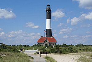
Fire Island Inlet is a channel that connects the Great South Bay to the Atlantic Ocean. It's located between Robert Moses State Park on the western end of Fire Island and Captree State Park on the eastern end of Jones Island. The inlet has changed over many years due to natural forces. For example, the Fire Island Lighthouse was built in 1858 right at the mouth of the inlet, but now it's six miles east of it!
Westhampton Island: The Easternmost Barrier
Westhampton Island is the barrier island furthest to the east in the Town of Southampton. This island used to be part of Fire Island. But in 1931, a big storm called a nor'easter created Moriches Inlet, which made Fire Island a separate island. Then, in 1938, the Great Hurricane of 1938 created Shinnecock Inlet, forming Westhampton Island as a fourth barrier island. Cupsogue Beach County Park is a popular spot on the western end of this island.
Moriches Inlet connects Moriches Bay to the Atlantic Ocean. This inlet created a unique situation where a part of the Town of Brookhaven is actually west of West Hampton Dunes, even though it's a long drive to get there from the main part of Brookhaven.
Shinnecock Inlet is the easternmost of the five main inlets that connect the bays to the Atlantic Ocean. These inlets cut through the narrow barrier islands that stretch for 100 miles along Long Island's south shore. The Shinnecock Inlet is very important for boaters because it lines up almost perfectly with the Shinnecock Canal. This saves boats many miles when they want to go from the bays to the open Atlantic Ocean. Because of this, efforts are made to keep the inlet clear and open. However, maintaining the inlet has caused some debate because it can lead to beach erosion on Fire Island.
 | Jessica Watkins |
 | Robert Henry Lawrence Jr. |
 | Mae Jemison |
 | Sian Proctor |
 | Guion Bluford |


