Long Beach, New York facts for kids
Quick facts for kids
Long Beach, New York
|
|||
|---|---|---|---|
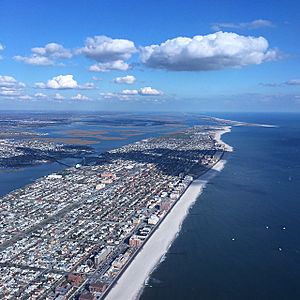
Aerial photograph of Long Beach, NY and environs from west-by-southwest
|
|||
|
|||
| Nickname(s):
The City by the Sea
|
|||
| Motto(s):
Civitas ad mare
(City by the Sea) |
|||
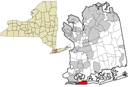
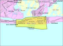
Location in Nassau County and the state of New York
|
|||
| Country | |||
| State | |||
| County | Nassau | ||
| Settled | 1623 | ||
| Incorporated Village | 1913 | ||
| City of Long Beach | 1922 | ||
| Founded by | William H. Reynolds | ||
| Government | |||
| • Type | Council-Manager | ||
| Area | |||
| • Total | 3.90 sq mi (10.09 km2) | ||
| • Land | 2.22 sq mi (5.74 km2) | ||
| • Water | 1.68 sq mi (4.34 km2) | ||
| Elevation | 0 ft (0 m) | ||
| Population
(2020)
|
|||
| • Total | 35,029 | ||
| • Density | 15,793.06/sq mi (6,098.69/km2) | ||
| 34th densest in US | |||
| Time zone | UTC-5 (EST) | ||
| • Summer (DST) | UTC-4 (EDT) | ||
| ZIP code |
11561
|
||
| Area codes | 516, 363 | ||
| FIPS code | 36-43335 | ||
| GNIS feature ID | 0955835 | ||
Long Beach is a city right on the ocean in Nassau County, New York. It's located on the Long Beach Barrier Island, which is one of the outer islands off Long Island's South Shore. In 2020, about 35,029 people lived there.
The City of Long Beach was officially formed in 1922. It's often called "The City by the Sea." Its motto, Civitas ad mare, means the same thing in Latin. The Long Beach Barrier Island is surrounded by Reynolds Channel on three sides and the Atlantic Ocean to the south.
In 2022, Time Out magazine named Long Beach one of the best East Coast towns for a summer trip.
Contents
History of Long Beach
Early Days and Development
The first people to live in the Long Beach area were the Lenape people, who spoke Algonquian. They sold the land to English settlers in 1643. For over 200 years, the island was used by fishermen and farmers. No one lived there all year round.
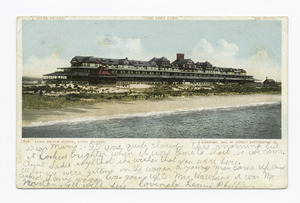
In 1880, Austin Corbin, a builder from Brooklyn, tried to turn the island into a resort. He worked with the Long Island Rail Road (LIRR) to build train tracks to Long Beach. Corbin also opened the Long Beach Hotel, which he said was the world's largest hotel. It had 27 cottages along a 1,100-foot (335 m) stretch of beach. The railroad brought many visitors, but the tracks were removed in 1894 due to storms.
Building the "Riviera of the East"
In 1906, William H. Reynolds, a real estate developer, became involved. He had already developed several neighborhoods in Brooklyn. Reynolds bought the oceanfront land and the rest of the island in 1907. He planned to build a boardwalk, homes, and hotels.
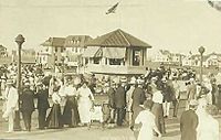
To get attention, Reynolds famously marched a herd of elephants from his amusement park, Dreamland, to help build the Long Beach Boardwalk. This was a great publicity stunt. He also had a wide channel dug on the north side of the island for large boats and seaplanes. This new waterway was named Reynolds Channel. Reynolds wanted Long Beach to be like "The Riviera of the East." He required all buildings to have a special "eclectic Mediterranean style" with white walls and red-tile roofs. He even built a theater called Castles by the Sea.
After Reynolds' company faced financial difficulties in 1918, the building rules were relaxed. The town then attracted many wealthy business people and entertainers.
On July 29, 1907, the Long Beach Hotel caught fire and burned down. One person died, and eight were hurt. A church and other buildings were also destroyed.
Long Beach became an incorporated village in 1913 and a city in 1922.
Changes and Growth in the 20th Century
In the 1920s and 1930s, Long Beach saw some challenges. In 1939, Mayor Louis F. Edwards was sadly killed. After this event, the city decided to change its government system. They adopted a city manager system, which is still in place today. The city manager is hired by the City Council to run the city's daily operations.
In the 1940s, many famous actors like José Ferrer and Mae West performed in local theaters. Other well-known people like John Barrymore and Billy Crystal lived in Long Beach for many years.
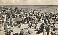
By the 1940s and 1950s, air travel made it easier for people to visit faraway places. Long Beach became more of a "bedroom community" for people who worked in New York City but wanted to live by the beach. It still drew many summer visitors until the 1970s.
In the 1980s and 1990s, Long Beach started to improve with new homes, businesses, and other upgrades. Today, it's a popular place for people who work in New York City but enjoy a quiet beach town. In summer, young people rent bungalows and visit the local shops and restaurants.
Long Beach in the 21st Century
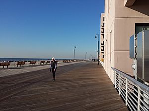
On October 29, 2012, Hurricane Sandy hit Long Beach. The storm caused a lot of flooding and damage to homes and cars. The city lost power and running water for two weeks. The famous boardwalk was also destroyed.
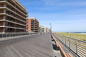
The city worked hard to rebuild the boardwalk with help from FEMA and New York State. The first part of the new boardwalk opened in July 2013, and the whole boardwalk was ready by October 2013. Rebuilding the boardwalk cost $44 million, with most of the money coming from grants.
Geography and Climate
Long Beach covers about 3.90 square miles (10.09 km2). About 2.22 square miles (5.74 km2) is land, and the rest is water.
Long Beach Barrier Island
The city is located on a barrier island off the South Shore of Long Island. It shares this island with other towns like East Atlantic Beach and Lido Beach.
Climate of Long Beach
Long Beach has a warm, humid climate. Summers are hot and humid, and winters are cool. Because of the mild climate, some plants that usually grow in warmer areas can thrive here. Rain falls fairly evenly throughout the year, and there is some snowfall in winter. The city's climate is affected by the nearby Atlantic Ocean.
| Climate data for Long Beach, New York | |||||||||||||
|---|---|---|---|---|---|---|---|---|---|---|---|---|---|
| Month | Jan | Feb | Mar | Apr | May | Jun | Jul | Aug | Sep | Oct | Nov | Dec | Year |
| Record high °F (°C) | 71 (22) |
71 (22) |
85 (29) |
92 (33) |
97 (36) |
100 (38) |
104 (40) |
101 (38) |
98 (37) |
90 (32) |
83 (28) |
75 (24) |
104 (40) |
| Mean daily maximum °F (°C) | 39 (4) |
42 (6) |
49 (9) |
59 (15) |
69 (21) |
78 (26) |
83 (28) |
82 (28) |
75 (24) |
65 (18) |
54 (12) |
44 (7) |
62 (17) |
| Mean daily minimum °F (°C) | 26 (−3) |
28 (−2) |
34 (1) |
44 (7) |
53 (12) |
63 (17) |
69 (21) |
68 (20) |
61 (16) |
50 (10) |
41 (5) |
32 (0) |
47 (9) |
| Record low °F (°C) | −7 (−22) |
−4 (−20) |
7 (−14) |
20 (−7) |
34 (1) |
45 (7) |
48 (9) |
46 (8) |
41 (5) |
30 (−1) |
15 (−9) |
−1 (−18) |
−7 (−22) |
City Layout and Neighborhoods
Long Beach is a very dense city, meaning many people live close together. Less than half of the homes are detached houses. The city is less than 1 mile (1.6 km) wide from the ocean to the bay and about 3.5 miles (5.6 km) long.
The city has different areas:
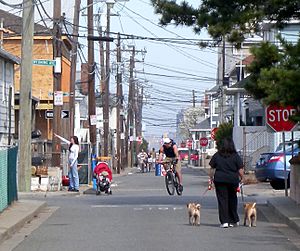
- West End: This area has many small bungalows and some larger houses. The streets are narrow and named after U.S. states. West Beech Street is the main commercial street here.
- East End: This part of the island is wider. It has larger family houses. The city's boardwalk starts here and goes to Neptune Boulevard. Many apartment buildings are along the boardwalk. Park Avenue is the main commercial street.
- Central District: Located between Magnolia Boulevard and Monroe Boulevard. It's known for its diverse population. Long Beach's City Hall is here, along with the Martin Luther King Center.
- The President Streets: This area has nine north-south avenues, with five named after former U.S. presidents.
- The Walks: This area has very narrow sidewalks between houses. Each walk is named after a month.
- North Park: This area is north of Park Avenue, near the LIRR Station. It includes the Long Beach Housing Authority.
- The Canals: This area has several streets running north-south with four canals that connect to Reynolds Channel.
- Westholme: The neighborhood between New York Avenue and Magnolia Boulevard.
Historic Places and Landmarks
Long Beach has several places listed on the National Register of Historic Places. These are important sites that are preserved for their historical value.
- Barkin House
- Cobble Villa
- Granada Towers
- House at 226 West Penn Street
- Pauline Felix House
- Samuel Vaisberg House
- United States Post Office
The city also has important landmarks:
- 9/11 Memorial
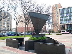
- Holocaust Memorial at Kennedy Plaza
- John F. Kennedy Memorial
- Red Brick District
Museums and Community Centers
- House at 226 West Penn Street (also known as Long Beach Historical & Preservation Society Museum)
- Martin Luther King Community Center
Population and People
| Historical population | |||
|---|---|---|---|
| Census | Pop. | %± | |
| 1920 | 282 | — | |
| 1930 | 5,817 | 1,962.8% | |
| 1940 | 9,036 | 55.3% | |
| 1950 | 15,586 | 72.5% | |
| 1960 | 26,473 | 69.9% | |
| 1970 | 33,127 | 25.1% | |
| 1980 | 34,073 | 2.9% | |
| 1990 | 33,510 | −1.7% | |
| 2000 | 35,462 | 5.8% | |
| 2010 | 33,275 | −6.2% | |
| 2020 | 35,029 | 5.3% | |
| U.S. Decennial Census | |||
In 2020, the population of Long Beach was 35,029 people. The city is one of the most densely populated communities in the United States. This means many people live in a smaller area.
The people of Long Beach come from many different backgrounds. In 2019, about 71.9% of the population was non-Hispanic white. Other groups include African American, Asian, and people of two or more races. About 16.3% of the population was Hispanic or Latin American.
Many people in Long Beach are religious. The largest religious group is Christian, especially Catholic. Other religions practiced in the city include Judaism, Islam, Hinduism, and Buddhism.
Education in Long Beach
Public Schools
The Long Beach City School District serves students in Long Beach. It includes:
- Long Beach Pre-Kindergarten
- West Elementary School
- East Elementary School
- Lido Elementary School
- Lindell Elementary School
- Long Beach Middle School
- Long Beach High School
- Harriet Eisman Community School
Private Schools
- Long Beach Catholic Regional School
- Mesivta of Long Beach
Higher Education
- Rabbinical College of Long Island
Public Libraries
The Long Beach Public Library serves the community. It has a main library downtown and two smaller branches in Point Lookout and the West End.
Getting Around Long Beach
Buses and Trolleys
Long Beach Bus runs a bus service 24 hours a day with five routes. Three routes serve the city, one is an overnight route, and one goes to Lido Beach and Point Lookout. Long Beach Bus also has two seasonal trolley routes in the East and West Loops.
Nassau Inter-County Express (NICE) also has two bus routes that start in Long Beach. These routes connect to places like Roosevelt Field and Far Rockaway.
Train Service
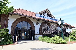
The Long Island Rail Road has a station in Long Beach at Park Place and Park Avenue. This station is a hub where all other public transportation in Long Beach meets. Most trains from here go to Penn Station (Manhattan) in New York City or Atlantic Terminal in Brooklyn.
Famous People from Long Beach
Many well-known people have lived in or are from Long Beach:
- Lil Peep (1996-2017), a rapper and singer.
- MF Doom (1971-2020), a hip-hop artist and producer.
- Larry Brown (born 1940), a basketball star and coach.
- Billy Crystal (born 1948), a famous film and television actor.
- Mike Francesa (born 1954), a New York City radio host.
- Eleanor Holm (1913–2004), an Olympic swimmer and movie star.
- Derek Jeter (born 1974), a former New York Yankees shortstop and team captain.
- Joan Jett (born 1958), a rock singer.
- Rick Rubin (born 1963), a record producer and music executive.
- Charlie McAvoy (born 1997), a defenseman for the Boston Bruins.
|
See also
 In Spanish: Long Beach (Nueva York) para niños
 | Leon Lynch |
 | Milton P. Webster |
 | Ferdinand Smith |


