Reynolds Channel facts for kids
Reynolds Channel is a waterway, also called a strait, located in Nassau County, New York. It acts like a natural divider, separating a group of islands from the main Long Island landmass.
On one side of the channel is Long Beach Barrier Island. This island is home to the City of Long Beach and the villages of Atlantic Beach, Lido Beach, and Point Lookout. On the other side are Barnum Island, Harbor Isle, and other smaller, uninhabited islands.
The channel begins in the west at the East Rockaway Inlet. It then stretches eastward, ending near Point Lookout. Here, it joins with another waterway called the Jones Inlet.
Who Was Reynolds Channel Named After?
Reynolds Channel is named after an important person named William H. Reynolds. He was a developer and also served as a State Senator.
In the early 1900s, William H. Reynolds played a big part in building up the areas around Long Beach Island. Because of his efforts and contributions to the development of the region, this important channel was named in his honor.
Bridges Over the Channel
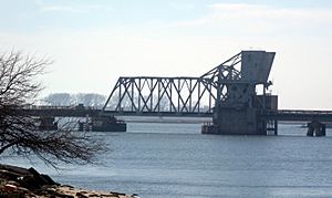
There are four main bridges that cross over Reynolds Channel. These bridges help people and trains travel between the islands and the mainland.
- The Atlantic Beach Bridge carries a road known as NY-878 across the channel.
- The Wreck Lead Bridge is used by trains. It carries the Long Beach Branch of the Long Island Rail Road over the water.
- The Long Beach Bridge carries Long Beach Road, connecting different parts of the area.
- The Loop Parkway Bridge carries the Loop Parkway, another important road, over the channel.
 | Sharif Bey |
 | Hale Woodruff |
 | Richmond Barthé |
 | Purvis Young |


