
Shinnecock Canal facts for kids
Quick facts for kids Shinnecock Canal |
|
|---|---|

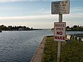
Looking south toward the locks and Shinnecock Bay
|
|
| Specifications | |
| Length | 0.9 miles (1.4 km) |
| Lock length | 250 ft (76 m) |
| History | |
| Date of first use | 1892 |
| Geography | |
| Start point | Peconic Bay |
| End point | Shinnecock Bay |
The Shinnecock Canal is a waterway in Hampton Bays, New York. It is also known as the Shinnecock and Peconic Canal. This canal cuts across the South Fork of Long Island.
The canal is about 4,700 feet (1,400 m) long. It connects Great Peconic Bay in the north with Shinnecock Bay in the south. From Shinnecock Bay, boats can reach the Atlantic Ocean. The Shinnecock Canal first opened for boats in 1892.
Contents
How the Canal Was Built
The Shinnecock Canal was first dug in 1892. It helped boats travel between two large bays. These bays had different water levels. Sometimes, the water level in Peconic Bay was 3 feet (0.91 m) higher than in Shinnecock Bay.
Controlling Water Levels
To fix the water level problem, people built "tide gates" and walls in 1918. These gates were not like the locks we see today. They tried to reduce the difference in water levels. Records show that these changes raised the water level in Shinnecock Bay by one foot.
Size and Features
The canal's width changes from 100 feet (30 m) to 180 feet (55 m). The lock, which helps boats move between different water levels, is 41 feet (12 m) wide. It is also 250 feet (76 m) long.
There are several bridges over the canal. The lowest bridge is for the railroad. It is 22 feet (6.7 m) above the water. The highway bridges are a bit higher, at 23 feet (7.0 m) and 25 feet (7.6 m).
The Only Lock on Long Island
The lock system at Shinnecock Canal is special. It is the only working navigation lock on Long Island. This lock helped to increase the saltiness of the water in Shinnecock Bay. Before the lock, the bay had almost fresh water. This caused many shellfish to die.
Impact of the 1938 Hurricane
The water in Shinnecock Bay became saltier after the Great Hurricane of 1938. This powerful storm broke through a narrow strip of land. It created the Shinnecock Inlet right near the canal. This new inlet made a shorter path for water from the Atlantic Ocean to enter the bay.
Today, about 27,000 boats use this shortcut to the Atlantic Ocean each year.
Canoe Place: A Historical Spot
The area around the canal is called Canoe Place. This name comes from an old Native American word, "Niamuck." It described a place where people carried their canoes between the two bays. This "portage" meant there was no natural water path connecting them. There is no proof that the Montaukett or Shinnecock tribes ever dug a canal here.

Images for kids
-
Looking north toward Peconic Bay from the Shinnecock Canal
