
Miller Place, New York facts for kids
Quick facts for kids
Miller Place, New York
|
|
|---|---|

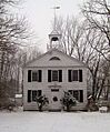
The historic Academy Schoolhouse of Miller Place
|
|

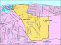
U.S. Census map
|
|

Miller Place, New York
Location in Long Island

Miller Place, New York
Location in New York
|
|
| Country | |
| State | |
| County | Suffolk |
| Town | Brookhaven |
| Area | |
| • Total | 7.73 sq mi (20.01 km2) |
| • Land | 6.55 sq mi (16.96 km2) |
| • Water | 1.18 sq mi (3.05 km2) |
| Elevation | 131 ft (40 m) |
| Population
(2020)
|
|
| • Total | 11,723 |
| • Density | 1,790.04/sq mi (691.12/km2) |
| Time zone | UTC−05:00 (Eastern Time Zone) |
| • Summer (DST) | UTC−04:00 |
| ZIP Code |
11764
|
| Area code(s) | 631, 934 |
| FIPS code | 36-47306 |
| GNIS feature ID | 0957319 |
Miller Place is a small community called a hamlet in Suffolk County, New York. It's also a census-designated place (CDP), which is a special area defined for counting people. Miller Place is part of the Town of Brookhaven.
Even though it has kept much of its old-town feel, Miller Place has grown a lot. It's now a popular place to live, with many homes and families. In 2020, about 11,723 people lived here.
Miller Place and its neighbor, Mount Sinai, have a shared history. They often use the same local places, like the Mount Sinai Congregational Church. The town of Port Jefferson, which is about 5 miles west, is a popular spot for shopping and walking for people from both Miller Place and Mount Sinai.
Contents
History of Miller Place
Early Days as a Farming Town
People have lived in Miller Place since the 1600s. The area is named after the Miller family, who were some of the first people to settle here. For a long time, Miller Place was mostly a farming community.
The land where Miller Place sits was bought from the native Setalcott tribe in 1664. This purchase was made by settlers from Setauket. The land also included what would become Mount Sinai, a nearby community. Miller Place and Mount Sinai have always shared many things throughout their history.
The first known house in the area was built in the 1660s by Captain John Scott. He was an important person in Long Island's early history. This house was called Braebourne. It even appears on a map of New England that Captain Scott helped create.

The Miller family is largely credited with settling the region. In 1679, Andrew Miller, who was a barrel maker from East Hampton, bought a 30-acre plot of land. Records show he came from England or Scotland.

By the early 1700s, the community was known as Miller's Place. The Miller family grew and built many houses in the northern part of the hamlet. Other families like the Helmes, Robinsons, and Woodhulls also joined them. Many roads in Miller Place today are named after these early families.

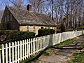
The oldest house still standing is the home of William Miller, Andrew Miller's grandson. It was built in three parts between 1720 and 1816. Many old buildings in Miller Place are found along North Country Road. This area is known as the Miller Place Historic District. It was the first historic district in the Town of Brookhaven in 1976. The Samuel Hopkins House is also listed separately as a historic place.
During the American Revolutionary War, the town was divided. Most people supported the American side, but families sometimes had members on both sides. There were some secret raids at night. In one raid, a teenage Miller was shot after looking out his window.
In 1789, Miller Place and Mount Sinai started a Congregational church together. The church building is in Mount Sinai, but the house for its minister is in Miller Place.
The first public schools in Miller Place opened in 1813 and 1837. In 1834, a private school called the Miller Place Academy was started. It closed in 1868 but later became a public school. Today, the Miller Place Academy building is a symbol of the community and houses a free library.
Becoming a Vacation Spot

In 1895, Miller Place got a train station for the Long Island Rail Road. People could travel west to Port Jefferson and New York City, or east to Wading River. The station burned down in 1903, and a new one was built. But that one also burned down in 1934, and the eastern train lines were soon closed. In 2013, there was a plan to turn the old railroad land into a public bike trail.
In the late 1800s, Miller Place became a popular place for summer vacations. Many beach houses and cabins were built. Businesses opened to serve the visitors. A building called the Harbor House was a vacation home for young girls until it burned down in 1962. Camp Barstow, a Girl Scout camp near the beach, was open until 1980. Now, it's a public park.
Miller Place Today

After World War II, many more people moved to Miller Place. Most of the beach cottages were turned into homes for families.
In 2012, the Town of Brookhaven made a plan for Route 25A, a main road. The plan aims to make the area around Echo and Sylvan Avenues a traditional downtown center. It would have new buildings with shops and homes, and a bigger Sylvan Avenue Park. The plan also wants to protect the DeLea Sod Farm, which is the largest farm left in Miller Place along Route 25A.
Geography and Nature


Miller Place is located on the North Shore of Long Island. It has a two-mile long beach. It is also next to the east side of Mount Sinai Harbor, which it shares with Mount Sinai and Port Jefferson. Miller Place also borders Sound Beach, Rocky Point, Middle Island, and Coram.
The 73rd meridian west passes right through Miller Place. This is a line of longitude on maps.
The area has some hills, especially near the beach. It generally has lots of grass and trees. Even though the soil is good for farming, most farms have been turned into neighborhoods or shopping areas.
People of Miller Place
In 2020, there were 11,723 people living in Miller Place. Most people (about 88.7%) were White. About 9.1% of the population were Hispanic or Latino.
The population includes people of all ages. About 25.7% were under 18 years old. About 16.7% were 65 years or older. Slightly more than half the population (48.6%) were women.
The average income for a household in Miller Place in 2019 was about $130,341. This means that most families earn a good living here. Only a small number of people (2.5%) lived below the poverty threshold.
Economy and Jobs


The main shopping area in Miller Place has moved from the old North Country Road to the newer Route 25A.
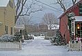
Along North Country Road, you can find McNulty's, a family-owned ice cream shop that's a local favorite. There are also some inns and restaurants in old buildings. Route 25A has more modern businesses, like chain stores in strip malls. You can also find pizza places, a bagel shop, a deli, and a local coffee shop there.
Many people who live in Miller Place travel to New York City for work every day. They might take the Long Island Rail Road from nearby stations in Port Jefferson or Ronkonkoma. Others drive using the large highway system. Some residents also work at Stony Brook University or Brookhaven National Laboratory.
Parks and Fun
Cordwood Landing County Park is a popular place to visit. It has hilly, wooded trails that lead right down to Cedar Beach. It's a great spot for hiking and enjoying nature.
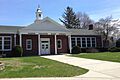
Schools in Miller Place

The Miller Place Union Free School District has four schools. They serve students from Miller Place and much of Sound Beach. These schools are:
- Andrew Muller Primary School (Kindergarten to 2nd grade)
- Laddie A. Decker Sound Beach School (3rd to 5th grade)
- North Country Road Middle School (6th to 8th grade)
- The Miller Place High School (9th to 12th grade)
Miller Place High School is known for its strong academic programs. The school's mascot is a panther, and the school colors are red, white, and blue.
Famous People from Miller Place
- Mike DelGuidice: A guitarist and singer for the Billy Joel Band.
- Ralph Macchio: An actor, famous for movies like The Karate Kid.
- Caleb Smith Woodhull: He was the mayor of New York City from 1849 to 1851.
Images for kids
-
The historic Academy Schoolhouse of Miller Place
-
U.S. Census map
-
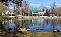
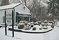
The Miller Place Duck Pond on North Country Road
-
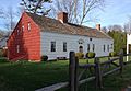
The William Miller House, with sections dating from 1720 to 1816
-
The 1785 Timothy Miller house
-
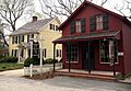
Built in 1890, The Miller Place Country General Store, which formerly served as a combined general store and town post office
-
The Miller Place post office since 1990
-
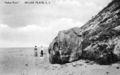
Indian Rock on Miller Place Beach
-

Beach on Long Island Sound in Miller Place
-
Entrance to the Carter Christmas Tree Farm, the only extant farm north of Route 25A
-
McNulty's Ice Cream Parlor
-
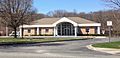
North Country Road Middle School
See also
 In Spanish: Miller Place para niños
