
East Shoreham, New York facts for kids
Quick facts for kids
East Shoreham, New York
|
|
|---|---|

Shoreham Nuclear Power Plant
|
|

U.S. Census map
|
|

East Shoreham, New York
Location in New York
|
|
| Country | United States |
| State | New York |
| County | Suffolk |
| Area | |
| • Total | 6.71 sq mi (17.37 km2) |
| • Land | 5.40 sq mi (13.98 km2) |
| • Water | 1.31 sq mi (3.39 km2) |
| Elevation | 121 ft (37 m) |
| Population
(2020)
|
|
| • Total | 6,841 |
| • Density | 1,267.09/sq mi (489.20/km2) |
| Time zone | UTC−05:00 (Eastern Time Zone) |
| • Summer (DST) | UTC−04:00 |
| ZIP Codes |
11786
|
| Area code(s) | 631, 934 |
| FIPS code | 36-22980 |
| GNIS feature ID | 1867403 |
East Shoreham is a small community in Suffolk County, New York. It is part of the town of Brookhaven in New York, United States. In 2020, about 6,841 people lived there. East Shoreham is also known as a "census-designated place" (CDP), which means it's an area defined by the government for counting people.
Contents
History of East Shoreham
The Shoreham Nuclear Power Plant Story
East Shoreham is known for the Shoreham Nuclear Power Plant. This power plant was approved in 1973. However, it was later closed down because many people protested against it.
The company that built the plant, called Long Island Lighting Company (LILCO), was paid back for some of the money they spent. This payment was made using special bonds. Residents of Long Island are still helping to pay off this debt through their electricity bills.
Geography of East Shoreham
Where is East Shoreham Located?
East Shoreham is located on the North Shore of Long Island. It sits right by the Long Island Sound. The community is about 100 kilometers (70 miles) from New York City.
Land Area and Neighbors
According to the United States Census Bureau, East Shoreham covers about 13.9 square kilometers (5.4 square miles) of land. It does not have any water area within its borders.
East Shoreham shares a post office with the nearby village of Shoreham. They both use the zip code 11786. Even though it's officially called East Shoreham, people who live there often just say "Shoreham." The nearby village is sometimes called "Shoreham Village."
East Shoreham has several neighbors:
- To the east is Wading River, which is in the town of Riverhead.
- To the south is Ridge.
- To the southwest is Rocky Point.
- To the west is the village of Shoreham.
People in East Shoreham
Population and Households
In 2020, there were 6,841 people living in East Shoreham. These people lived in 2,023 households. The community has a mix of different backgrounds. Most residents are White, but there are also African American, Asian, and Native American people. About 10.2% of the population is Hispanic or Latino.
Families and Age Groups
Many households in East Shoreham are families. About 48% of households have children under 18 living there. Most families are married couples living together.
The average household has about 3.2 people. The average family has about 3.4 people.
The population includes people of all ages:
- About 29.9% are under 18 years old.
- About 7.5% are 65 years or older.
The average age of people in East Shoreham is 37 years.
Education in East Shoreham
East Shoreham is part of the Shoreham-Wading River School District. This district also includes the village of Shoreham and the nearby community of Wading River.
Images for kids
-
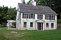
The Josiah Woodhull house, built in 1720, is the oldest house in the Shoreham area.

See also
 In Spanish: East Shoreham para niños
