Lonelyville, New York facts for kids
Quick facts for kids
Lonelyville
|
|
|---|---|
| Country | United States |
| State | New York |
| County | Suffolk |
| Township | Islip |
| Time zone | UTC-5 (EST) |
| • Summer (DST) | UTC-4 (EDT) |
| ZIP code |
11706
|
| Area code(s) | 631 |
Lonelyville is a small, quiet beach community. It's located on the western side of Fire Island. This area is part of the Town of Islip in Suffolk County, New York, United States.
Lonelyville has about 80 houses. It sits between the communities of Dunewood and Atlantique. Like many places on Fire Island, cars are usually not allowed here in the summer. People mostly get around using bicycles.
The closest boat (ferry) service is to Dunewood. You can catch this ferry from Bay Shore on Long Island. Lonelyville itself doesn't have any stores, cafes, or restaurants. But it's an easy walk or bike ride to Fair Harbor. Fair Harbor has shops and places to eat, acting like a small town center for the area. Most houses in Lonelyville are used for summer vacations. Only a few people live here all year round.
One of the most famous people who lived in Lonelyville was Mel Brooks. He was a famous comedian and filmmaker. His wife, Anne Bancroft, was also a well-known actress. They owned a house by the ocean for many years. People say Mel Brooks wrote many of his movies and comedy shows there. Their house was also the first project designed by a famous architect named Richard Meier in 1963.
History of Lonelyville
It's not clear when the first house was built in Lonelyville. Some people think fishermen might have used the area as a camping spot in the late 1890s.
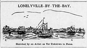
By 1908, three friends from Bay Shore, New York, had built houses here. They were businessmen who enjoyed fishing and hunting ducks. Harry M. Brewster built "Brewster’s Bungalow." Harry S. Raven built "Raven’s Ranch." Selah T. Clock built "Clock’s Castle."
One evening, at dinner, Brewster suggested calling the place "Lonelyville." They celebrated the new name with champagne.
The three friends also made up some funny rules for Lonelyville. They were the only ones who could vote on these rules.
- "No person or persons not of good moral character shall be permitted to dwell with the city limits." (But the people already living there were allowed to stay!)
- "No saloons, dives or gambling resorts shall be permitted within a mile of any church or school house."
- "The Sabbath day shall be strictly observed by every person in sound health taking a bath."
- "There shall be no horse racing, cock fights of firemen’s tournaments on Sundays."
- "The board of Aldermen shall be responsible that shall see that the tide rises and falls every day and that the surf continues to roll in."
In 1909, Captain Ed Thompson built another house. It was "a good many miles from the noise of everything but the surf."
The Fishing Pier Project
In June 1915, Captain Clock and Captain Thompson planned a big project. They wanted to build a 1,000-foot-long pier into the ocean. They also wanted to start the Fire Island Fishing Company.
The idea was to make it easier for fishing boats to unload their catch. They would also use large fishing nets that stretched far out from the pier. The fish would then be loaded onto a small railroad system. This railroad would carry the fish across the island to another pier on the bay side. From there, the fish would go onto other boats and sail to the mainland. This plan saved fishermen a lot of time. It helped them avoid the difficult trip through Fire Island Inlet.
The long pier became a well-known landmark. It stayed standing for a long time, even after the fishing company closed. However, a huge storm called the 1938 New England hurricane finally destroyed what was left of the pier in 1938.
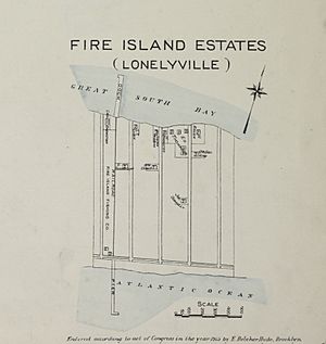
A map from 1915 also shows Lonelyville listed as "Fire Island Estates." This map shows the pier and the railroad tracks for the fishing company. The 1938 hurricane completely ruined the ocean pier. Only the bay side part of the dock remained until the 1950s.
Even in August 2008, you could still see parts of the pier's foundation. These parts were about 100 feet offshore and under 20 feet of water.
 | Calvin Brent |
 | Walter T. Bailey |
 | Martha Cassell Thompson |
 | Alberta Jeannette Cassell |


