Central Islip, New York facts for kids
Quick facts for kids
Central Islip, New York
|
|
|---|---|

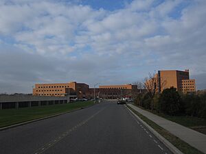
The Suffolk County court buildings in Central Islip in 2009.
|
|

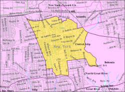
U.S. Census map
|
|
| Country | |
| State | |
| County | Suffolk |
| Town | Islip |
| Area | |
| • Total | 7.16 sq mi (18.53 km2) |
| • Land | 7.16 sq mi (18.53 km2) |
| • Water | 0.00 sq mi (0.00 km2) |
| Elevation | 85 ft (26 m) |
| Population
(2020)
|
|
| • Total | 36,714 |
| • Density | 5,131.24/sq mi (1,981.27/km2) |
| Time zone | UTC-5 (Eastern (EST)) |
| • Summer (DST) | UTC-4 (EDT) |
| ZIP codes |
11722, 11749, 11760
|
| Area code(s) | 631, 934 |
| FIPS code | 36-13552 |
| GNIS feature ID | 0946246 |
Central Islip (also known as CI) is a community in Suffolk County, New York. It is a type of town called a hamlet. It is also a census-designated place, which means it's an area defined for gathering population data. Central Islip is part of the larger Town of Islip. In 2020, about 36,714 people lived here.
Contents
History of Central Islip
Early Days and Native Americans
Before European settlers arrived, the Secatogue tribe lived in this area. They were part of the Algonquin native-American group. They lived off the land and water for many years.
Railroad and Growth
In 1842, the Long Island Rail Road expanded its tracks. A station called Suffolk County Station opened in the area. This station became a busy spot for homes and businesses. Because of this, the name Central Islip was created. A new station was built in 1873. The modern Central Islip station is now in a different spot.
The Psychiatric Center
In 1889, a large hospital called the Central Islip Psychiatric Center opened. It was a very big hospital. It cared for many patients for a long time. This hospital closed its doors in 1996.
Modern Central Islip
In the mid-1990s, Central Islip started to grow again. Many new homes and businesses were built. New government buildings also appeared. A large federal courthouse complex opened. It is one of the biggest in the country. It was built on part of the old psychiatric center's land. In 2000, a baseball stadium opened for the Long Island Ducks team.
New Housing Areas
Central Islip has many different housing areas. Some of these include:
- College Woods
- Park Row
- Bella Casa Estates
- Islip Landing
- Courthouse Commons
- Waddington Estates
- Hawthorne Court (Home Properties)
- Coventry Village
Geography of Central Islip
Central Islip covers about 18.4 square kilometers (7.1 square miles). All of this area is land. There are no large bodies of water within the community itself.
People of Central Islip
| Historical population | |||
|---|---|---|---|
| Census | Pop. | %± | |
| 2000 | 31,950 | — | |
| 2010 | 34,450 | 7.8% | |
| 2020 | 36,714 | 6.6% | |
| U.S. Decennial Census | |||
Central Islip is home to many different people. In 2010, there were 34,450 people living here. The community is very diverse. Many people from different backgrounds live in Central Islip. About 52.1% of the people were of Hispanic origin. Many residents were also born in other countries.
The community has a mix of age groups. About 29.2% of the people were under 18 years old. The average age was 32 years. This shows it is a community with many families and young people.
Schools in Central Islip
The Central Islip Union Free School District runs the public schools.
Public Schools
- Pre-K and Kindergarten:
- Early Childhood Center (Alfano)
- Grades 1-6:
- Andrew T. Morrow Elementary
- Francis J. O'Neil Elementary
- Marguerite Mulvey Elementary
- Cordello Ave. Elementary
- Mulligan Elementary
- Anthony Alfano Elementary
- Grades 7-8:
- Ralph G. Reed Middle School
- Grades 9-12:
- Central Islip Senior High School
Private Schools
- St. John of God (Catholic)
- Our Lady of Providence Regional School
Central Islip was also home to some colleges. These included NYIT (the New York Institute of Technology) and Touro Law Center. They were located near the local New York Supreme Court building.
Churches in Central Islip
Central Islip has many different places of worship. Some of these include:
- Central Islip Seventh-Day Adventist Church, 143 Caleb's Path
- Central Islip Church of Christ
- First Spanish Baptist Church, 51 Hawthorne Avenue
- The First United Methodist Church (dating back to 1869) on Wheeler Rd.
- Iglesia Fuente de Agua Viva, 100 East Suffolk Ave Central Islip NY 11722
- Iglesia Bíblica TorreFuerte
- Iglesia Evangelica Resurreccion
- Ministerio Jesu Cristo Vive, 1417 Islip Avenue
- Lighthouse Tabernacle Church of God
- St. John of God Roman Catholic Church (one of the oldest churches in Central Islip)
- The Episcopal Church of The Messiah
- Kingdom Hall of Jehovah's Witnesses, 268 Suffolk Avenue
- Kingdom Hall of Jehovah's Witnesses, 105 Fig Street
- Restoring Grace Ministries
Transportation in Central Islip
Central Islip has several ways to get around.
Roads
Major roads in the area include:
- Suffolk County Road 17: Also known as Carleton Avenue and Wheeler's Road.
- Suffolk County Road 67: This road is also known as the Long Island Motor Parkway. It runs along the northern edge of the community.
- Suffolk County Road 100: Known as Suffolk Avenue, this is a main road that goes from west to east through Central Islip.
- Southern State Parkway: This parkway is very close to Central Islip.
Airport
Long Island MacArthur Airport is located nearby in Ronkonkoma.
Train
The Central Islip Station is on the Ronkonkoma Branch of the Long Island Rail Road. This train line connects Central Islip to other parts of Long Island and New York City.
Buses
Several bus routes serve Central Islip. These include routes 4, 6, 17, 52A, and 52B. They are part of the Suffolk County Transit system.
Sports in Central Islip
| Club | Sport | League | Venue | Logo |
| Long Island Ducks | Baseball | Atlantic League of Professional Baseball | Fairfield Properties Ballpark | Link to file |
Famous People from Central Islip
Some well-known people have lived in Central Islip, including:
- Rick Kittles
- Mike Tice
- R.A. the Rugged Man
- Anthony Cumia
- Chrisette Michele
- Keith Murray (rapper)
- K-Solo
- Roy Barker
See also
 In Spanish: Central Islip para niños
 | Percy Lavon Julian |
 | Katherine Johnson |
 | George Washington Carver |
 | Annie Easley |


