Brightwaters, New York facts for kids
Quick facts for kids
Brightwaters, New York
|
|
|---|---|
| Incorporated Village of Brightwaters | |

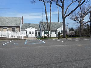
The Brightwaters Village Hall in April 2019.
|
|

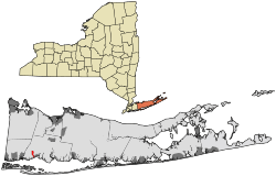
Location within Suffolk County.
|
|
| Country | |
| State | |
| County | Suffolk |
| Town | Islip |
| Incorporated | November 30, 1916 |
| Area | |
| • Total | 0.99 sq mi (2.56 km2) |
| • Land | 0.97 sq mi (2.50 km2) |
| • Water | 0.02 sq mi (0.06 km2) |
| Elevation | 23 ft (7 m) |
| Population
(2020)
|
|
| • Total | 3,181 |
| • Density | 3,292.96/sq mi (1,271.92/km2) |
| Time zone | UTC-5 (Eastern (EST)) |
| • Summer (DST) | UTC-4 (EDT) |
| ZIP code |
11718
|
| Area code(s) | 631 |
| FIPS code | 36-08323 |
| GNIS feature ID | 0975774 |
| Website | |
Brightwaters is a lovely village located in the southwestern part of the Town of Islip. It's in Suffolk County, which is on Long Island in New York, United States. According to the 2020 census, about 3,181 people live in Brightwaters.
Contents
History of Brightwaters Village
Brightwaters was first developed in the early 1900s. A company called the T. B. Ackerson Company helped build the community. This company was also known for its work in Brooklyn.
Becoming an Incorporated Village
By 1916, the people living in Brightwaters felt it would be better if their community became an official village. At that time, it was just an unincorporated part of the Town of Islip. Residents were concerned about their taxes and how they had to pay for private services. They believed these services should be provided by the town through their taxes.
So, the locals signed a petition to make Brightwaters an official village. This petition was given to the Town of Islip on September 20, 1916. Just a few months later, on November 30, 1916, Brightwaters officially became an incorporated village.
Geography of Brightwaters
Brightwaters covers a total area of about 2.6 square kilometers (which is about 1 square mile). Most of this area, about 2.5 square kilometers, is land. A small part, about 0.1 square kilometers, is water.
Natural Features and Districts
The village has some cool natural spots. You can find Wohseepee Park in the northern part of Brightwaters. There's also the Brightwaters Canal, which is south of Montauk Highway. North of Montauk Highway, there are four beautiful lakes: Cascades Lake, Mirror Lake, Lagoon Lake, and Nosrekca Lake.
The main businesses in the village are located where Windsor Avenue and Orinoco Drive meet. This area is often called Brightwaters Village. The village is divided into three main areas based on its geography:
- Canal District: This is the southern part of Brightwaters, everything south of Montauk Highway.
- Lakes District: This is the central part, stretching from north of Montauk Highway to Union Boulevard.
- Wohseepee Park District: This is the northern part, from north of Union Boulevard to Seneca Drive.
Brightwaters uses its own special ZIP code, 11718. This is different from the nearby Bay Shore area.
Population and People
| Historical population | |||
|---|---|---|---|
| Census | Pop. | %± | |
| 1920 | 250 | — | |
| 1930 | 1,061 | 324.4% | |
| 1940 | 1,562 | 47.2% | |
| 1950 | 2,336 | 49.6% | |
| 1960 | 3,193 | 36.7% | |
| 1970 | 3,808 | 19.3% | |
| 1980 | 3,286 | −13.7% | |
| 1990 | 3,265 | −0.6% | |
| 2000 | 3,248 | −0.5% | |
| 2010 | 3,103 | −4.5% | |
| 2020 | 3,181 | 2.5% | |
| U.S. Decennial Census | |||
The population of Brightwaters has changed over the years. In 2010, there were 3,103 people living in the village. By 2020, the population grew slightly to 3,181 residents.
Diversity in Brightwaters
Brightwaters is home to people from many different backgrounds. In 2010, most residents were White. There were also people who identified as African American, Asian, Native American, and from other races. Some residents identified with two or more races. A portion of the population was also of Hispanic or Latino heritage.
Parks and Recreation
Brightwaters offers several parks where residents can enjoy outdoor activities. These parks provide green spaces for relaxation and play.
Parks in Brightwaters
- Gilbert Park
- Walker Beach
- Wohseepee Park
Education in Brightwaters
Children living in Brightwaters attend public schools within the Bay Shore Union Free School District. This means that all students in Brightwaters go to schools in Bay Shore. The village is also part of the Bay Shore–Brightwaters Public Library District, providing library services to the community.
Notable Person from Brightwaters
- Rick Lazio – A former Congressman who once lived in Brightwaters.
See also
 In Spanish: Brightwaters (Nueva York) para niños
 | Janet Taylor Pickett |
 | Synthia Saint James |
 | Howardena Pindell |
 | Faith Ringgold |


