
Freeport, New York facts for kids
Quick facts for kids
Freeport, New York
|
||
|---|---|---|
| Incorporated Village of Freeport | ||

Freeport Village Hall, also known as the Municipal Building, was built in 1928 to replicate Independence Hall in Philadelphia, and was enlarged in 1973.
|
||
|
||

Location in Nassau County and the state of New York.
|
||

Freeport, New York
Location in Long Island

Freeport, New York
Location in New York

Freeport, New York
Location in the United States
|
||
| Country | ||
| State | ||
| County | Nassau | |
| Town | Hempstead | |
| Incorporated | 1892 | |
| Area | ||
| • Total | 4.87 sq mi (12.61 km2) | |
| • Land | 4.58 sq mi (11.86 km2) | |
| • Water | 0.29 sq mi (0.76 km2) | |
| Elevation | 20 ft (6 m) | |
| Population
(2020)
|
||
| • Total | 44,472 | |
| • Density | 9,714.29/sq mi (3,750.58/km2) | |
| Time zone | UTC−5 (Eastern (EST)) | |
| • Summer (DST) | UTC−4 (EDT) | |
| ZIP Code |
11520
|
|
| Area code(s) | 516 | |
| FIPS code | 36-27485 | |
| GNIS feature ID | 2390852 | |

Freeport is a village located in Nassau County, on the South Shore of Long Island. It is part of the town of Hempstead in New York state, United States. In 2010, its population was 43,713, making it the second-largest village in New York by population.
Freeport has been a settled community since the 1640s. It was once known for its oyster fishing. Later, it became a popular vacation spot, especially for people involved in the New York City theater scene. Today, many people who live in Freeport commute to work in nearby cities. However, it still has a busy waterfront area and some light industries.
Contents
Freeport's History
Early Beginnings
Before European settlers arrived, the land where Freeport now stands belonged to the Meroke Indians. Records show that people have lived in this area since the 1640s. In colonial times, it was known as "the Great South Woods."
Around the mid-1600s, a herdsman named Edward Raynor moved here from Hempstead. He cleared land and built a cabin. Because of him, the area was first called Raynor South, and then Raynortown.
Growing into a Village
In 1853, the people living here decided to change the village's name to Freeport. This name came from a nickname used by ship captains. They called it "Freeport" because they didn't have to pay taxes to unload their goods there.
After the Civil War, Freeport became a major center for catching and selling oysters. However, this business started to slow down in the early 1900s. This was due to changes in the water and more pollution in Great South Bay. Even today, Freeport and nearby Point Lookout still have a lot of commercial fishing activity close to New York City.
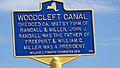
In 1868, the Southside Railroad came to Freeport. This really helped the village grow. A key person in this growth was a developer named John J. Randall. He created several canals, including the Woodcleft Canal. One side of this canal is now famous as the "Nautical Mile." Randall also built a unique Victorian house very quickly to challenge other builders who wanted everything in a straight grid. This house, known as the Freeport Spite House, is still standing and lived in today.
In 1892, the village officially became incorporated. At that time, about 1,821 people lived there. Freeport also started its own electric company in 1898. This company still operates today, giving residents lower electricity costs than nearby towns. Public street lights were added in 1907, and a fire alarm system began in 1910.
The Early 1900s: A Time of Expansion

In the early 1900s, Freeport was a popular place for tourists and people who enjoyed boating and fishing.
From 1902 to the late 1920s, trolleys ran through Freeport. They connected the village to places like Jamaica, Hempstead, and Brooklyn. These trolleys went down Main Street and connected to ferries. The ferries took people to Point Lookout, which has an ocean beach. For a few years after 1913, a trolley nicknamed "the Fishermen's Delight" also ran along Grove Street (now Guy Lombardo Avenue).
In 1910, Arthur and Albert Heinrich built and flew the first American-made monoplane from their airplane factory on Merrick Road. WGBB, founded in 1924, became Long Island's first radio station to broadcast 24 hours a day.
Freeport became a summer home for many famous actors, especially vaudeville performers. This started around the early 1900s with people like Diamond Jim Brady and Lillian Russell. Many performers had year-round homes in Freeport. Some famous names included Leo Carrillo, Victor Moore, Fannie Brice, Sophie Tucker, Will Rogers, and Buster Keaton.
Several actors formed a group called the Long Island Good Hearted Thespian Society (LIGHTS). They put on summer shows in Freeport. LIGHTS also held a summer "Christmas Parade" with clowns and acrobats. This was because the theater people were busy working during the actual Christmas season. A fun Coney Island–style amusement park called Playland Park was open from the early 1920s until it was destroyed by a fire in 1931.
Modern Freeport

By 1937, Freeport's population was over 20,000, making it the largest village in Nassau County. After World War II, Freeport became a "bedroom community" for New York City. This means many people lived in Freeport but worked in the city.
Freeport has also been home to important boat-building companies. Fred and Mirto Scopinich built boats for the United States Coast Guard and even for rumrunners during Prohibition. From 1937 to 1945, their shipyard built small boats for the United States Navy and British Royal Navy. The marina started by Al Grover in 1950 is still in Freeport today. In 1985, Grover and his sons made history. They crossed the Atlantic Ocean from Nova Scotia to Portugal in one of his 26-foot fishing skiffs. This was the first time a boat powered by an outboard motor had done this.
Another company, Columbian Bronze, operated in Freeport from 1901 to 1988. They made the propeller for the USS Nautilus. This was the first nuclear-powered submarine and the first vessel to travel completely underwater across the North Pole.
Freeport's Location
Freeport covers an area of about 4.6 square miles (12.61 square kilometers).
The village is divided by New York State Route 27 (Sunrise Highway), which runs east to west. The Meadowbrook State Parkway forms the eastern edge of Freeport.
The southern part of the village has several canals. These canals allow boats to reach the Atlantic Ocean through salt marshes. The oldest canal is the Woodcleft Canal, built in the late 1800s. Freeport has many places for small boats and a local fishing fleet. You can also find charter boats and open water fishing boats here.
People of Freeport
Freeport is home to a diverse population. In 2020, the total population was 44,472. The village has a mix of different cultures and backgrounds. Many residents are from Hispanic or Latino backgrounds, including people from the Dominican Republic, El Salvador, Puerto Rico, Guatemala, Colombia, and Ecuador.
In 2000, there were about 13,504 households in Freeport. About 36.4% of these households had children under 18 living with them. The average household size was 3.20 people.
Getting Around Freeport
Roads
Two main roads, Merrick Road and Sunrise Highway, run through Freeport from east to west. The Meadowbrook State Parkway forms part of Freeport's eastern border. The Southern State Parkway is about a mile north of Freeport's northern border.
Trains
Freeport has its own train station, the Freeport station. It is on the Long Island Rail Road's Babylon Branch. This makes it easy to travel to other parts of Long Island and to Manhattan.
Buses
Freeport is a central point for several Nassau Inter-County Express bus routes. These buses connect Freeport to places like Jamaica, Sunrise Mall, Mineola, Roosevelt Field Mall, and Jones Beach (during summer).
Utilities
Freeport has its own water system, which provides water to the entire village. The village also has a sanitary sewer system. This system sends wastewater to Nassau County's treatment plants for cleaning.
Fun and Culture in Freeport

Freeport is a popular spot on Long Island during the summer. Every year, a big festival takes place on Freeport's Nautical Mile. This is on the west side of the Woodcleft Canal. Many people from Long Island and New York City come to enjoy it.
The Nautical Mile is a lively area along the water. It has famous seafood restaurants, crab shacks, bars, unique shops, and fresh fish markets. You can also find party cruise ships and casino boats that float on the canals. People enjoy boat rides and eating fresh seafood like mussels, oysters, and clams at restaurants with waterside seating. There's also an 18-hole miniature golf course that families love. The Sea Breeze waterfront park opened in 2009. It has a marina, a boardwalk, and benches, making it a great place to watch boats and enjoy the scenery.
Freeport is also a gateway to Jones Beach, one of New York's largest state beaches. The Town of Hempstead Marina is a popular place where many people dock their boats.
From 1974 to 1986, Freeport had a large outdoor market area called the Freeport Mall. The main street was closed to cars for pedestrians. However, this idea didn't work out well, and many businesses struggled. Eventually, the mall was removed, and the street was reopened to traffic.
Buildings and Landmarks

North of the high school and railroad tracks are the remains of the former Brooklyn Waterworks. This building, designed by architect Frank Freeman, opened in 1891. It supplied water to the city of Brooklyn. It was used until 1929 and remained on standby until 1977.
Freeport also has historic waterfront buildings. These include Fiore's Fish Market and Two Cousins, where owners could buy fish directly from the baymen as they came into the dock.
Libraries
The Freeport Memorial Library is the main library serving the Freeport Library District. Some northern parts of the village are served by the Baldwin and Roosevelt Library Districts.
Schools in Freeport

Freeport Public Schools (FPS) runs the public schools in the community. In the 2009–10 school year, over 6,200 students were enrolled.
Children in grades 1–4 attend four special elementary schools, each with a different focus:
- Archer Street (Microsociety and Multimedia)
- Leo F. Giblyn (School of International Cultures)
- Bayview Avenue (School of Arts and Sciences)
- New Visions (School of Exploration & Discovery)
All public school children in grades 5 and 6 attend Caroline G. Atkinson School. Seventh and 8th graders go to John W. Dodd Middle School. There is also a Catholic school, the De La Salle School, for boys in grades 5–8.
Students in grades 9–12 attend Freeport High School. Its mascot is the Red Devil, and its colors are red and white. The school has great sports facilities, including a track and field. Freeport High School offers many advanced courses. About 87% of its graduates go on to higher education.
As early as 1886, Freeport's schools started giving students free textbooks, which was unusual at the time. In 1893, the village built a new ten-room brick schoolhouse. Freeport was also one of the first Long Island communities to offer classes beyond elementary school.
The Freeport High School newspaper, Flashings, started in 1920. It is thought to be the oldest high school paper on Long Island and has won many awards.
In 2010, Freeport was recognized for its eighth-grade students' high scores on Regents Exams. These exams are usually given to older students. Around 1970, Freeport High School was one of the few schools in the country to have a computer for students to use and learn programming.
Sports and Fun

In the early 1930s, Freeport was home to the Pennsylvania Red Caps of New York, a semi-pro baseball team. For a few years, the NFL's Brooklyn Dodgers football team used a stadium in Freeport for training. This site is now a BJ's Wholesale Club warehouse.
From 1931 to the early 1980s, Freeport had the Freeport Speedway. This stadium could seat about 10,000 people. It first hosted "midget" auto races. After World War II, it switched to stock car racing and later demolition derbies.
Freeport also has the Freeport Recreation Center. This center has an indoor ice skating rink that's open all year. It also has indoor and outdoor swimming pools, handball courts, saunas, gyms, and basketball courts. The "Rec Center" offers classes for adults, camp programs, and a senior center.
Famous People from Freeport
Many notable people have lived in or have connections to Freeport:
- Cindy Adams, a well-known gossip columnist.
- Leo Carrillo, an actor famous for playing Pancho in the Cisco Kid series.
- Broderick Crawford, an actor.
- D'Brickashaw Ferguson, a Pro Bowl offensive tackle for the New York Jets.
- Flavor Flav (William Jonathan Drayton, Jr.), a rapper and reality TV star.
- Guy Lombardo, a famous musician and big bandleader, lived in Freeport.
- Eddie Murphy, the famous comedian and actor, attended middle school here.
- Lou Reed, a singer-songwriter and a founding member of The Velvet Underground.
- Dick Schaap, a sportswriter, broadcaster, and author.
- Dee Snider, the singer from the band Twisted Sister.
- Brandon Tartikoff, a television executive.
- Harold E. Varmus, who won the Nobel Prize in Physiology or Medicine in 1989.
Images for kids
-
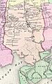
Map of Freeport, 1873
-
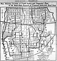
Map of Freeport, 1921
-
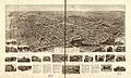
1909 Hughes & Bailey map
-
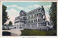
A 1910s postcard of the Crystal Lake Hotel.
-
Woodcleft Canal Historic Marker
-
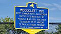
Woodcleft Inn historic marker
-
Archer Street School Historic marker
-
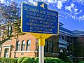
Seaman Ave school #2 historic marker Freeport NY
-
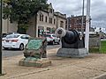
Trubia Rifles & Dedication Plaque


See also
 In Spanish: Freeport (Nueva York) para niños
