
Brace Mountain facts for kids
Quick facts for kids Brace Mountain |
|
|---|---|

Mountain from southwest
|
|
| Highest point | |
| Elevation | 2,311 ft (704 m) |
| Prominence | 100 ft (30 m) |
| Parent peak | Mount Frissell |
| Listing | |
| Geography | |

Brace Mountain
Location in New York
|
|
| Location | North East, New York and Salisbury, Connecticut |
| Parent range | Taconic Mountains |
| Topo map | USGS Ashley Falls, Copake |
| Geology | |
| Age of rock | Ordovician |
| Mountain type | Thrust fault; metamorphic rock |
| Climbing | |
| Easiest route | South Taconic Trail |
Brace Mountain is a cool mountain peak in the southern Taconic Mountains. It's special because it's close to where three U.S. states meet: New York, Connecticut, and Massachusetts.
The main top of Brace Mountain is 2,311 feet (704 meters) high and is located in New York. It's actually the highest point in Dutchess County!
Parts of the mountain in New York and Massachusetts are protected areas. This means they are like nature parks. The parts in Connecticut are owned by private people but are also looked after to keep them natural.
Brace Mountain is a popular spot for hikers. Its top, along with a smaller peak called South Brace Mountain, is part of the 15.7-mile (25.3 km) long South Taconic Trail. The very top of Brace Mountain is open and grassy, offering amazing views in every direction. It's also a favorite place for people who enjoy hang gliding and paragliding.
Contents
Where is Brace Mountain Located?
Brace Mountain is found near the southern end of a steep slope. This slope runs north-south, close to the state lines of Connecticut and Massachusetts. It's in a town called North East, New York.
To the east of the mountain is a large, undeveloped area called the Riga Plateau. Here you'll find Riga Lake, which is the highest lake in Connecticut. Just a bit further east is Bear Mountain, the highest point in Connecticut.
Nearby Peaks and State Borders
About 1 mile (1.6 km) northeast of Brace Mountain is Mount Frissell. This mountain is just over the border in Massachusetts. A short distance from Mount Frissell's top, you'll find the highest spot in Connecticut, at 2,370 feet (722 meters).
About 0.3 miles (0.5 km) north-northeast of Brace Mountain's top is a special spot. This is the tripoint where New York, Connecticut, and Massachusetts all meet!
The mountain ridge continues north to Alander Mountain. This is where the highest point in Columbia County is located, right on the state line.
The Valleys and Rivers Around Brace Mountain
The west side of Brace Mountain drops steeply down about 1,300 feet (400 meters) to a narrow valley. This area is called the Harlem Valley. It was once claimed by both New York and Connecticut a long time ago!
The water from the west side of Brace Mountain flows into the Noster Kill, then Bash Bish Brook, and finally into the Hudson River. Water from the southwest side goes into Webatuck Creek and then the Housatonic River. The southeast side drains into Riga Lake and then also into the Housatonic River. Water from the north side flows into Ashley Hill Brook and then the Roeliff Jansen Kill.
How Can You Hike Brace Mountain?
The South Taconic Trail is marked with white blazes (paint marks on trees) and goes right over the top of Brace Mountain. This trail is the main way to reach the summit. You can start your hike from the west side or connect from the Mount Frissell trail on the east.
Hiking from the West (New York Side)
Hiking from the west is a common way to reach the top, but it's also the steepest climb. The trail starts on Quarry Hill Road in New York, at an elevation of almost 1,000 feet (300 meters).
The path goes through an old field and then into the woods. It enters Taconic State Park and climbs steeply. You might even need to use your hands to scramble up some parts!
The trail levels out at about 1,700 feet (520 meters). Here, you'll start to see amazing views of the Catskills across the Hudson River. The total hike from this starting point is about 1.9 miles (3.1 km), with a climb of 1,300 feet (400 meters).

Hiking from the East (Connecticut/Massachusetts Side)
The Mount Frissell Trail starts on the state line, on a road called East Street. From an elevation of 1,830 feet (558 meters), it goes into Massachusetts, then back into Connecticut. It climbs to the open top of Round Mountain, where you can see Brace Mountain ahead.
After going down into the woods, it re-enters Massachusetts and climbs steeply to the top of Mount Frissell. Near the top, you'll find a small marker for the highest point in Connecticut. From there, the trail gently drops down to the tri-state marker (where the three states meet).
This trail then connects to the South Taconic Trail about 0.3 miles (0.5 km) north of Brace Mountain's top. This route is about 2.5 miles (4 km) long and includes climbing Round and Frissell mountains.
Other Ways to Reach the Top
There's also an unofficial dirt road that offers an easier and shorter way to the top. It starts from a small parking area on Mount Washington Road in Connecticut. This path is about 1.7 miles (2.7 km) long. However, it's not used as much because parking is limited and the trail isn't well-maintained.
There are also longer trails from the north, like the Robert Brook Trail in New York and the Ashley Hill Trail in Massachusetts. These trails offer different ways to explore the area and eventually reach Brace Mountain.
What's at the Top of Brace Mountain?
The very top of Brace Mountain is an open, grassy area. There's a large pile of stones called a cairn several feet high, with a small windsock on it. From here, you can see in all directions!
To the west, you can see the highest mountains visible from Brace, which are the Catskills. You can spot the long Catskill Escarpment to the north, with Hunter Mountain (4,040 feet / 1,231 meters) standing tall. Further south, you might see Slide Mountain, the highest peak in the Catskills at 4,180 feet (1,274 meters).
To the east, the land drops down into the Riga Plateau. You can see Gridley and Bear mountains across it, and Riga Lake to the south. On clear days, you might even see Mount Greylock, Massachusetts' highest peak, far in the distance.

Brace Mountain for Hang Gliding and Paragliding
Brace Mountain is a popular spot for hang gliding and paragliding. The Mount Brace Outdoor Club helps manage these activities.
If you want to fly from the mountain, you need to sign in at the club first. This is important for safety and is done with permission from the state park office. Pilots who don't check in can get a fine.
There are also rules for pilots:
- They must be members of the United States Hang Gliding and Paragliding Association (USHPA).
- They need a certain skill level (P3/H2 or higher) to fly without an instructor.
- No flights are allowed if winds are stronger than 26 miles per hour (42 km/h).
The windsock on the summit cairn helps pilots check the wind conditions. Pilots usually hike up from the east or from the South Taconic Trail. Brace Mountain is a favorite place for these sports in the Northeast because of its gentle slopes and good air currents (thermals) that help pilots fly smoothly.
Images for kids
-
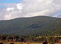
Mountain from southwest
-
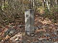
Tristate marker
-
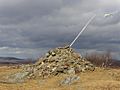
Summit cairn
