Hunter Mountain (New York) facts for kids
Quick facts for kids Hunter Mountain |
|
|---|---|
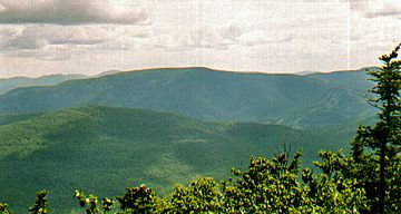
Hunter Mountain from Black Dome to the north. Ski trails visible at right.
|
|
| Highest point | |
| Elevation | 4,040 feet (1,231 m)+ |
| Prominence | 2,160 ft (660 m) |
| Listing |
|
| Geography | |
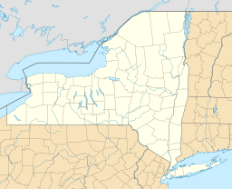
| Location | New York, US |
| Parent range | Catskills |
| Topo map | USGS Hunter |
| Climbing | |
| First ascent | unknown |
| Easiest route | old road |
Hunter Mountain is a tall peak in the Catskill Mountains of New York State, United States. It stands about 4,040 feet (1,231 meters) high. This makes it the highest point in Greene County and the second-highest peak in the entire Catskill range.
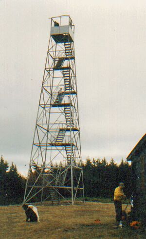
Even though there's a popular ski area called Hunter Mountain on one side, the actual mountain is much bigger. Its true summit, which is a bit away from the ski slopes, has a fire lookout tower. This tower is the highest in New York State and the second-highest in the entire Northeast region. An old road leading to the summit is now a favorite path for hikers and people riding horses.
Contents
Exploring Hunter Mountain's Geography
Hunter Mountain looks like a long, gentle ridge. It rises steeply from an area called Stony Clove Notch on its east side. Then, it slopes gently up to the summit in the middle, and gently back down to the west. This western side drops less steeply into Taylor Hollow, which is a low point between Hunter and its neighbor, Rusk Mountain. Like Plateau Mountain nearby, Hunter has a lot of flat land above 3,500 feet (1,067 meters). This elevation is important because it's the cutoff for mountains included in the Catskill High Peaks list.
The northern slopes of Hunter Mountain are quite steep. This made it a good spot for the ski area. However, these steep slopes also make it a tough way to climb the mountain if you're not skiing. Only one of the hiking trails to the summit comes from the north. The southern slopes are also very steep and challenging. But a ridge branches off in the middle of the mountain at a flat area called Devil's Acre. This ridge leads to a 3,740-foot (1,140-meter) peak, sometimes called Southwest Hunter Mountain.
Water Flow from Hunter Mountain
All the water that flows off Hunter Mountain eventually reaches the Hudson River. Water from the north side takes a longer path, flowing into Schoharie Creek and then the Mohawk River before reaching the Hudson. On the southeast side, the water goes directly into Stony Clove Creek, then to Esopus Creek, and finally into the Hudson. The valley on the southwest side is where the West Kill stream begins, also fed by Hunter Brook. All these streams are important because they feed into New York City's water supply. The Esopus Creek flows into the Ashokan Reservoir, and the Schoharie Creek flows into the Schoharie Reservoir.
Hunter Mountain is also part of the famous Devil's Path hiking trail. Even though it's often linked to the Devil's Path range, Hunter Mountain is actually a separate part of the mountains due to how the range splits.
Hunter Mountain's Past: A Look Back
Hunter Mountain was first called Greenland Mountain. It got its current name in the mid-1800s, named after a local landlord, John Hunter. No one knows for sure who first climbed the mountain or when. For a while, people thought Hunter Mountain, or nearby Black Dome, was the highest peak in the Catskills. But later, Slide Mountain was found to be the true highest point.
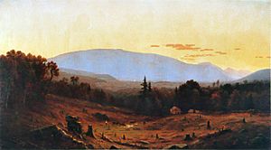
Forests and Logging History
Hunter Mountain was close to towns, so its forests were used a lot. In the mid-1800s, a man named Colonel William Edwards was very successful at harvesting hemlock bark for tanning leather. The ridge where the ski area is now was even named "Colonel's Chair" after him. The village of Hunter was briefly called Edwardsville because of his work.
Later, between 1903 and 1917, a company called Fenwick Lumber Company cut down almost all the trees on Hunter and Southwest Hunter. Because of this, it's hard to find any original forests left in the areas they logged. Some of the old roads and railroads they built are still used as hiking trails today.
Protecting the Forests
New York State created the Forest Preserve to help the mountain's forests grow back after all the logging. Starting in 1921, the state began buying the logged lands. These lands became "forever wild" under the state's rules, meaning they would be protected. By 1929, most of Hunter Mountain was protected, and new hiking trails were built.
The building of the ski area later brought new challenges. There were ideas to change state rules to allow the ski area to expand closer to the summit. However, environmental groups strongly opposed this. In 1999, Governor George Pataki declared most of the Catskill High Peaks, including Hunter, a Bird Conservation Area. This was done to protect rare bird species like the Bicknell's thrush. This decision helped stop further development near the summit.
A Famous Conversation
In 1996, a famous conversation happened during a hike up Hunter Mountain. A woman named Monica Lewinsky told a friend about a secret she had. This event was later mentioned in a well-known report about President Bill Clinton. The hike was part of a trip to a health spa near the mountain.
Hunter Mountain Today
Today, Hunter, Rusk, and Southwest Hunter mountains are part of the Hunter Mountain Wild Forest. This area is still recovering from past logging. There are plans to combine most of this land with the nearby West Kill Wilderness Area. This would create a larger protected area called the Hunter-West Kill Wilderness Area. However, the very summit of Hunter Mountain would remain a "Wild Forest" area. This allows certain activities, like using the Spruceton Trail, that aren't allowed in a strict wilderness area.
Hunter Mountain's Natural Environment
Besides logging and ski development, Hunter Mountain's forests have also been affected by forest fires. These fires were especially common on the eastern side above Stony Clove Notch. One expert, Michael Kudish, calls Hunter the "interior fire capital of the Catskills." He believes most of these fires were linked to the logging operations.
Because of these fires, the boreal forest at higher elevations on Hunter Mountain has more paper birch and red spruce trees. These trees are often the first to grow back after a disturbance, unlike balsam fir which is common on other Catskill peaks. You can also see red spruce growing with hemlock trees at lower elevations near Stony Clove Notch, which shows where a lot of hemlock bark was harvested.
If you look from a popular viewpoint over Southwest Hunter, you can see how much the forest has changed. The many small birch trees on the slopes down to Devil's Acre are from a big fire in 1903. You can also see the signs of fire damage along the long, flat part of the Devil's Path trail.
Even at a lower elevation of about 2,100 feet (640 meters) along NY 214 in Stony Clove Notch, you can find a small patch of boreal forest. This is unusual because these forests usually grow at much higher elevations in the Catskills.
Ways to Reach Hunter Mountain's Summit
There are four main ways to hike up Hunter Mountain. Most people use these marked trails. It's rare for people to just walk through the woods without a trail. Two of these routes also let you climb Southwest Hunter Mountain on the same trip, which is popular for hikers trying to complete the Catskill Mountain 3500 Club list.
Spruceton Trail: The Popular Path
The most common way to reach the summit is the blue-marked old road from the southwest, called the Spruceton Trail. Many people hike it, but it's also marked for horses and cross-country skiers in winter.
The trail starts at a parking area near the end of Spruceton Road, about 7 miles (11 km) from NY 42 in West Kill. From the start, which is 2,083 feet (635 meters) above sea level, it's a 3.4-mile (5.5 km) hike and a climb of 1,957 feet (596 meters) to the top. The parking lot even has special platforms to help riders get on their horses.
The trail heads north, following Hunter Brook for a short distance. It's a gentle climb on a somewhat rocky path until it crosses the brook on a wooden bridge. About 0.5 miles (0.8 km) from the start, you'll reach a sharp turn. This spot is often used by hikers who want to start climbing Rusk Mountain off-trail.
After these turns, the trail starts to climb more noticeably, heading northeast. It levels out at about 2,920 feet (890 meters) when it reaches Taylor Hollow, the low point between Hunter and East Rusk. This area is a wide, grassy clearing with hitching posts for horses.
The Spruceton Trail then begins its hardest part, a steady climb to the east. This section used to be very rough with lots of erosion. But in the early 2000s, the state did a lot of work to improve the trail, adding gentler turns. This made it much easier for horses.
In the next 0.5 miles (0.8 km), you'll climb 600 feet (183 meters) to a spring. There's a barrel and a hitching post here. This was also the site of the John Robb Lean-to, a popular log shelter that burned down in 2005. Camping is not allowed here until a new lean-to is built (a new one was built in 2009). The spring is great because hikers can refill their water bottles. From the rocks across from the lean-to site, you get amazing views of Rusk, West Kill, and the Spruceton Valley.
After the lean-to, you'll notice more fir and spruce trees. Around the Colonel's Chair Trail junction, you cross the 3,500-foot (1,067-meter) line, and the forest becomes a boreal forest. The trail climbs a bit more, then has long flat sections through the forest with only occasional uphill parts. This area can be muddy, especially after rain, reminding many hikers of the Adirondacks. But there are occasional views to the north from rocky spots near the trail. As you get closer to the summit, two short side trails lead to reliable springs. The road becomes noticeably more winding and steeper as it makes its final climb to the summit.
You can also make a loop hike by taking the Spruceton Trail to the yellow-marked Hunter Mountain Trail. Then, you can go down to Devil's Acre to climb Southwest Hunter. After that, you can return to the Spruceton trailhead using part of the Devil's Path and the Diamond Notch Trail.
Devil's Path and Hunter Mountain Trail
Another popular route starts from the southeast, using the Devil's Path at Stony Clove Notch. This red-marked trail starts very steeply, winding past impressive rock cliffs called the Devil's Portal. It then follows an old logging road through an area where hemlock trees are growing back. The trail becomes more typical as it levels out just under 3,500 feet (1,067 meters). This first mile (1.6 km) involves a climb of about 1,500 feet (457 meters).
The next 1.15 miles (1.85 km) is a pleasant, flat walk through areas that were heavily logged but are now covered in paper birch and red spruce. Just before the Devil's Acre Lean-to, the yellow-marked Hunter Mountain Trail branches off to the north. This trail reaches the junction at the old fire tower site after 1.35 miles (2.17 km). From there, it's 0.2 miles (0.32 km) to the summit on a flat but often wet extension of the Spruceton Trail. The total hike is about 3.7 miles (6 km) with a vertical climb of 2,060 feet (628 meters).
This route also lets you visit Southwest Hunter Mountain as a side trip. You can also reach the summit by starting the Devil's Path from the west, using either trailhead of the Diamond Notch Trail. This way, you can see the beautiful Buttermilk Falls where the Devil's Path and Diamond Notch Trail meet.
Colonel's Chair Trail from the Ski Area
The yellow-marked Colonel's Chair Trail starts at the ski area's "summit" lodge, which is about 3,300 feet (1,006 meters) high. It follows some of the ski area's snowshoe trails for about 0.75 miles (1.2 km) until it reaches state land. From there, it's a gentle 0.45-mile (0.72 km) walk through the boreal forest to the junction with the Spruceton Trail. It's then 1.2 miles (1.9 km) to the summit.
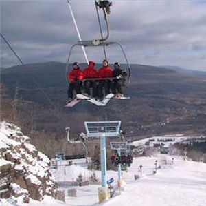
This route is probably the easiest way up Hunter Mountain. It's only 2.3 miles (3.7 km) long with a 700-foot (213-meter) climb. The ski resort even runs chairlifts to the top year-round. However, most serious hikers prefer to climb the entire mountain from the base without using the chairlift. Most people who use this route are visitors to the ski area who have rented snowshoes.
Becker Hollow Trail
The least popular way to climb Hunter Mountain is also the shortest. It's the Becker Hollow Trail, which starts along Route 214 north of Stony Clove Notch. It's only 2.05 miles (3.3 km) to the summit from here. But the climb is very steep, with a vertical ascent of 2,270 feet (692 meters). This trail is known for being a continuous uphill climb with no flat parts. You can follow it to the trail junction at the old fire tower site, or take a short path directly to the summit past a spring.
Hunter Mountain's Summit Experience
Hunter's summit is a large open area with the fire tower and an observer's cabin. You can climb the fire tower again, but the top part is usually locked unless volunteer guides are there. The cabin is locked but might become a small museum someday, like cabins on nearby Overlook Mountain and Balsam Lake Mountain.
Some hikers used to think the old fire tower site was the actual summit. But this is an optical illusion, similar to what happens at the top of Mount Davis in Pennsylvania. Hunter's summit is wide and flat, making it hard to tell the exact highest point.
There's a flat rock near the fire tower that points north and says "4040 FT" on it. This might be the true highest point. Recently, new hitching racks and a mounting platform for horses have been built or improved at the summit.
The Fire Tower's Story
A wooden fire tower was first built on the summit in 1909. This was during the time Fenwick's logging company was active. After logging ended, a steel tower replaced it in 1917. The current steel tower was built in 1953. At that time, the tower's location was moved from a smaller clearing 0.2 miles (0.32 km) east of the summit to its current spot. The old footings from the earlier tower are still visible at a trail junction, sometimes confusing hikers about the actual summit.
Fire lookouts were no longer needed after 1990, so the tower was closed. However, its stairs and top part were still easy for visitors to access, and people often climbed it for the amazing 360-degree views. Later, the New York State Department of Environmental Conservation (DEC) decided to save the tower instead of tearing it down. They raised money to fix it up and reopen it, along with four other towers in the Catskills. The goal was to teach the public about the Forest Preserve. In 1997, the tower was added to the National Register of Historic Places, which protects important historical sites. After renovations, it reopened to the public in 2000. The small room at the very top of the tower, where rangers used to work, is now locked and boarded up.
 | John T. Biggers |
 | Thomas Blackshear |
 | Mark Bradford |
 | Beverly Buchanan |


