Catskill High Peaks facts for kids

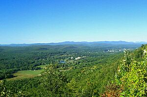
The Catskill High Peaks are special mountains in the Catskill Mountains of New York State. To be a "High Peak," a mountain must be taller than 3,500 ft (1,067 m). Also, its top must be at least one-half mile (0.8 km) away from another peak, or drop at least 250 ft (76.2 m) before the next peak. These mountains are usually rounded and covered in trees.
Unlike the Adirondack High Peaks, the Catskill High Peaks are spread out more. Most of them are inside the Catskill Park's special boundary, called the Blue Line. Only two, Bearpen and Vly, are outside this line.
Contents
Why are 3,500 Feet Important?
The height of 3,500-foot (1,067 m) was chosen in the 1950s. A man named Dan Smiley and his friends were birdwatching. They were looking for a rare bird called the Bicknell's thrush. This bird likes to build its nests in the cool, northern-like forests found above 3,500 ft (1,067 m) in the Catskills. They made a list of peaks that were this tall.
About ten years later, hikers who enjoyed "peak bagging" started the Catskill Mountain 3500 Club. This club is like the famous Adirondack 46ers. Their goal is to climb all 35 High Peaks. When the club started, there were 34 peaks. "Southwest Hunter" was added in 1992.
To join the club, you must climb all 35 peaks. Some peaks do not have trails, so you have to find your own way through the woods. After climbing all of them, you also need to climb Slide, Blackhead, Balsam, and Panther mountains again during winter.
Protecting the High Peaks
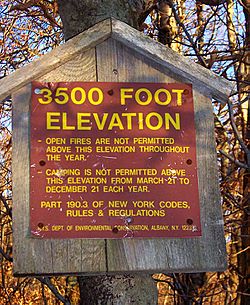
Today, the New York State Department of Environmental Conservation (DEC) has special rules for lands above 3,500 ft (1,067 m). This is because the plants and animals in these high areas are very delicate. For example, you can only camp in these areas in emergencies. Open fires are also not allowed.
In 1999, Governor George Pataki made almost all these areas "bird conservation areas." This helps protect the Bicknell's thrush and other special birds that come to nest there each spring.
What are the Catskill High Peaks?
The exact heights of many Catskill High Peaks have not been officially measured recently. The last surveys were done in the 1940s. For some peaks, their height is shown on maps with a plus (+) sign. This means they are at least as tall as the highest 20 feet (6.096 m) contour line on the map.
Here is a list of the 35 Catskill High Peaks:
| Peak Name | Height in Feet | Height in Meters | Rank |
|---|---|---|---|
| Slide Mountain+ | 4180 | 1275 | 1 |
| Hunter Mountain+ | 4040 | 1230 | 2 |
| Black Dome+ | 3980 | 1210 | 3 |
| Thomas Cole+ | 3940 | 1200 | 4 |
| Blackhead+ | 3940 | 1200 | 5 |
| West Kill+ | 3880 | 1180 | 6 |
| Graham Mountain | 3868 | 1179 | 7 |
| Doubletop Mountain+ | 3860 | 1180 | 8 |
| Cornell Mountain+ | 3860 | 1180 | 9 |
| Table Mountain | 3847 | 1173 | 10 |
| Peekamoose Mountain | 3843 | 1171 | 11 |
| Plateau Mountain+ | 3840 | 1170 | 12 |
| Sugarloaf Mountain+ | 3800 | 1160 | 13 |
| Wittenberg Mountain+ | 3780 | 1150 | 14 |
| "Southwest Hunter"+ | 3740 | 1140 | 15 |
| Balsam Lake Mountain | 3723 | 1135 | 16 |
| Lone Mountain | 3721 | 1134 | 17 |
| Panther Mountain+ | 3720 | 1130 | 18 |
| Big Indian Mountain+ | 3700 | 1130 | 19 |
| Friday Mountain | 3694 | 1126 | 20 |
| Rusk Mountain+ | 3680 | 1127 | 21 |
| Kaaterskill High Peak | 3655 | 1114 | 22 |
| Twin Mountain+ | 3640 | 1109 | 23 |
| Balsam Cap | 3623 | 1104 | 24 |
| Fir Mountain+ | 3620 | 1103 | 25 |
| North Dome | 3610 | 1100 | 26 |
| Eagle Mountain+ | 3600 | 1100 | 27 |
| Balsam Mountain+ | 3600 | 1100 | 28 |
| Bearpen Mountain | 3600 | 1100 | 29 |
| Indian Head | 3573 | 1089 | 30 |
| Sherrill Mountain+ | 3540 | 1080 | 31 |
| Halcott Mountain | 3537 | 1078 | 32 |
| Vly Mountain | 3529 | 1076 | 33 |
| Windham High Peak | 3524 | 1074 | 34 |
| Rocky Mountain | 3508 | 1069 | 35 |
- The name "Southwest Hunter" is not official. It refers to a peak between Hunter and West Kill.
- The "Bearpen Mountain" on this list is not the one shown on some maps. It is a higher area about one-half mile (0.8 km) southeast in Greene County.
Could There Be More High Peaks?
Some people wonder if there are other peaks that might be tall enough to be High Peaks. This is because old surveys were not as exact as modern ones.
- An unnamed peak west of Thomas Cole, sometimes called "Camel's Hump," is taller than 3,520-foot (1,070 m). It is also far enough from Thomas Cole. But it is not yet considered a High Peak.
- Two peaks in the western Catskills, around 3,480 ft (1,061 m) tall, might be High Peaks if measured with new technology. GPS readings on some peaks have shown them to be taller than maps say.
- One of these is Mill Brook Ridge. If it were found to be over 3,500 ft (1,067 m), it would be the westernmost High Peak.
- The other is "East Schoolhouse Mountain." This is an unofficial name for a peak between Balsam Lake and Graham. Some computer data suggests it might just be over the limit.
- There is also a small 3,500-foot (1,100 m) contour east of West Kill's summit. But people who have explored that area doubt it really exists.
 | Bessie Coleman |
 | Spann Watson |
 | Jill E. Brown |
 | Sherman W. White |


