Mount Sherrill facts for kids
Quick facts for kids Mount Sherrill |
|
|---|---|

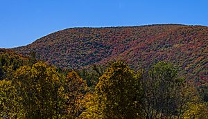
Sherrill from Spruceton Road east of West Kill
|
|
| Highest point | |
| Elevation | 3,550 ft (1,080 m) |
| Prominence | 540 ft (160 m) |
| Listing | Catskill High Peaks 31st |
| Geography | |
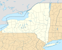
| Location | Hunter-West Kill Wilderness, Catskill Forest Preserve, Greene County, New York |
| Parent range | Central Catskills |
| Topo map | USGS Lexington |
| Climbing | |
| Easiest route | Hike |
Mount Sherrill is a mountain located in Greene County, New York. It is part of the beautiful Catskill Mountains. This mountain was named after a person called Eliakim Sherrill.
Mount Sherrill has other mountains nearby. To its east, you'll find North Dome. To its west, there is Balsam Mountain.
Contents
Where the Water Goes
Mount Sherrill is part of the Hudson River's watershed. This means all the rain and snow that falls on the mountain eventually flows into the Hudson River. The Hudson River then empties into New York Bay.
Water Flow from Different Sides
- Water from the northern parts of Mount Sherrill flows into Bennett Brook and Newton Brook.
- These brooks then join the West Kill.
- The West Kill flows into Schoharie Creek, then into the Mohawk River, and finally into the Hudson River.
- Water from the western side of Mount Sherrill goes into Bushnellsville Creek.
- This creek then flows into Esopus Creek, which also joins the Hudson River.
- The southeastern side of Mount Sherrill drains through Peck Hollow.
- This water also flows into Esopus Creek.
Exploring Mount Sherrill
Mount Sherrill is located inside the Westkill Mountain Wilderness Area. This area is part of New York's amazing Catskill State Park.
Hiking Trails
Right now, there isn't a marked hiking trail that goes over Mount Sherrill. However, people have thought about extending the famous Devil's Path hiking trail from West Kill Mountain to include Mount Sherrill. This would make it easier for hikers to explore this part of the Catskills.
 | DeHart Hubbard |
 | Wilma Rudolph |
 | Jesse Owens |
 | Jackie Joyner-Kersee |
 | Major Taylor |


