
Balsam Mountain (Ulster County, New York) facts for kids
Quick facts for kids Balsam Mountain |
|
|---|---|

Balsam seen from Route 28 to the northeast
|
|
| Highest point | |
| Elevation | 3,610 ft (1,100 m) |
| Prominence | 580 ft (180 m) |
| Listing | Catskill High Peaks #28 |
| Geography | |
| Location | Oliverea, New York, U.S. |
| Parent range | Catskill Mountains |
| Topo map | USGS Shandaken, Seager |
| Geology | |
| Age of rock | 250–350 mya |
| Mountain type | Dissected plateau |
| Climbing | |
| Easiest route | Trail |
Balsam Mountain is one of the highest mountains in the Catskill Mountains of New York State. Its exact height isn't known for sure, but it's usually listed as about 3,600 feet (1,100 m) tall. This mountain is located in western Ulster County. It sits on a special line called a drainage divide, which means water on one side flows towards the Hudson River and water on the other side flows towards the Delaware River.
Most of Balsam Mountain is protected land. It's part of the state Forest Preserve and is managed by the New York State Department of Environmental Conservation. This area is also part of the Big Indian-Beaverkill Range Wilderness Area within the Catskill Park. Only a small part of the very top of the mountain is on private land.
Balsam Mountain is a popular spot for hikers. Many people who want to join the Catskill Mountain 3500 Club come here. To join this club, hikers must climb 35 peaks in the Catskills. Balsam is one of four peaks they need to climb twice, including at least once in winter! A main trail called the Pine Hill-West Branch Trail goes right over the top of Balsam Mountain. Hikers usually start their climb from the Oliverea-Mapledale Trail, which connects to the main trail near the summit. There are different ways to reach the top, including a loop trail using the Mine Hollow Trail. One path, from McKenley Hollow, is known for being the steepest trail section on any Catskill High Peak.
Contents
Where is Balsam Mountain Located?
Balsam Mountain is part of a mountain range that doesn't have an official name. This range helps separate the water flowing towards different rivers. Balsam is the second mountain from the north in this range, after Belleayre Mountain. It's also the northernmost peak that is taller than 3,500 feet (1,100 m), which is the height needed to be called a "High Peak." A ridge about two miles (3.2 km) long connects Balsam to Belleayre. South of Balsam, the ridge turns southwest and connects to Haynes Mountain, which is about 3,420 feet (1,040 m) tall.
The very top of Balsam Mountain is a small bump at the southern end of a narrow ridge. This ridge is about 2,000 feet (610 m) long and has a slight dip between the true summit and a "false summit" to the north.
On the east side of the mountain, the slopes drop steeply down to Big Indian Hollow. This valley is where the Esopus Creek begins, about 1,200 feet (370 m) above sea level. Some areas on the southeast side are less steep, around 2,200 to 2,700 feet (670 to 820 m) high. Many smaller streams flow down these steep valleys, joining together in a fan shape from Lost Clove in the northeast to McKenley Hollow in the southeast.
The valleys on the west side are also steep but not as many. They meet at a higher elevation, around 2,100 feet (640 m). A narrow valley carries these streams down to Dry Brook, which flows into the East Branch of the Delaware River. The northernmost valley is called Mine Hollow. It got its name from an old, unsuccessful attempt to find gold there. The larger valley it branches off from is often called Rider Hollow.
How Was Balsam Mountain Formed?
Like the rest of the Catskill Mountains, Balsam Mountain is a dissected plateau. This means it wasn't formed by huge pushes of rock layers. Instead, it was created by streams slowly carving out valleys in a raised area about 350 million years ago. The rocks that make up Balsam Mountain are mostly shale and sandstone from the Devonian and Silurian periods.
Later, during the Ice Ages, huge glaciers shaped the mountain's slopes, making them even steeper. The melting ice from these glaciers also helped form the Esopus Creek.
The steeper slopes and deeper valley on the east side of Balsam Mountain are quite unique. The rocks in the Esopus Creek area are much more cracked and broken than in other parts of the Catskills. The Esopus Creek and its smaller stream, Woodland Creek, almost make a full circle around Panther Mountain to the east. Scientists like Yngvar Isachsen have found strong clues that the entire Panther Mountain area might be the inside-out shape of an ancient meteor crater. This crater formed when a meteor hit the Earth long ago, when the Catskills were a river delta at the edge of an ancient inland sea. The edges of the crater were more easily worn away by water, creating a deeper valley for the Esopus Creek.
What Plants and Animals Live on Balsam Mountain?
Balsam Mountain's slopes are covered with the types of forests you'd expect to see in the Catskills at different heights. Lower down, you'll find "northern hardwoods" like beech, birch, and maple trees, with some cherry and mountain ash. Closer to the streams at the bottom, you might see trees like oaks, a few American chestnuts that survived a disease, and shagbark hickory trees.
As you go higher up the mountain, the northern hardwood trees become smaller and more twisted, especially on the ridges. Near the very top of the mountain, you'll start to see "boreal" trees like balsam fir and red spruce. These trees form small groups but don't cover the whole summit like they do on even taller peaks. In the 1970s, a forest expert named Michael Kudish found some fir trees on the north slope, but they have since died, possibly because of too much deer eating their leaves. There's also a large group of tall hemlock trees in Mine Hollow.
Most of the forest higher up on the mountain has never been cut down or used by people. This means it's "old-growth forest" – a very special and untouched natural area. Only a small part of the north slope shows signs of having been logged in the past.
The forests on Balsam Mountain are home to many different animals typical of the Catskills. Large mammals include black bears and white-tailed deer. You can also find smaller animals like porcupines and chipmunks, as well as salamanders and toads.
A Look Back: Balsam Mountain's History
The Iroquois tribes who first lived in the Hudson Valley didn't often go high into the mountains, except for hunting. The first European settlers, descendants of Dutch and English colonists, started building small farms near the mountain around 1805. Some farms were even on the lower slopes of the mountain. Maps from 1900 show a road going up a ridge to a cabin called Platt's Cabin, quite high up the mountain.
Balsam Mountain used to have many more hemlock trees. Most of these were cut down by people called "tanners" who used the bark to make leather. Roads built to reach these hemlock trees can still be found in McKenley Hollow.
In 1885, a law was passed that included the Catskill counties in the newly created Forest Preserve. This meant that land that had been abandoned by loggers and tanners, and which the county now owned, was given to the state. The rule was that these lands would stay "forever wild," meaning no more trees could be cut down. In 1894, this rule became an even stronger part of the state's constitution.
Because of these rules, the state bought most of the land it now owns on Balsam Mountain in 1918. This is about three-quarters of the mountain. By 1931, a trail that had been built on Belleayre Mountain for tourists was extended over Balsam Mountain and became a state-maintained trail. Other trails, like the Oliverea-Mapledale trail, were also built around this time.
In the 1980s, the large area of state land west of Esopus Creek, including Balsam Mountain, was named a "wilderness area." This means the state's Department of Environmental Conservation (DEC) manages the land to keep it as natural as possible, with minimal human impact. Because of this, some old lean-tos (simple shelters) in McKenley and Rider hollows were removed or not replaced after they burned down.
Hiking Balsam Mountain
Hikers usually start their climb of Balsam Mountain from the south. They take the Oliverea-Mapledale Trail from either McKenley Hollow or Rider Hollow. This trail leads to the Pine Hill-West Branch Trail junction, which is about 3,030 feet (920 m) high. From there, they climb to the summit. The path from McKenley Hollow is often used because it's closer to NY 28, a main road in the Catskills. The path from Rider Hollow is farther from main roads but is considered more scenic. You can even combine it with the Mine Hollow Trail to make a loop hike.
The McKenley Hollow trail starts at a parking lot about 1 mile (1.6 km) west of County Route 47 in Oliverea. This spot is about 1,600 feet (490 m) above sea level. The Oliverea-Mapledale Trail follows red markers along the brook, passing the trail register and the old sites of lean-tos. It starts gently, following an old wood road, and then climbs a bit more steeply.
A section of stone steps on the trail marks a very steep climb. Here, the trail goes up over 450 feet (140 m) in just 0.25 mile (400 m). This 35% slope is the steepest trail section in the Catskills! After this tough climb, the trail levels out and reaches the junction with the main trail.
On the Rider Hollow side, the trail starts at a higher elevation, about 2,000 feet (610 m). The first mile is fairly flat, following the brook and passing the site of an old lean-to and a natural spring. The yellow-marked Mine Hollow Trail branches off to the left about 0.4 miles (640 m) from the parking lot. Almost a mile later, the trail crosses another stream and starts to climb steeply, going up 750 feet (230 m) in the next 0.8 miles (1.3 km). After passing another spring, the trail levels out and reaches the junction.
From the junction, the blue-marked Pine Hill-West Branch Trail climbs the last 570 feet (170 m) to the summit. This part is about 0.75 miles (1.21 km) long. Just before the summit, at 3,500 feet (1,100 m), a sign tells hikers about special rules for camping above that height (only allowed in winter) and that open fires are not allowed. Soon after, the trail crosses a small part of private land. The actual highest point of the mountain is a small mound less than 100 feet (30 m) northeast of the trail, in an open forest.
The total climb from McKenley Hollow is about 2,000 feet (610 m) over 2.15 miles (3.46 km). From Rider Hollow, it's about 1,600 feet (490 m) over 1.95 miles (3.14 km).
After the summit, the trail drops down slightly. In the dip between the two summits, a small rocky spot offers views to the northwest. You can see the hamlet of Big Indian and other High Peaks like West Kill, Hunter, and Plateau mountains. This is the only view you can get from the mountain when the leaves are on the trees.
Hikers doing the Mine Hollow loop from Rider Hollow continue over the lower northern summit. The trail then drops about 700 feet (210 m) through a rocky area down the north slope of Balsam to the Mine Hollow Trail junction. This is about 1.3 miles (2.1 km) north of the true summit. That trail goes steeply down at first through more rocks, then levels off in a hemlock forest. A mile (1.6 km) from the junction, it reaches the Oliverea-Mapledale Trail. The total length of this loop hike is 5.2 miles (8.4 km).
Backpackers who stay overnight also climb Balsam Mountain as part of longer trips along the Pine Hill-West Branch Trail. From the northern end in Pine Hill, it's about 4.3 miles (6.9 km) over Belleayre Mountain's southern summit to reach Balsam. The southern end of the trail is near Frost Valley YMCA, about 9.9 miles (15.9 km) away. This longer route involves climbing Big Indian, Eagle, and Haynes mountains before reaching Balsam.
Images for kids
-
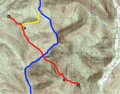
Map of Balsam Mountain, with trails indicated in blaze colors

