Panther Mountain (New York) facts for kids
Quick facts for kids Panther Mountain |
|
|---|---|

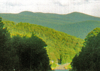
Panther from the west, along Route 28 near Highmount
|
|
| Highest point | |
| Elevation | ~3,720 feet (~1,134 m) |
| Prominence | 980 feet (300 m) |
| Listing | Catskill High Peaks 18th |
| Geography | |
| Location | Shandaken, New York, U.S. |
| Parent range | Catskills |
| Topo map | USGS Shandaken |
| Climbing | |
| Easiest route | Trail |
Panther Mountain is a cool mountain in the Catskills in New York, U.S.. It's about 3,720 feet (1,134 meters) tall, making it the 18th highest peak in the range. Scientists think this mountain might be sitting on top of an ancient meteorite impact crater!
Panther Mountain is a very popular spot for hikers. It's close to Slide Mountain, which is the tallest peak in the Catskills. Plus, it has amazing views from its top and from a nearby spot called Giant Ledge. If you want to join the Catskill Mountain 3500 Club, you need to climb Panther Mountain twice, and at least one of those times has to be in winter!
| Top - 0-9 A B C D E F G H I J K L M N O P Q R S T U V W X Y Z |
What's in a Name?
No one is really sure how Panther Mountain got its name. Long ago, there might have been panthers living in the area. But you won't find any panthers in the Catskills today.
Mountain Layout and Location
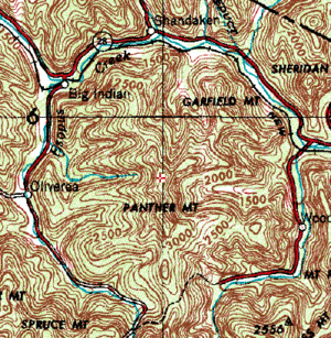
Panther Mountain looks like a long ridge in the middle of a big circle. This circle is mostly formed by two creeks: Esopus Creek and Woodland Creek. The north ridge of Slide Mountain starts right where Panther Mountain's ridge ends.
The mountain is part of New York's Forest Preserve. This means it's protected land. Today, it's inside the Slide Mountain Wilderness Area, which is part of the Catskill Park. The state's Department of Environmental Conservation looks after this area.
Natural Wonders of Panther Mountain
The Mystery of the Buried Crater
The way the two creeks circle Panther Mountain is very unusual. Most mountains have streams that look like tree branches. But around Panther, they form a nearly perfect circle. This made scientists wonder if something special was hidden beneath the surface.
In the 1940s, a geologist named George Chadwick thought this circular shape might be caused by gas pushing up from below. A company even drilled a deep well, about 6,000 feet (1.8 km) down, looking for natural gas. They found some, but not enough to make money, so they stopped.
Later, in the 1970s, another geologist named Yngvar Isachsen thought the circular stream pattern might mean there was a impact crater buried underground. He noticed that the rocks in the creek bed were broken into much smaller pieces than usual. He thought this might be because a crater wall was underneath, causing the ground to settle and crack over time.
In the 1990s, Isachsen spent more time studying his idea. He knew that impact craters often have a mound of rock in the middle. This mound has less dense rock, which means it has a slightly weaker gravitational pull. Isachsen took a special tool called a gravimeter up the mountain. He found that the gravity on Panther Mountain was indeed a little weaker than on other mountains nearby. This supported his crater theory!
To prove his idea for sure, Isachsen needed to find direct proof of a meteorite strike. He found old rock samples from the gas well drilled years ago. When his students looked closely at these samples, they found tiny, round pieces of iron. Isachsen believed these were clear signs of a meteorite impact.
However, other scientists asked him to look even closer. They wondered if the iron pieces could have come from somewhere else. So, in 1999, Isachsen examined tiny quartz crystals in the samples. He found special marks on them called "shock lamellae." These marks can only be made by a powerful impact, like a meteorite hitting the Earth. Scientists from Canada confirmed his discovery.
Scientists now believe the meteorite hit Earth about 375 million years ago. Back then, the Catskills area was mostly a shallow sea or a river delta. The crater is about 2,640 feet (800 meters) below the surface and is 6 miles (10 km) wide. It's right under Panther Mountain! The meteorite that caused it was probably about half a mile (1 km) wide. It hit with a force like 11 trillion tons of TNT!
Isachsen also thinks there might be lots of oil and gas deep under the mountain. These are often found near ancient buried impact craters.
In 2004, a space probe called Mars Express found a similar circular plateau on Mars. It's like Panther Mountain, but on another planet!
Forests and Trees
The forests on Panther Mountain are typical for the Catskills. On the lower parts, you'll find northern hardwood trees like beech, birch, and maple. As you climb higher, above 3,500 feet (1,067 meters), you'll see boreal forests with balsam fir and red spruce trees.
In the 1800s, people cut down many trees on the lower slopes, especially hemlock trees for their bark. But the upper parts of the mountain still have first growth trees, meaning they have never been cut down. A forest expert named Michael Kudish says there's a rare group of untouched spruce trees near the top. There are also two open areas on a spot called Beech Flat where no trees grow because there's no soil.
People and Panther Mountain
We don't know who first climbed Panther Mountain because old records are not very clear. People used to farm lower down on Panther Mountain than on other Catskill peaks because the slopes were very steep at the bottom. Later, logging went higher up the mountain, especially near towns like Big Indian and Phoenicia, because they had train stations nearby.
The railroad also led to another industry: bluestone quarrying. Bluestone is a type of rock used for building. Experts have found several bluestone quarries along the northern edge of the mountain.
The main hiking trail across the mountain, called the Fox Hollow-Panther-Giant Ledge Trail, was built in 1935. A lean-to (a simple shelter) was built along the trail the next year.
Hiking Panther Mountain
Panther Mountain has a main trail called the Fox Hollow-Panther-Giant Ledge Trail (GP). It runs from north to south. Most hikers use this trail to reach the top.
The southern way up is shorter and more popular because of the amazing views from Giant Ledge. The northern way also has some nice views. Some experienced hikers even do the whole 7.5-mile (12 km) GP trail as an overnight trip, staying at one of the campsites along the way.
Climbing from the South
Hikers usually park at a lot about 2,100 feet (640 meters) high. From there, you take the P-EB trail for about 0.7 miles (1.1 km) uphill to meet the GP trail.
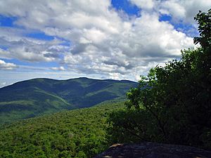
Once on the GP trail, you'll walk about 0.6 miles (1 km) to the base of Giant Ledge. There's a good spring here for fresh water. Then, you climb about 0.15 miles (240 meters) up the steep, rocky south side of the ledge. At 3,200 feet (975 meters), you'll find many viewpoints with incredible sights! You can see the Burroughs Range (Slide, Wittenberg, and Cornell mountains), the valley of Woodland Creek, and even a small part of the Ashokan Reservoir. There are also more campsites here.
The trail stays on the ledge for about 0.3 miles (500 meters), then drops down. The climb up Panther Mountain itself begins here. The trail winds up the mountain's south slope. About 0.75 miles (1.2 km) from the ledge, a short side trail leads to another great viewpoint of the Burroughs Range. A bit further, you'll pass a sign marking 3,500 feet (1,067 meters) in elevation. Above this line, you can't have open fires, and camping is only allowed in winter because the environment is very delicate. The trail then levels out, and it's almost 0.5 miles (1 km) more to the small rocky spot with a view to the northeast that marks the summit.
This southern route is about 3.2 miles (5.1 km) long to the top. You climb about 1,920 feet (585 meters) in total.
Climbing from the North
The northern end of the GP trail starts at a small parking area at the end of Fox Hollow Road, about 1,420 feet (433 meters) high. About 0.4 miles (640 meters) from the start, a short side trail leads to the Fox Hollow lean-to and a reliable spring.
The trail then starts to climb the long ridge of Panther Mountain. After about 2.7 miles (4.3 km), you'll reach the first "false summit" (a high point that looks like the top but isn't). You'll go down a bit, then climb again to a second false summit about 0.6 miles (1 km) further south. Along the way, you'll get great views of peaks to the west, like Balsam, Fir, and Big Indian. It's another 1.2 miles (1.9 km) and a steeper climb to the actual summit.
This northern route is about 4.9 miles (7.9 km) long. You climb about 2,450 feet (747 meters) in total.
- Isachsen, Y.W., Wright, S.F., and Revetta, F.A., 1994, The Panther Mountain circular feature possibly hides a buried impact crater. Northeastern Geology, v. 16, no. 2, p. 123–136.
 | Claudette Colvin |
 | Myrlie Evers-Williams |
 | Alberta Odell Jones |


