Shandaken, New York facts for kids
Quick facts for kids
Shandaken, New York
|
|
|---|---|

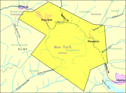
US Census Map
|
|

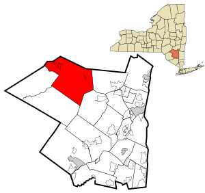
Location in Ulster County and the state of New York.
|
|
| Country | United States |
| State | New York |
| County | Ulster |
| Area | |
| • Total | 119.84 sq mi (310.39 km2) |
| • Land | 119.78 sq mi (310.24 km2) |
| • Water | 0.06 sq mi (0.15 km2) |
| Elevation | 1,348 ft (411 m) |
| Population
(2020)
|
|
| • Total | 2,866 |
| • Density | 23.915/sq mi (9.2335/km2) |
| Time zone | UTC-5 (Eastern (EST)) |
| • Summer (DST) | UTC-4 (EDT) |
| ZIP code |
12480
|
| Area code(s) | 845 |
| FIPS code | 36-66597 |
| GNIS feature ID | 0979484 |
Shandaken is a small town located in Ulster County, New York. It sits on the northern border of the county, northwest of Kingston. In 2020, about 2,866 people lived here. The name "Shandaken" is thought to come from an old Esopus Native American phrase. It means "land of rapid waters" or "place of the hemlocks."
Contents
History of Shandaken
Shandaken was first settled around the time of the American Revolution. It officially became a town in 1804. This happened when it was created from a part of the Town of Woodstock.
Over the years, Shandaken's borders changed a few times. In 1809, it gained land from the Town of Neversink. Later, some of Shandaken's land was used to form other towns. These towns included Denning, Hardenburgh, and Olive.
By the late 1800s, tourism became very important to Shandaken. People started visiting the area for its beautiful nature. Today, tourism is still a big part of the town's economy. The Mount Tremper Fire Observation Station is a historic site in Shandaken. It was added to the National Register of Historic Places in 2001.
Geography and Nature
Shandaken covers about 119.8 square miles (310.39 square kilometers). Most of this area is land, with a very small amount of water.
The town is located entirely within the Catskill Park. This means it is a very mountainous area. Slide Mountain, the highest peak in the Catskill Mountains, is found here. It stands at 4,180 feet (1,274 meters) tall. Several other high peaks over 3,500 feet (1,067 meters) are also in Shandaken.
The northern edge of Shandaken borders Greene County. The western edge borders Delaware County. The Esopus Creek is an important waterway that flows through the town.
People of Shandaken
| Historical population | |||
|---|---|---|---|
| Census | Pop. | %± | |
| 1820 | 1,043 | — | |
| 1830 | 966 | −7.4% | |
| 1840 | 1,455 | 50.6% | |
| 1850 | 2,307 | 58.6% | |
| 1860 | 2,430 | 5.3% | |
| 1870 | 2,751 | 13.2% | |
| 1880 | 2,829 | 2.8% | |
| 1890 | 3,170 | 12.1% | |
| 1900 | 3,053 | −3.7% | |
| 1910 | 2,657 | −13.0% | |
| 1920 | 2,372 | −10.7% | |
| 1930 | 2,066 | −12.9% | |
| 1940 | 1,875 | −9.2% | |
| 1950 | 1,887 | 0.6% | |
| 1960 | 2,078 | 10.1% | |
| 1970 | 2,593 | 24.8% | |
| 1980 | 2,912 | 12.3% | |
| 1990 | 3,013 | 3.5% | |
| 2000 | 3,235 | 7.4% | |
| 2010 | 3,085 | −4.6% | |
| 2020 | 2,866 | −7.1% | |
| U.S. Decennial Census 2020 | |||
In 2020, the census showed that 2,866 people lived in Shandaken. There were 1,473 households. Most people living in Shandaken are White (about 94.65%). Other groups include African American, Native American, and Asian people. About 3.06% of the population is Hispanic or Latino.
About 20.2% of the people in Shandaken are under 18 years old. The median age in the town is 45 years. This means half the people are younger than 45, and half are older.
The average income for a household in Shandaken was $55,139. For families, the average income was $80,372.
Important Services
Shandaken provides important services to its residents. The town has a paramedic ambulance service. This service also helps people in nearby towns like Olive, Lexington, and Westkill.
The town also has its own police department. It is located in the hamlet of Shandaken. The police department has both full-time and part-time officers. The Ulster County sheriff's office also has a small office in the town.
The Shandaken Justice Court handles legal matters. These include traffic tickets, minor criminal cases, and civil cases. Traffic court is usually held every Tuesday.
Places to See in Shandaken
Shandaken is made up of several smaller communities called hamlets. Each has its own unique features:
- Allaben – This hamlet is east of Shandaken village. It is where the town government offices are located.
- Beechford – You can find this hamlet in the southeastern part of the town.
- Big Indian – This hamlet is southwest of Shandaken village. It is in the beautiful Big Indian Valley.
- Bushnellsville – This hamlet is near the northern border of the town.
- Chichester – Located in the eastern part of town, Chichester was founded in 1863. It used to be known for making furniture.
- Highmount – This area is northwest of Pine Hill. It was once called "Summit."
- Mt. Pleasant – This hamlet is in the eastern part of the town. It was previously known as "Longyear."
- Mt. Tremper – Found near the eastern town line. The Camp Wapanachki is a historic site here.
- Oliverea – This hamlet was founded in 1886. It is in the southern part of the town. The Winnisook Club is located here, near Winnisook Lake.
- Panther Mountain – This mountain is unique because it is shaped like a circle. Scientists believe it was formed by a meteor hitting the Earth long ago.
- Phoenicia – This hamlet in the eastern part of town was important for early tourism. It was the first community to get a railroad and build hotels for visitors.
- Pine Hill – This hamlet is in the western part of the town.
- Shandaken – This is the main hamlet in the north-central part of the town.
- Slide Mountain – This is the highest point in the entire Catskill Mountains. It offers amazing views.
- Woodland Valley – This hamlet is in the southeastern part of the town. It is home to the Roxmor Colony.
See also
 In Spanish: Shandaken para niños
 | Audre Lorde |
 | John Berry Meachum |
 | Ferdinand Lee Barnett |

