Hardenburgh, New York facts for kids
Quick facts for kids
Hardenburgh, New York
|
|
|---|---|

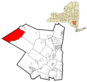
Location in Ulster County and the state of New York.
|
|
| Country | United States |
| State | New York |
| County | Ulster |
| Area | |
| • Total | 81.02 sq mi (209.85 km2) |
| • Land | 80.79 sq mi (209.24 km2) |
| • Water | 0.23 sq mi (0.61 km2) |
| Elevation | 2,864 ft (873 m) |
| Population
(2020)
|
|
| • Total | 221 |
| • Density | 2.728/sq mi (1.0531/km2) |
| Time zone | UTC-5 (Eastern (EST)) |
| • Summer (DST) | UTC-4 (EDT) |
| FIPS code | 36-32116 |
| GNIS feature ID | 0979046 |
Hardenburgh is a small town located in the western part of Ulster County, New York, United States. In 2020, about 221 people lived there. The town is found within the beautiful Catskill Park.
Contents
History of Hardenburgh
Hardenburgh was created in 1859. It was formed from parts of two other towns, Denning and Shandaken. The town was named after Johannes Hardenbergh, who was an important landowner in the area.
A Unique Tax Protest
Between 1976 and 1983, many people in Hardenburgh became "ministers" of the Universal Life Church. This church allowed people to become ministers by mail. More than half of the town's residents joined, including farmers and loggers.
They did this as a way to protest very high property taxes. They were upset because many large areas of land in the town were owned by groups that didn't have to pay taxes. These included a Zen Buddhist center, the Boy Scouts, and a group of Tibetan monks.
The residents hoped that by becoming ministers, their own land might also be free from taxes. However, in 1982, a court decided that people could only get tax breaks if their land was used only for church activities.
Historic Places and Town Life
Several important places in Hardenburgh are listed on the National Register of Historic Places. These include the Balsam Lake Mountain Fire Observation Station, Coykendall Lodge, and the Grant Mills Covered Bridge.
Hardenburgh is mostly a place where people live. In the 1990s, the town had only one general store. In 1992, the town created its first rules about how land could be used, called a zoning ordinance.
Geography and Mountains
Hardenburgh is the westernmost town in Ulster County. It is located deep within the Catskill Mountains. The town covers about 81.5 square miles (211 square kilometers). Most of this area is land, with a small amount of water.
Rugged Landscape
The town is known for its rugged and rocky landscape. It has many mountain peaks, valleys, and forests. You can also find various lakes, streams, and glens here. Some of the highest peaks in the Catskills are within Hardenburgh, such as Graham Mountain, Balsam Mountain, and Eagle Mountain.
Because of the mountains, the only direct way to get to the rest of Ulster County from Hardenburgh is by hiking trails. If you want to drive, you have to go through neighboring Sullivan or Delaware counties.
Dividing Ridge
A mountain called Dry Brook Ridge actually divides the town into two parts.
- The northern part, in the Dry Brook valley, uses the ZIP code and phone services of Arkville, a nearby village in Delaware County.
- The southern part includes the start of the famous Beaver Kill trout stream. This area is more connected to Lew Beach in Sullivan County.
Alder Lake is a 45-acre (18-hectare) lake in the town. It was created in the 1900s.
Population and People
| Historical population | |||
|---|---|---|---|
| Census | Pop. | %± | |
| 1860 | 505 | — | |
| 1870 | 628 | 24.4% | |
| 1880 | 801 | 27.5% | |
| 1890 | 784 | −2.1% | |
| 1900 | 722 | −7.9% | |
| 1910 | 598 | −17.2% | |
| 1920 | 420 | −29.8% | |
| 1930 | 313 | −25.5% | |
| 1940 | 326 | 4.2% | |
| 1950 | 284 | −12.9% | |
| 1960 | 252 | −11.3% | |
| 1970 | 239 | −5.2% | |
| 1980 | 280 | 17.2% | |
| 1990 | 204 | −27.1% | |
| 2000 | 208 | 2.0% | |
| 2010 | 238 | 14.4% | |
| 2020 | 221 | −7.1% | |
| U.S. Decennial Census 2020 | |||
In 2000, there were 208 people living in Hardenburgh. There were 95 households and 57 families. The population density was about 2.6 people per square mile. Most of the people living in the town were White (96.15%).
About 20% of the households had children under 18. The average household had about 2 people. The median age in the town was 47 years old. This means half the people were younger than 47 and half were older.
The median income for a household was $35,278. This is the middle income for all households. About 13.2% of the population lived below the poverty line.
Communities and Locations
Hardenburgh has several small communities and locations:
- Beaver Kill – This is a stream found in the southern part of the town.
- Belle Ayre (or "Belleayre") – A small community located in the northwestern part of the town.
- Hardenburgh – This is a community also located in the southern part of the town, near the Beaver Kill stream.
- Mapledale – Another small community in the northwestern part of the town.
- Seager – A community located in the southeastern section of the town.
- Turnwood – A community located in the western end of the town. It is on the Beaver Kill and Route 54.
See also
 In Spanish: Hardenburgh para niños
 | Laphonza Butler |
 | Daisy Bates |
 | Elizabeth Piper Ensley |


