Balsam Lake Mountain Fire Observation Station facts for kids
Quick facts for kids |
|
|
Balsam Lake Mountain
Fire Observation Station |
|

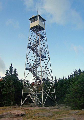
Tower in 2008
|
|
| Location | Summit of Balsam Lake Mountain, Hardenburgh, New York |
|---|---|
| Nearest city | Kingston, New York |
| Area | 10.9 acres (4.4 ha) |
| Built | 1930 |
| Architect | Aermotor Corporation |
| MPS | Fire Observation Stations of New York State Forest Preserve MPS |
| NRHP reference No. | 01001038 |
| Added to NRHP | September 23, 2001 |
The Balsam Lake Mountain Fire Observation Station is a special place located at the very top of Balsam Lake Mountain in Hardenburgh, New York. It includes a tall steel fire lookout tower, a small cabin where the fire observer lived, a small outdoor toilet, and the old jeep road that leads up to it.
Balsam Lake Mountain is the westernmost of the tall Catskill High Peaks. It was home to New York's first fire lookout tower way back in 1887. A local club built it to protect their land from fires. Later, the state took over and built several towers, leading to the one you see today. People worked in the tower, watching for fires, until 1988.
After being closed for many years in the 1990s, there was a plan to tear down the tower. It was one of only five left on state-owned land in the Catskill Park. But hikers and local people worked together to save it. The state's New York State Department of Environmental Conservation (DEC) changed its mind. The tower was then fixed up and reopened. In 2001, it was added to the National Register of Historic Places. This means it's an important historical site.
Contents
Exploring the Fire Tower Area
The area around the tower is about 10.9 acres. This includes a square area around the tower and the entire 3-mile (4.8 km) jeep road. This road is now a popular hiking trail. Most of this land is owned by the state.
The tower and other buildings are in a small clearing at the mountain's top. The summit is about 3,723 feet (1,135 meters) high. All around are thick balsam fir and red spruce trees. This type of forest is common on high peaks in the Catskill Mountains.
The old road comes from the east. A hiking trail leaves the clearing to the south. Along the road, you can still see old telephone poles. These were part of the communication system for the tower. The road is marked with red plastic markers. It goes down to a metal DEC gate. This gate marks the line between public and private land.
The tower itself is about 47.5 feet (14.5 meters) tall. It is made of steel and bolted into the rock at the summit. Seven sets of steel stairs lead up to the enclosed room at the top. This room is called the cab.
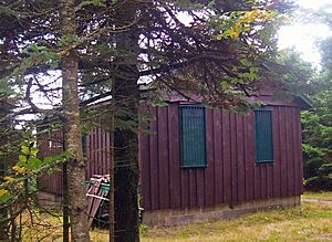
Next to the tower is the observer's cabin. This is a one-story wooden hut with a metal roof. It sits on a concrete base. Just inside the woods is a small wooden outdoor toilet. In the clearing, there is also a wooden picnic table.
A Look Back: The Tower's Story
The Balsam Lake Mountain fire tower was first built by a private club. But it helped everyone by spotting fires. Later, it became public property. Now, it has a new purpose for hikers and history lovers.
Early Days: The Balsam Lake Club (1885–1909)
In the 1800s, many Catskill forests were used for industries like tanning. This industry used tree bark and often left many trees to rot. Loggers also cut down trees for wood and made charcoal. This left the forests in bad shape and increased the risk of large forest fires.
In 1885, the state created the Forest Preserve. This protected forest lands in the Catskills and Adirondacks. The idea was to keep these lands "forever wild." This also meant the state would help protect them from fires.
In 1887, members of the Balsam Lake Club built a tower on the summit. They wanted to spot fires early to protect their hunting and fishing lands. Workers built a small tower from trees cut nearby.
This first tower was destroyed by fire in 1901, likely from a lightning strike. A new 35-foot (11 m) tower was built in 1905. The Balsam Lake Club kept maintaining and staffing it. In 1909, the state's Forest, Fish and Game Commission (FFGC) took over the tower. This agency was a early version of today's DEC.
Public Use and Changes (1909–1970)
After some big fires, the FFGC decided that towers were the best way to find fires. One man in a tower could spot fires better than many people patrolling on the ground. The Balsam Lake tower joined others the state already had on Belleayre and Hunter mountains. It had great views for spotting fires far away.
The state added a special telephone line to the tower. This connected it to Mill Brook Road. This meant observers did not have to hike as far to get to the tower. In its first year, observers spotted fires many miles away.
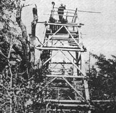
In 1918, the state replaced the old observer's "shanty" with a better cabin. The next year, the open wooden tower was replaced with a 47.5-foot (14.5 m) steel tower. It is believed the current tower was built in 1930.
Mike Todd was the observer from 1918 until 1947. He could sometimes see fires as far away as Northeastern Pennsylvania. He also claimed to have shot over 900 porcupines to stop them from chewing on the cabin!
In the early 1960s, the state built the current observer's cabin. This was the biggest change to the tower area. During this time, observers were very busy. There were many fires due to droughts in 1962 and 1963. The governor even ordered the Forest Preserve to close for short times.
In 1968, an observer named Larry Baker helped find some missing Boy Scouts. They had gotten lost near the tower. Around this time, fire towers started to become less important. People were better educated about fire safety. Local fire departments also improved. Airplanes could cover large areas faster. So, the state slowly began closing and taking down towers.
Decline and Restoration (1971–Present)
By the 1970s, the Balsam Lake tower was mostly kept open for hikers. In 1988, it was officially closed. The lower stairs were removed in 1993 to stop people from climbing it. Hikers still climbed the remaining steps for the views. But the tower was not maintained and started to fall apart.
A DEC forester suggested taking down the tower. He hoped this would make people want to save it. And it worked!
The Catskill Center for Conservation and Development and the DEC helped local communities. They formed the Catskill Fire Tower Restoration Project. Volunteers raised money through concerts and art shows. DEC employees and AmeriCorps volunteers began fixing the tower in 1999. They put in new stairs, a new roof, and new windows for the cab. The tower reopened in 2000.
The Tower Today: A Hiking Destination
The views from the Balsam Lake fire tower are said to be the best in the Catskills. It is a very popular spot for hikers. Some hikers come to join the Catskill Mountain 3500 Club. Others come to complete the Adirondack/Catskill Fire Tower Challenge. Many just come to enjoy the amazing views from the tower.
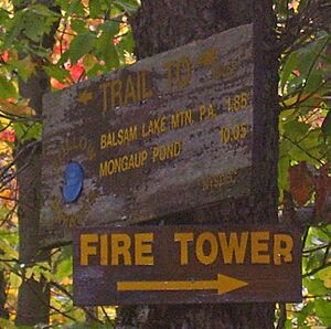
You can reach the tower from three different directions. The two most common ways use the Dry Brook Ridge Trail. This trail has blue markers. It connects to the red-marked Balsam Lake Mountain Trail. This trail makes a short loop over the summit. South of the fire tower, it connects to the yellow-marked Mill Brook Ridge Trail. This trail offers a longer hike from the west.
The northern approach is the most popular. It follows the old jeep road from Mill Brook Road. This is the highest trailhead in the Catskills. It is a longer hike but not as steep as the southern approach. The Mill Brook Ridge Trail was built in 1998. It starts near Alder Lake and runs 6.7 miles (10.8 km) to the Balsam Lake Mountain Trail. This is considered the most challenging route.
From the fire tower, you can see Graham and Doubletop mountains. These are Balsam Lake's taller neighbors to the east. On a clear day, you can even see Slide, the highest Catskill peak. To the north, Dry Brook Ridge looks like a single peak. You might even see Bearpen Mountain, the highest peak outside the Forest Preserve. To the west, you can see lower peaks in Delaware County. To the south, you can see the Beaver Kill Range and other peaks like Peekamoose and Table. On very clear days, you can see the Shawangunk Ridge to the southeast. You might even spot Elk Mountain in Northeastern Pennsylvania far to the southwest.
As part of the restoration project, guides are at the tower on weekends during warmer months. They can tell you more about the tower and its history. Camping is not allowed on the summit, except in winter. If you want to stay overnight, there is a lean-to (a simple shelter) on the south slope of the mountain.
 | May Edward Chinn |
 | Rebecca Cole |
 | Alexa Canady |
 | Dorothy Lavinia Brown |


