
Kingston, New York facts for kids
Quick facts for kids
Kingston, New York
|
|||
|---|---|---|---|
| City of Kingston | |||
|
Stockade District with the Old Dutch Church visible in the background
Firemen's Hall
The Senate House was New York's first Capitol Building where its Constitution was signed
|
|||
|
|||
_highlighted.svg)
Location in Ulster County and the state of New York.
|
|||

Kingston, New York
Location in New York

Kingston, New York
Location in the United States
|
|||
| Country | United States | ||
| State | New York | ||
| County | Ulster | ||
| Settled | 1652 | ||
| Village | April 6, 1805 | ||
| City | May 29, 1872 | ||
| Area | |||
| • City | 8.77 sq mi (22.71 km2) | ||
| • Land | 7.48 sq mi (19.38 km2) | ||
| • Water | 1.29 sq mi (3.33 km2) | ||
| Elevation | 191 ft (58 m) | ||
| Population
(2020)
|
|||
| • City | 24,069 | ||
| • Density | 3,216.92/sq mi (1,242.00/km2) | ||
| • Metro | 177,749 | ||
| Time zone | UTC−5 (Eastern (EST)) | ||
| • Summer (DST) | UTC−4 (EDT) | ||
| ZIP Codes |
12401–12402
|
||
| Area code(s) | 845 | ||
| FIPS code | 36-39727 | ||
| GNIS feature ID | 0979119 | ||


.jpg)


,_New_York_Flag.png)

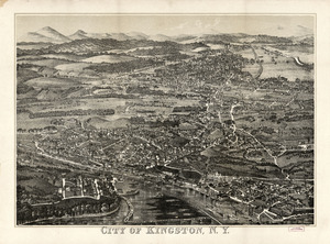
Kingston is a city in Ulster County, New York, United States. It is the main city and the county seat of Ulster County. Kingston is about 91 miles (146 km) north of New York City. It is also 59 miles (95 km) south of Albany, the state capital.
In 2020, about 24,069 people lived in Kingston. The city is part of the larger New York metropolitan area.
Kingston has a very important history. It was New York's first capital city in 1777. During the American Revolutionary War, British soldiers burned the city on October 13, 1777. This happened after the Battles of Saratoga.
In the 1800s, Kingston became a key place for transportation. This was because natural cement was found nearby. The city used railroads and canals to connect with other markets.
Many old buildings in Kingston are part of three special historic areas. These include the Kingston Stockade District uptown, the Midtown Neighborhood Broadway Corridor, and the Rondout-West Strand Historic District downtown. All three are listed on the National Register of Historic Places.
Contents
History of Kingston
_(14776657215).jpg)
Early Settlement and Dutch Influence
Kingston is the traditional home of the Esopus people, a Native American group. As early as 1614, Dutch traders set up a trading post here. It was located at Ponckhockie, where the Rondout Creek meets the Hudson River. They traded European goods for furs with the Lenape and Mohican people.
In 1652, the Esopus people sold some land to the Dutch. The first permanent European settler was Thomas Chambers in 1653. The new settlement was called Esopus, named after the local Native Americans.
More land was bought from the Esopus in 1654. However, the Dutch and Esopus had different ideas about land ownership. This caused problems. For example, Dutch farm animals would sometimes ruin Native American cornfields.
In 1658, Peter Stuyvesant, the leader of New Amsterdam, ordered settlers to move to higher ground. He told them to build a strong fence, called a stockade, around the settlement. This area is now Uptown Kingston. Building this fence led to more conflicts, known as the Esopus Wars.
In 1661, the Dutch officially recognized the settlement as a town. Stuyvesant named it Wiltwijck. In 1663, the Esopus were defeated in the Second Esopus War. The Dutch fought with help from the Wappinger and Mohawk tribes.
British Takeover and the American Revolution
The British took control of New Netherland from the Dutch in 1664. In 1669, the British renamed Wiltwyck to Kingston. This name honored the family of Governor Lovelace.
In 1777, Kingston became the very first capital of New York State. The state's constitution was finished here on April 20. George Clinton was sworn in as the first Governor of New York on July 30, 1777.
During the American Revolutionary War, British troops marched towards Kingston. On October 13, 1777, the city was burned by the British. They came up the Hudson River from New York City. Kingston was an important farming area, providing food for the colonies. The British burned most of the buildings and a lot of wheat.
Before the British arrived, most residents and government officials had already left. They moved to Hurley, New York, for safety. Today, Kingston sometimes re-enacts this historic burning of the city.
Kingston officially became a village on April 6, 1805. In the early 1800s, boats carried people and goods between Kingston and New York City. By 1829, steamboats made the trip even faster.
Growth of Rondout and Wilbur


Rondout was a small farming village. But in 1825, work began on the Delaware and Hudson Canal. This canal connected Rondout to Honesdale, Pennsylvania. When it was finished in 1828, Rondout became a major port for shipping coal.
Natural cement was also found nearby. In 1844, companies started digging for it in Rondout. The Newark Lime and Cement Company shipped cement all over the United States. This business was very successful until cheaper, faster-drying cement was invented.
Workers also cut ice from the Hudson River each winter. They stored it in large warehouses near the river. This ice was used to keep things cold before refrigerators existed. Large brick factories also grew near this busy shipping area.
Rondout's importance as a shipping center changed when railroads arrived. Trains could carry goods faster and directly through Kingston.
Wilbur, also known as Twaalfskill, was another small settlement. It was located upstream from Rondout. Wilbur became a center for shipping bluestone. This stone was used to build sidewalks in New York City.
Kingston officially became a city on May 29, 1872. This happened when the villages of Rondout and Kingston, and the hamlet of Wilbur, joined together.
Geography and Neighborhoods
Kingston has three main neighborhoods:
- The Uptown Stockade Area
- The Midtown Area
- The Downtown Waterfront Area
The Uptown Stockade District was the first capital of New York State. Many stone buildings from the 1600s are still there. The Senate House, built in the 1670s, was used as the state capitol during the revolution.
The Midtown area is the largest neighborhood. It is known for its early 20th-century factories. It is also home to Kingston High School and the historic City Hall building.
The Downtown area was once the village of Rondout. It is now the Rondout-West Strand Historic District. This area is next to the Rondout Creek. The creek flows into the Hudson River. It was the end point of the Delaware and Hudson Canal.
The Rondout neighborhood is famous for its many artists and art galleries. It also hosts several festivals, like the Kingston Jazz Festival.
Kingston is on the west bank of the Hudson River. The city covers about 8.6 square miles (22.3 km²). About 7.3 square miles (18.9 km²) is land, and 1.3 square miles (3.4 km²) is water.
Population and People
As of the 2010 census, Kingston had 23,887 people. Most people (73.2%) were White. About 14.6% were Black or African American. About 13.4% of the population was Hispanic or Latino.
In 2000, about 27% of households had children under 18. The average household had 2.28 people. The average family had 3.02 people.
The median age in the city was 38 years old. This means half the people were younger than 38, and half were older. About 23.9% of the population was under 18.
Arts and Culture in Kingston
Kingston is home to the O+ Festival. This is a unique festival that combines music and art. Artists and musicians trade their talents for health and wellness services.
Sports in Kingston
Kingston Stockade FC is a semi-professional soccer team for men. They play in the National Premier Soccer League. Their home games are at Dietz Stadium.
In 1921, a local team called the Colonels was formed. Major league baseball teams sometimes played against them. Some local players, like Bud Culloton, even went on to play in the major leagues.
Parks and Recreation
Hasbrouck Park was created in Kingston in 1920. It is a large park, covering about 45 acres (18 hectares). The park includes a nature trail for exploring.
Education in Kingston
The Kingston City School District serves the entire city. It has:
- Seven elementary schools
- Two middle schools
- One high school: Kingston High School
Kingston Catholic School is also in the community. It used to have a separate middle school building, but now uses a newer facility.
The Kingston Center of SUNY Ulster (KCSU) is a local college branch. It offers programs, courses, and certifications. It is also where police officers receive basic training.
Transportation in Kingston

You can travel to New York City by bus daily using Trailways of New York. The trip takes about two hours.
Passenger train service to Kingston ended in 1958. However, Amtrak trains still run on the east side of the Hudson River. The Rhinecliff–Kingston Amtrak station is about 11 miles (18 km) away. You can also catch Amtrak and Metro-North commuter trains at the Poughkeepsie station, about 17 miles (27 km) south.
CSX Transportation operates freight trains through Kingston. The Kingston-Rhinecliff Bridge is about 4.32 miles (6.95 km) north. It carries New York State Route 199 across the Hudson River. U.S. Highway 9W runs north and south through the city. The New York State Thruway (Interstate 87) also passes through the western part of the city.
The city has its own bus system, CitiBus. Ulster County Area Transit (UCAT) provides bus service to other parts of Ulster County.
Kingston was historically a very important transportation hub. The Hudson River, Rondout Creek, and Delaware and Hudson Canal were key waterways for trade. At one time, Kingston had four railroad companies and two trolley lines.
Today, the Hudson River Maritime Museum and Trolley Museum of New York are located along the waterfront. They help tell the story of Kingston's transportation history. The Catskill Mountain Railroad also offers scenic train rides from Kingston.
Many projects are underway to connect Kingston's neighborhoods. These projects include new rail trails, bike lanes, and improved streets.
Healthcare Services
Residents in Kingston and nearby areas are served by HealthAlliance of the Hudson Valley. This healthcare system has two hospital campuses:
- HealthAlliance Hospital: Broadway Campus
- HealthAlliance Hospital: Mary's Avenue Campus
HealthAlliance is part of the Westchester Medical Center Health Network. This is a large healthcare system with 10 hospitals in the Hudson Valley.
Images for kids
-
The official flag of Kingston, New York
-
The official seal of Kingston, New York
-
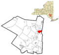
Map showing Kingston's location in Ulster County, New York
Error: no page names specified (help).
See also
 In Spanish: Kingston (Nueva York) para niños
