
New York State Route 199 facts for kids
Quick facts for kids
|
||||
|---|---|---|---|---|
| Lua error in Module:Infobox_road/map at line 15: attempt to index field 'wikibase' (a nil value).
Map of the Mid-Hudson Valley with NY 199 highlighted in red
|
||||
| Route information | ||||
| Maintained by NYSDOT | ||||
| Length | 30.91 mi (49.74 km) | |||
| Existed | 1930–present | |||
| Major junctions | ||||
| West end | ||||
| East end | ||||
| Location | ||||
| Counties: | Ulster, Dutchess | |||
| Highway system | ||||
| Numbered highways in New York Interstate • U.S. • N.Y. (former) • Reference • County
|
||||


New York State Route 199 (NY 199) is an important road in the Hudson Valley area of New York, United States. It stretches for about 30.91 miles (49.75 km). This road connects areas near Kingston to Millerton. Along its way, NY 199 crosses the famous Hudson River using a large bridge. It also goes through towns like Red Hook and Pine Plains. Part of this route used to be part of an older road called the Ulster and Delaware Turnpike. NY 199 got its official name in 1930.
Contents
What is New York State Route 199?
New York State Route 199 is a state highway. This means it is a road managed by the state government. It helps people travel across two counties in New York. These counties are Ulster County and Dutchess County.
Where Does NY 199 Start and End?
NY 199 begins in the west near the town of Ulster. Here, it connects with two other major roads: U.S. Route 9W and U.S. Route 209.
The road then travels east. It ends in the town of North East. At its eastern end, it meets U.S. Route 44 and New York State Route 22.
Important Places Along the Route
As NY 199 goes across the state, it passes through several interesting places.
Crossing the Hudson River
One of the most notable parts of NY 199 is its crossing of the Hudson River. It uses the Kingston–Rhinecliff Bridge to go over the river. This bridge offers great views of the surrounding area.
Towns and Villages
The route also goes through or near several communities.
- It passes through the village of Red Hook. Here, it crosses U.S. Route 9.
- Further east, it goes near the town of Pine Plains. Close to Pine Plains, NY 199 connects with the Taconic State Parkway. This parkway is another important road in New York.
History of NY 199
The road we know as NY 199 has been around for a long time. It was officially named New York State Route 199 in 1930. Before that, some parts of it were used for other purposes.
The Ulster and Delaware Turnpike
A section of NY 199 was once part of the Ulster and Delaware Turnpike. A turnpike was an old type of road where travelers paid a fee to use it. This fee was called a toll. Turnpikes were important for travel and trade in earlier times.
Images for kids
-
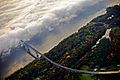
Aerial view of NY 199 as it approaches the Kingston–Rhinecliff Bridge (at left) from the west
-
NY 199 approaching Red Hook
-

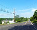
Countryside along NY 199 east of Hammertown


