Red Hook (village), New York facts for kids
Quick facts for kids
Red Hook, New York
|
|
|---|---|
|
Village
|
|
| Incorporated Village of Red Hook | |

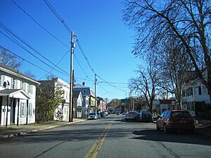
Looking east along Market Street (NY 199)
|
|

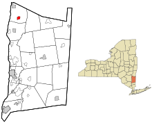
Location of Red Hook, New York
|
|
| Country | |
| State | |
| County | Dutchess |
| Town | Red Hook |
| Incorporation (village) | 1894 |
| Area | |
| • Total | 1.07 sq mi (2.77 km2) |
| • Land | 1.05 sq mi (2.73 km2) |
| • Water | 0.01 sq mi (0.03 km2) |
| Elevation | 220 ft (67 m) |
| Population
(2020)
|
|
| • Total | 1,975 |
| • Density | 1,872.04/sq mi (723.06/km2) |
| Time zone | UTC-5 (Eastern (EST)) |
| • Summer (DST) | UTC-4 (EDT) |
| ZIP codes |
12504, 12507, 12571
|
| Area code(s) | 845 |
| FIPS code | 36-60895 |
| GNIS feature ID | 0962291 |
Red Hook is a small village located in Dutchess County, New York, United States. In 2020, about 1,975 people lived there.
The village is part of a larger area that includes cities like Poughkeepsie and Newburgh. The name "Red Hook" comes from the Dutch words "Roode Hoeck." "Hoeck" means peninsula, and "roode" means red. This name refers to the beautiful red colors of the leaves in the fall.
Red Hook village is found within the larger town of Red Hook. It is located along U.S. Route 9. The village is also close to Bard College and the Hudson River.
Village History
The land where Red Hook is located was once part of a large land grant called the Schuyler Patent. The village used to be known as "Lower Red Hook." Sometimes, people even called it "Hardscrabble."
Some of the first settlers in the area were Nicholas Bonesteel and his wife, Anna Margretha Kuhns. They might have arrived as early as 1723. Part of the village today sits on what was once their farm.
Where is Red Hook?
Red Hook village is quite small. According to the United States Census Bureau, its total area is about 2.9 square kilometers (1.1 square miles). Most of this area is land. Only a tiny part, about 0.03 square kilometers (0.01 square miles), is water.
People of Red Hook
The number of people living in Red Hook has changed over the years. Here's a quick look at the population from different census counts:
| Historical population | |||
|---|---|---|---|
| Census | Pop. | %± | |
| 1870 | 861 | — | |
| 1880 | 936 | 8.7% | |
| 1890 | 935 | −0.1% | |
| 1900 | 857 | −8.3% | |
| 1910 | 960 | 12.0% | |
| 1920 | 827 | −13.9% | |
| 1930 | 996 | 20.4% | |
| 1940 | 1,056 | 6.0% | |
| 1950 | 1,225 | 16.0% | |
| 1960 | 1,719 | 40.3% | |
| 1970 | 1,680 | −2.3% | |
| 1980 | 1,692 | 0.7% | |
| 1990 | 1,794 | 6.0% | |
| 2000 | 1,805 | 0.6% | |
| 2010 | 1,961 | 8.6% | |
| 2020 | 1,975 | 0.7% | |
| U.S. Decennial Census | |||
In the year 2000, there were 1,805 people living in the village. These people lived in 765 households. A household is a group of people living together in one home. About 29.4% of these households had children under 18.
The average household had about 2.36 people. The average family had about 2.92 people. The median age in the village was 39 years old. This means half the people were younger than 39, and half were older.
Getting Around Red Hook
Red Hook has public transportation. It is served by the "C" bus route. This bus route is part of Dutchess County Public Transit.
See also
 In Spanish: Red Hook (villa) para niños
 | John T. Biggers |
 | Thomas Blackshear |
 | Mark Bradford |
 | Beverly Buchanan |

