North East, New York facts for kids
Quick facts for kids
North East, New York
|
||
|---|---|---|
| Town of North East | ||

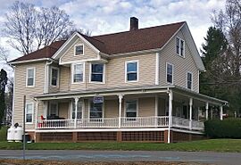
Town hall, in the village of Millerton
|
||
|
||

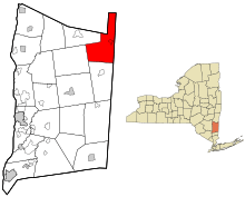
Location of North East, New York
|
||
| Country | United States | |
| State | New York | |
| County | Dutchess | |
| Government | ||
| • Type | Town Council | |
| Area | ||
| • Total | 43.72 sq mi (113.24 km2) | |
| • Land | 43.15 sq mi (111.77 km2) | |
| • Water | 0.57 sq mi (1.47 km2) | |
| Elevation | 1,109 ft (338 m) | |
| Population
(2020)
|
||
| • Total | 2,971 | |
| • Density | 68.85/sq mi (26.58/km2) | |
| Time zone | UTC-5 (EST) | |
| • Summer (DST) | UTC-4 (EDT) | |
| ZIP code |
12546 (Millerton)
|
|
| Area codes | 518, 838 | |
| FIPS code | 36-027-51891 | |
| GNIS feature ID | 0979285 | |
North East is a small town located in Dutchess County, New York. It's in the northeastern part of the county. In 2020, about 2,971 people lived there. A major road, U.S. Route 44, goes right through the town.
Contents
A Look Back: History of North East
The town of North East got its name because it's in the northeastern corner of its county.
Early Settlers and Land
Some of the land in North East came from old land grants called the "Great Nine Partners Patent" (from 1697) and the "Little Nine Partners Patent" (from 1706). The first people to settle here were from Connecticut. They arrived between 1725 and 1730 in a special area known as "The Oblong." This area was not part of the original land grants.
Forming the Town
The Town of Northeast was officially created in 1788. Over time, parts of it were used to form other towns. For example, Milan was created in 1818, and Pine Plains was formed in 1823.
Important Moments
In the early 1800s, a traveling Methodist minister would visit North East often to preach. A company that made slate products started in the town in 1812. During the Revolutionary War, iron ore was mined here. This iron was used to make cannons for the American forces fighting for independence.
Where is North East? Geography
North East covers about 113.2 square kilometers (about 43.7 square miles). Most of this area, about 111.8 square kilometers (43.15 square miles), is land. The rest, about 1.4 square kilometers (0.57 square miles), is water.
Borders and Neighbors
The northern edge of North East touches Columbia County. A small part of its northern border also meets Mount Washington in Massachusetts. To the east, the town shares a border with Connecticut.
Highs and Lows
The highest point in Dutchess County is Brace Mountain, which is 2,311 feet (704 meters) tall. Its summit is located near the Connecticut border in the northeastern part of North East. The lowest point in the town is 530 feet (162 meters) above sea level. This low spot is along Shekomeko Creek, near the border with Pine Plains.
Who Lives Here? Population Facts
| Historical population | |||
|---|---|---|---|
| Census | Pop. | %± | |
| 1820 | 2,037 | — | |
| 1830 | 1,689 | −17.1% | |
| 1840 | 1,385 | −18.0% | |
| 1850 | 1,555 | 12.3% | |
| 1860 | 1,735 | 11.6% | |
| 1870 | 2,179 | 25.6% | |
| 1880 | 2,181 | 0.1% | |
| 1890 | 2,026 | −7.1% | |
| 1900 | 2,047 | 1.0% | |
| 1910 | 2,110 | 3.1% | |
| 1920 | 1,922 | −8.9% | |
| 1930 | 2,119 | 10.2% | |
| 1940 | 2,201 | 3.9% | |
| 1950 | 2,308 | 4.9% | |
| 1960 | 2,489 | 7.8% | |
| 1970 | 2,730 | 9.7% | |
| 1980 | 2,877 | 5.4% | |
| 1990 | 2,918 | 1.4% | |
| 2000 | 3,002 | 2.9% | |
| 2010 | 3,031 | 1.0% | |
| 2020 | 2,971 | −2.0% | |
| U.S. Decennial Census | |||
In 2000, there were 3,002 people living in North East. The town had 1,146 households, and 778 of these were families. The population density was about 69 people per square mile.
Community Makeup
Most people in North East are White (95.6%). There are also smaller groups of African American (2.1%), Asian (0.57%), and Native American (0.1%) residents. About 3.26% of the population identified as Hispanic or Latino.
Many households (54.7%) were married couples living together. About 28.7% of households had children under 18. The average household had 2.5 people.
Age Groups
The average age of people in North East was 40 years old.
- About 23.1% of the population was under 18.
- About 9.2% were between 18 and 24.
- About 26.7% were between 25 and 44.
- About 27.0% were between 45 and 64.
- About 14.0% were 65 or older.
Famous Faces from North East
- Timothy T. Lockwood – He used to be the mayor of Buffalo, New York.
- Heman Lowry – He served as a U.S. Marshal for Vermont.
Exploring North East: Towns and Hamlets
North East is home to several smaller communities and interesting places. Here are some of them:
- Boston Corner – A small community at the northern edge of the town. Parts of it are also in Ancram in Columbia County.
- Coleman Station – A community in the southern part of the town.
- Irondale – A community northwest of the village of Millerton. The oldest mill in North East was built here.
- Millerton – This is a village located on Route 44, close to the Connecticut border.
- Mount Riga – A community in the northern part of the town.
- Northeast – A spot southwest of Northeast Center.
- Northeast Center – A community southwest of Millerton, also on Route 44.
- Oblong – A former community in the town.
- Perry Corners – A location in the southern part of the town.
- Sharon Station – A community on the southern town line.
- Shekomeko – A community in the southwestern part of the town.
- Spencer's Corners – A community named after an early settler, Philip Spencer. It's northeast of Millerton.
- State Line – A community east of Millerton village, right on the New York–Connecticut border.
- Taconic State Park – A large state park located in the northern part of the town.
- Whitehouse Crossing – A community in the northern part of the town.
See also
 In Spanish: North East (Nueva York) para niños
 | Mary Eliza Mahoney |
 | Susie King Taylor |
 | Ida Gray |
 | Eliza Ann Grier |


