
Coleman Station Historic District facts for kids
Quick facts for kids |
|
|
Coleman Station Historic District
|
|

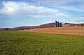
View north towards Taconic Mountains from Sheffield Hill Road, 2008
|
|

Location in New York
|
|
| Location | North East, NY |
|---|---|
| Nearest city | Hudson |
| Area | 1,812 acres (733 ha) |
| Built | 1731–1903 |
| Architectural style | Colonial, Early Republic, various 19th and early 20th century styles |
| NRHP reference No. | 93000945 |
| Added to NRHP | September 30, 1993 |
The Coleman Station Historic District is a special area in the town of North East, New York. It's located near the old New York Central Railroad station called Coleman's. This district is a large rural area with many farms.
It covers almost three square miles (7.33 km2). This makes it the biggest historic district in Dutchess County. A historic district is a place recognized for its important past.
Nine farms were first started here by people from New England in the late 1700s. Over time, these farms changed. They went from raising many different animals to focusing on dairy farming. They used the railroad to sell fresh milk to New York City. By the mid-1900s, one farm here was a huge milk supplier for the city.
Later, people from the city started buying country homes in the area. In the 1990s, some of them worked to make Coleman Station a historic district. This helped protect its old buildings and history. Many buildings here are from the 1700s and 1800s. They show how farming changed over time. Five of these important buildings are listed on the National Register of Historic Places.
Contents
Exploring the Coleman Station Historic District
The Coleman Station Historic District has a unique shape. Its borders follow property lines and roads. The old railroad path, now the Harlem Valley Rail Trail, cuts right through the middle. This trail is popular for walking and biking.

The district is like a big bowl, with Webutuck Creek flowing through it. Hills and flat areas surround this bowl. The lowest point, where the old station was, is about 580 feet (180 m) high. Most of the land is used for farming, with fields and pastures. Some areas are still woodlots (forests).
Because much of the land is open, you can see amazing views in every direction. The Taconic Mountains to the north and east are especially beautiful.
The closest town in New York is Millerton, about four miles (3 km) north. The hamlet of Amenia is three miles (6.4 km) south.
There are 85 buildings, 23 sites, and 9 structures in the district. Most of them are farm-related. Many of these properties help tell the story of the district's past. Four farms and one old estate are so important that they are listed on the National Register of Historic Places by themselves.
A Look Back: History of Coleman Station
The Coleman Station area took a long time for European settlers to arrive. This was because New York and Connecticut argued over who owned the land. The border was finally decided in 1732. Even after that, wars slowed down settlement.
In the early 1800s, farming really started to grow. It changed from general farming to focusing on milk production. This happened after the railroad came through. Farming continued even when railroads became less popular later on. People who moved here later saw the area's historical value. They fought to protect it. Since then, farming in the district has started to grow different types of crops and animals again.
Early Days: Settling the Land (1731–1771)
It's believed that Native Americans had already cleared and farmed this area before Europeans arrived. European settlement was delayed because of land arguments between New York and Connecticut. Few settlers built homes here until the 1730s. That's when the two colonies agreed on the border.
Even after the land was divided and sold, not many people settled here in the mid-1700s. Native Americans had villages in the area, which is how Indian Lake got its name. They were still present in the 1750s.
Most of the Harlem Valley was hard to farm because there wasn't much good land. But the Coleman Station area was different. Settlers from New England found its rich soil perfect for farming. The Wheeler and Collins families were among the first to settle here in the 1760s.
The oldest buildings still standing are the farmhouse and barn at the Wheeler-Collins Farm. They date back to about 1771. By the early 1800s, four large farms existed, all connected to the Wheeler family.
Farming Changes: From Animals to Dairy (1771–1870)
As New England farmers settled, their farming methods changed. In their home states, they mostly grew wheat. In Dutchess County, they started raising a mix of livestock (animals) and cash crops for local markets. Their farms had buildings for different animals. They also made extra money by getting materials like iron and limestone from nearby areas.
The 1850 census (a count of people and what they produce) shows what farms in the district were making. Farms, about 150–200 acres (61–81 ha) each, had 5-6 cows for milking. They also had twice as many cows for meat. They produced hundreds of pounds of butter and cheese. Sheep were common, about a hundred per farm, giving wool each year. Pigs, oxen, and horses were also part of the farm. Most of the land was used for animal pastures. Crops were mainly for animal feed, hay, and potatoes.
Ten years later, the 1860 census showed a big change. There were more cows and fewer pigs and sheep. The number of milking cows increased to 10-20. This change happened because the New York and Harlem Railroad came to the area in 1852. With the railroad, farmers could now send their milk to the growing New York City market. This made dairy farming much more profitable.
The 1870 census first recorded how much fluid milk was produced. Coleman Station farmers' cows produced 10,000–15,000 US gallons (38–57 m3) annually. Farms still made their own butter. But cheese production, which needed a lot of milk, was left to the processing plants. This was the start of a big shift. Farms went from raising many types of animals to almost only dairy farming, which is still common today. Barns got bigger for more cattle, and more land was used for pasture and feed crops.
Railroad and Tourism: A New Era (1850–1923)
When the railroad arrived, a local businessman named Amasa Coleman pushed for a station to be built. This station was named after him. It helped serve both vacationers going to Sharon and the local farmers. The station led to a small business area growing around it, though most of it is gone today.

The railroad also led to an old farmhouse, now called Mutton Hill, becoming a country house. This was the first one in the district. In 1903, Thomas Hidden, a rich industrialist from New York City, bought land to create his large Hiddenhurst estate. He built a big stable for horses, but it's no longer there. His main house, built in a fancy style, is considered the most unique building in the district.

After Hidden died, his estate was bought by the Sheffield Milk Company. They created a large corporate farm. They built a big dairy complex and housing for workers. Another farm, the Wheeler Farm, was renovated to attract summer visitors. They even made a brochure to promote it through the railroad. This marked a change for the district. It went from a close-knit farming community to one where farming was purely a business.
Protecting History: Preservation and Legal Battles (1923–2000)
Changes kept happening. In the 1950s, Sheffield, a major milk supplier, was bought by the Sealtest company. In the 1970s, the railroad stopped passenger service. Freight service continued for another ten years, then the tracks were removed. In 1985, the Ezra Clark House was the first property in Coleman Station to be listed on the National Register.
Around that time, people who owned weekend homes and other residents started working to create a historic district. They formed a group called Friends of Coleman Station. They also worried about a large organic farm, McEnroe Farms, and its composting activities. They feared it could harm the environment and cause bad smells. The farm owners worried that being a historic district would bring rules that would limit their farming.
In 1993, the district was listed on the New York State Register of Historic Places. Two months later, it was listed on the National Register of Historic Places. McEnroe Farms went to court to try and stop the listing. They argued it wasn't important enough and that the state process had problems.
The farm also convinced a federal judge to cancel the federal listing. However, a higher court later reversed this decision. The appeals court said that the National Park Service could list properties independently. They also said that the listing only affects federal agencies, not the farm's daily operations.
New Life: Revitalization in the 21st Century
After the district was created, Sealtest became part of a Canadian company. In 1999, something new came to the district: a coffee roasting facility. The owners of a New York City coffee shop opened it in an old carriage house. They said they chose the area because of its preserved historic feel. This company, Irving Farm Coffee Company, has grown a lot.
Also, a mother-daughter team brought sheep farming back to the district at Dashing Star Farm.
In the 2000s, the old railroad path became useful again. The Harlem Valley Rail Trail was created. It runs through the district. The former Coleman's station site is now used for parking for people who use the trail.
The Friends of Coleman Station group is still active. They work to protect and promote the district. They have a small office with research materials. They also take care of the Coleman Station Burying Ground and a memorial garden. Every year, they organize a cleanup of the district and sometimes offer tours.
Important Places in Coleman Station
Five properties in the district are so important that they are listed on the National Register of Historic Places on their own. Other places are also very significant to the district's history.
National Register Properties
- Oliver Barrett House, Regan and Sheffield Hill roads. This house was likely built in 1853. It was updated in 1915 with a late Victorian style.
- Ezra Clark House, Mill Road. This is the only brick farmhouse in the district. It shows building styles from New England.
- Dakin-Coleman Farm, Coleman Station Road. This early 1800s farmhouse was once divided for two generations of a family.
- Hiddenhurst, Sheffield Hill Road. Thomas Hidden, a retired businessman, built this fancy house. It's known as the most architecturally unique building here.
- Thomas N. Wheeler Farm, Indian Lake and Taylor roads. This is another original 1800s farmhouse. It was later changed to look more like a village house because it was close to the station.
Other Important Places
- Coleman Station Burying Ground, also Oblong Rural Cemetery, Coleman Station Road. Many early residents of the area are buried here. The oldest gravestone dates back to 1749.
- Coleman Station site. Southeast corner of Coleman Station Road and Harlem Valley Rail Trail. This spot is now used for parking for people using the rail trail.
- Mutton Hill, Sharon Station Road. In 1865, this old farmhouse became the first country house in what would become the historic district.
- Old Indian Lake Road, along east side of rail trail between Coleman Station Road and present junction of Indian Lake and Taylor roads. This is the remaining path of the original road before the railroad was built.
- Wheeler-Collins Farm, Coleman Station Road. Among the ten important parts of this farm is an English barn from 1771. It is the oldest building in the district.
Images for kids
-
View north towards Taconic Mountains from Sheffield Hill Road, 2008
