
Ancram, New York facts for kids
Quick facts for kids
Ancram, New York
|
|
|---|---|

The historic Simons General Store (built 1873–4) in the center of Ancram
|
|

Location of Ancram, New York
|
|
| Country | United States |
| State | New York |
| County | Columbia |
| Town of Gallatin | 1803 |
| Government | |
| • Type | Town Council |
| Area | |
| • Total | 42.73 sq mi (110.68 km2) |
| • Land | 42.48 sq mi (110.01 km2) |
| • Water | 0.26 sq mi (0.67 km2) |
| Elevation | 505 ft (154 m) |
| Population
(2020)
|
|
| • Total | 1,440 |
| • Density | 33.70/sq mi (13.01/km2) |
| Time zone | UTC-5 (Eastern (EST)) |
| • Summer (DST) | UTC-4 (EDT) |
| ZIP code |
12502
|
| Area code(s) | 518 |
| FIPS code | 36-021-02099 |
| GNIS feature ID | 0978679 |

Ancram is a small town located in Columbia County, New York. In 2020, about 1,440 people lived here. The town was named after a place called Ancram (now Ancrum) in Scotland. Ancram is found in the southeastern part of Columbia County.
Contents
History of Ancram
Early Days and Iron Works
Before Europeans arrived, Native American groups like the Mahican and Wappinger lived in this area for thousands of years. When European settlers came, the land became part of a large grant given to the Livingston family. This area, near the Roeliff Jansen Kill river, was first known as "Livingston Forge." This was because an iron foundry (a factory for making metal) was built there.
Throughout the 1700s, the Livingston forge made many metal items for the community. Sometimes, the town was called "Scotchtown." This was because many people from Scotland moved there in the late 1700s.
Ancram's Role in the American Revolution
As the Revolutionary War began, the factory in Ancram became very important. It produced things like cannonballs and shot. Most importantly, it made a huge iron chain. This chain was placed across the Hudson River at West Point. It was meant to stop British ships from sailing up the river.
The "Fort Montgomery Chain" was made in 1776 at the Ancram foundry. It was put across the Hudson River between Fort Montgomery and Fort Clinton. On October 6, 1777, British forces attacked these forts. They chose to go around the forts on land instead of trying to break the strong chain. It is believed the British took the chain when they left the fort weeks later. No one knows where it is now.
Changing Names and Borders
After the Revolutionary War, Ancram was officially created in 1803. It was formed from a part of the town of Livingston. At first, it was called "Gallatin." In 1814, its name was changed to "Ancram." This new name honored the Scottish town where the Livingston family came from. Later, in 1830, a part of Ancram was used to create a new town of Gallatin.
Mining for iron and lead was very important for Ancram's economy in the early days. The area now known as Ancramdale was originally called "Ancram Lead Mines."
A small community called Boston Corner used to be part of Massachusetts. But it was easier to reach from Ancram. So, on April 13, 1857, it became part of Ancram, New York. This happened because of an agreement between the two states.
Geography of Ancram
Ancram covers a total area of about 110.7 square kilometers (42.7 square miles). Most of this area, about 110.0 square kilometers (42.5 square miles), is land. The rest, about 0.7 square kilometers (0.26 square miles), is water.
Most of the town's water flows into the Roeliff Jansen Kill river. This river then flows west into the Hudson River. A small part of the town in the southeast drains into Webatuck Creek. This creek flows south to the Ten Mile River. It then goes to the Housatonic River in Connecticut.
The eastern border of Ancram touches both Massachusetts and Dutchess County. The southern border also touches Dutchess County.
Population of Ancram
| Historical population | |||
|---|---|---|---|
| Census | Pop. | %± | |
| 1820 | 3,147 | — | |
| 1830 | 1,533 | −51.3% | |
| 1840 | 1,770 | 15.5% | |
| 1850 | 1,569 | −11.4% | |
| 1860 | 1,720 | 9.6% | |
| 1870 | 1,793 | 4.2% | |
| 1880 | 1,602 | −10.7% | |
| 1890 | 1,332 | −16.9% | |
| 1900 | 1,238 | −7.1% | |
| 1910 | 1,137 | −8.2% | |
| 1920 | 1,015 | −10.7% | |
| 1930 | 850 | −16.3% | |
| 1940 | 1,005 | 18.2% | |
| 1950 | 925 | −8.0% | |
| 1960 | 1,080 | 16.8% | |
| 1970 | 1,215 | 12.5% | |
| 1980 | 1,332 | 9.6% | |
| 1990 | 1,510 | 13.4% | |
| 2000 | 1,513 | 0.2% | |
| 2010 | 1,573 | 4.0% | |
| 2020 | 1,440 | −8.5% | |
| U.S. Decennial Census 2020 | |||
In 2000, there were 1,513 people living in Ancram. There were 595 households, and 430 families. The population density was about 35.5 people per square mile. About 97.69% of the people were White.
About 30.4% of households had children under 18. The average household had 2.54 people. The average family had 2.91 people. The median age in the town was 42 years old.
Communities and Other Locations
.jpg)
- Ancram — This is the main hamlet (a small community) of Ancram. It is in the western part of the town. You can find it on New York State Route 82.
- Ancramdale — This is another hamlet located southeast of the main Ancram hamlet.
- Boston Corner — This hamlet used to be part of Massachusetts. It is right next to the Massachusetts border.
- Taconic State Park — A part of this state park is in the northeastern area of the town.
- Weed Mines — This is a specific location near the northern border of the town.
Images for kids
-
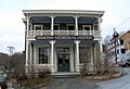
The historic Simons General Store in Ancram.
-
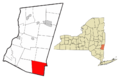
Map showing Ancram's location in Columbia County.
See also
 In Spanish: Ancram (Nueva York) para niños
