Gallatin, New York facts for kids
Quick facts for kids
Gallatin, New York
|
|
|---|---|

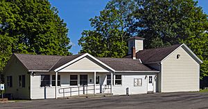
Town hall
|
|

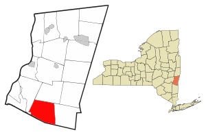
Location of Gallatin, New York
|
|
| Country | United States |
| State | New York |
| County | Columbia |
| Government | |
| • Type | Town Council |
| Area | |
| • Total | 39.63 sq mi (102.65 km2) |
| • Land | 39.11 sq mi (101.30 km2) |
| • Water | 0.52 sq mi (1.35 km2) |
| Elevation | 1,063 ft (324 m) |
| Population
(2020)
|
|
| • Total | 1,628 |
| • Density | 41.080/sq mi (15.860/km2) |
| Time zone | UTC-5 (Eastern (EST)) |
| • Summer (DST) | UTC-4 (EDT) |
| FIPS code | 36-021-28068 |
| GNIS feature ID | 0978984 |
Gallatin is a small town in Columbia County, New York, United States. In 2020, about 1,628 people lived there. This was a slight decrease from 1,668 people in 2010.
Gallatin is located on the southern edge of Columbia County. It is about 100 miles (161 km) north of New York City.
Contents
History of Gallatin
The area where Gallatin is located was once part of Livingston Manor. The town of Gallatin was officially created in 1830. It was formed from a section of the nearby town of Ancram.
The town gets its name from Albert Gallatin, an important figure in American history. Gallatin was one of the largest early settlements in the Roe Jan region. In the 19th century, it had a railroad station and a hotel. It also had stores, a grist mill, and two blacksmith shops. There was a post office and about a dozen houses.
Geography and Landscape
Gallatin covers a total area of about 39.6 square miles (102.6 square kilometers). Most of this area is land, about 39.1 square miles (101.3 square kilometers). The rest, about 0.5 square miles (1.3 square kilometers), is water.
Most of the town's water flows into the Roeliff Jansen Kill. This is a stream that eventually joins the Hudson River. A small part of the town's northeast corner drains into Suydam Creek. This creek then flows into Taghkanic Creek and then to the Hudson River.
The southern border of Gallatin is also the border of Dutchess County. The Taconic State Parkway, a major road, also passes through the town.
Population and People
The population of Gallatin has changed over the years. Here is a look at how many people have lived in the town during different census years:
| Historical population | |||
|---|---|---|---|
| Census | Pop. | %± | |
| 1830 | 1,588 | — | |
| 1840 | 1,644 | 3.5% | |
| 1850 | 1,586 | −3.5% | |
| 1860 | 1,533 | −3.3% | |
| 1870 | 1,416 | −7.6% | |
| 1880 | 1,252 | −11.6% | |
| 1890 | 1,016 | −18.8% | |
| 1900 | 823 | −19.0% | |
| 1910 | 720 | −12.5% | |
| 1920 | 633 | −12.1% | |
| 1930 | 511 | −19.3% | |
| 1940 | 554 | 8.4% | |
| 1950 | 613 | 10.6% | |
| 1960 | 621 | 1.3% | |
| 1970 | 737 | 18.7% | |
| 1980 | 1,292 | 75.3% | |
| 1990 | 1,658 | 28.3% | |
| 2000 | 1,499 | −9.6% | |
| 2010 | 1,668 | 11.3% | |
| 2020 | 1,628 | −2.4% | |
| U.S. Decennial Census 2020 | |||
In 2000, there were 1,499 people living in Gallatin. There were 609 households, which are groups of people living together. Many households were families. The average household had about 2.45 people.
The people in Gallatin were of different ages. About 23.1% of the population was under 18 years old. About 15.4% of the population was 65 years old or older. The average age in the town was 42 years.
Communities in Gallatin
Gallatin is made up of several smaller communities and areas. These include:
- Elizaville – A small community located at the western edge of the town.
- Gallatinville – A community found in the eastern part of the town, along County Road 7.
- Jacksons Corners – An area located near the southern border of the town, close to the Taconic Parkway.
- Lake Taghkanic State Park – A state park that surrounds Lake Taghkanic. It is located near the northern border of the town.
- Mount Ross – A community located at the town line, along the Roeliff Jansen Kill.
- Silvernails – A small community situated south of Gallatinville.
- Snyderville – A community in the northwestern part of the town. Two historic buildings, the William and Victoria Pulver House and the Snyderville Schoolhouse, are listed on the National Register of Historic Places here.
- Spaulding Furnace – A community located southwest of Gallatinville.
See also
 In Spanish: Gallatin (Nueva York) para niños
 | DeHart Hubbard |
 | Wilma Rudolph |
 | Jesse Owens |
 | Jackie Joyner-Kersee |
 | Major Taylor |

