Mount Washington, Massachusetts facts for kids
Quick facts for kids
Mount Washington, Massachusetts
|
|||
|---|---|---|---|

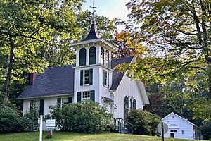
The town church and town hall
|
|||
|
|||
| Nickname(s):
The Town Among the Clouds
|
|||

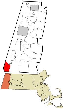
Location in Berkshire County and Massachusetts.
|
|||
| Country | United States | ||
| State | Massachusetts | ||
| County | Berkshire | ||
| Settled | 1692 | ||
| Incorporated | 1779 | ||
| Government | |||
| • Type | Open town meeting | ||
| Area | |||
| • Total | 22.4 sq mi (57.9 km2) | ||
| • Land | 22.2 sq mi (57.5 km2) | ||
| • Water | 0.2 sq mi (0.4 km2) | ||
| Elevation | 1,631 ft (497 m) | ||
| Population
(2020)
|
|||
| • Total | 160 | ||
| • Density | 7.16/sq mi (2.76/km2) | ||
| Time zone | UTC-5 (Eastern) | ||
| • Summer (DST) | UTC-4 (Eastern) | ||
| ZIP code |
01258
|
||
| Area code(s) | 413 | ||
| FIPS code | 25-43300 | ||
| GNIS feature ID | 0618271 | ||
Mount Washington is a small town in Berkshire County, Massachusetts, in the United States. It is located right in the southwestern corner of Massachusetts. The town borders New York and Connecticut.
In 2020, only 160 people lived in Mount Washington. This makes it one of the smallest towns in Massachusetts! The town is named after George Washington, who was a famous leader during the American Revolutionary War.
Contents
History of Mount Washington
Mount Washington was first settled by European people in 1692. It officially became a town in 1779.
Geography and Nature
Mount Washington covers about 57.9 square kilometers (22.4 square miles). Most of this area is land, with a small amount of water. It is the westernmost and southwesternmost town in Massachusetts.
The town is surrounded by other states and towns. To the west, it borders Columbia County, New York. Part of its southern border touches Dutchess County, New York and Litchfield County, Connecticut. Other towns nearby include Egremont to the north and Sheffield to the east.
Mountains and Parks
Mount Washington is located on a high flat area in the Taconic Mountains. Mount Everett is the highest point in the town. It rises about 2,602 feet (793 meters) high. Other mountains like Alander Mountain and Mount Frissell are also nearby. The top of Mount Frissell is in Mount Washington, but its southern side is in Connecticut.
A large part of the town is covered by nature. You can find Mount Washington State Forest and Mount Everett State Reservation here. The town is also home to Bash Bish Falls State Park, which has beautiful waterfalls. The famous Appalachian Trail passes through Mount Washington, coming from Bear Mountain in Connecticut.
Getting Around Mount Washington
Mount Washington is quite remote. There are only four roads that lead out of the town. Only one, East Street, connects to the rest of Massachusetts through Egremont. There are no major state roads inside the town itself. The nearest highway, Interstate 90, is several miles north. For travel, the closest train, bus, and small plane services are in Great Barrington. The nearest big airport is Bradley International Airport in Connecticut.
Population and People
| Historical population | ||
|---|---|---|
| Year | Pop. | ±% |
| 1850 | 351 | — |
| 1860 | 321 | −8.5% |
| 1870 | 256 | −20.2% |
| 1880 | 205 | −19.9% |
| 1890 | 418 | +103.9% |
| 1900 | 122 | −70.8% |
| 1910 | 110 | −9.8% |
| 1920 | 73 | −33.6% |
| 1930 | 60 | −17.8% |
| 1940 | 57 | −5.0% |
| 1950 | 34 | −40.4% |
| 1960 | 34 | +0.0% |
| 1970 | 52 | +52.9% |
| 1980 | 93 | +78.8% |
| 1990 | 135 | +45.2% |
| 2000 | 130 | −3.7% |
| 2010 | 167 | +28.5% |
| 2020 | 160 | −4.2% |
| 2022* | 157 | −1.9% |
| * = population estimate. Source: United States Census records and Population Estimates Program data. |
||
In 2000, there were 130 people living in Mount Washington. It was the smallest town in Berkshire County. It was also the third smallest town in all of Massachusetts. The town had about 5.8 people per square mile, making it very spread out.
Most households were made up of individuals or married couples. The average age of people living in Mount Washington was 52 years old.
Education for Kids
Mount Washington has its own school district, but it does not operate a school. Children from Mount Washington go to school in the Mount Everett Regional School District. This district includes students from nearby towns like Alford, Egremont, and Sheffield.
Younger students (kindergarten and first grade) attend the Appalachian School. Students in grades two through six go to Undermountain Elementary School in Sheffield. For grades 7–12, students attend Mount Everett Regional High School in Sheffield. There are also private schools in nearby towns.
For higher education, the closest community college is in Great Barrington. The nearest state college is Westfield State University.
Fun Community Events
Mount Washington has a special tradition that has been going on for over 85 years: its annual Church Fair. Every year, on the first Saturday in August, people from the town come together. They work as a community to raise money for charity.
See also
 In Spanish: Mount Washington (Massachusetts) para niños
 | James Van Der Zee |
 | Alma Thomas |
 | Ellis Wilson |
 | Margaret Taylor-Burroughs |


