Mount Everett facts for kids
Quick facts for kids Mount Everett |
|
|---|---|

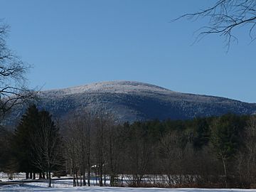
View from Bears Den Road, Sheffield, MA
|
|
| Highest point | |
| Elevation | 2,608 ft (795 m) |
| Prominence | 1,663 ft (507 m) |
| Parent peak | 42° 06' 07"N, 73° 25' 57"W |
| Geography | |
| Location | Southwest Berkshire County, Massachusetts |
| Parent range | Taconic Mountains |
| Geology | |
| Age of rock | Ordovician |
| Mountain type | Thrust fault; metamorphic rock |
| Climbing | |
| Easiest route | Mount Everett Road and Appalachian Trail |
Mount Everett is a tall mountain located in the southwestern part of Massachusetts. It stands at 2,608 feet (about 793 meters) high. This makes it the highest peak in the southern part of the Taconic Mountains, which stretch across Massachusetts, Connecticut, and New York.
The mountain is famous for its amazing views of the southern Taconic Mountains and the nearby Berkshires. It is also known for its special forests of old pitch pine and scrub oak trees. Mount Everett is home to rare plants and animals. The famous Appalachian Trail also crosses its slopes and goes near its top.
The mountain is named after Edward Everett, who was a governor of Massachusetts in the 1800s. A geologist named Edward Hitchcock suggested the name in 1841. Before that, the mountain was sometimes called Bald Mountain or Ball Mountain. Some old maps also show it as "The Dome."
Contents
Exploring Mount Everett
Mount Everett offers many interesting features for visitors to explore. It is a great place to experience nature and see unique landscapes.
Natural Wonders Around Mount Everett
Near Mount Everett, you can find several beautiful natural spots. These include a highland lake and a series of waterfalls.
Guilder Pond and Race Brook Falls
Guilder Pond is a lake high up in the mountains. It sits in a bowl-shaped valley between Mount Everett and Undine Mountain to the north. South of Mount Everett, you'll find Race Brook Falls. This is a popular series of waterfalls that tumble down from a shared rocky ledge between Mount Everett and Mount Race. The water drops about 600 feet (183 meters) over 1200 feet (366 meters) of the brook.
Getting to the Summit
There is a road that goes almost to the top of Mount Everett. However, the upper part of this road has been closed to cars for many years. Hikers can still use it to get closer to the summit.
Where is Mount Everett Located?
Mount Everett is split between two towns in Massachusetts. This means different parts of the mountain are in different places.
Towns and Protected Areas
The very top of Mount Everett and its western side are in the town of Mount Washington, Massachusetts. The eastern slopes of the mountain are in Sheffield, Massachusetts. A large part of the mountain is protected within the Mount Everett State Reservation. Other parts are in the Mount Washington State Forest or are protected by special conservation agreements.
Water Flowing from the Mountain
Water from Mount Everett flows in different directions, eventually reaching the ocean.
East and West Side Drainage
Water from the eastern side of Mount Everett flows into Race Brook. From there, it goes into Schenob Brook, then Hubbard Brook, and finally into the Housatonic River. The Housatonic River eventually empties into Long Island Sound.
Water from the western side of the mountain flows into Guilder Brook and City Brook. These brooks lead to Bash Bish Brook, then the Roeliff Jansen Kill, and finally the Hudson River. The Hudson River flows into New York Bay, which is part of the Atlantic Ocean.
 | Janet Taylor Pickett |
 | Synthia Saint James |
 | Howardena Pindell |
 | Faith Ringgold |

