Egremont, Massachusetts facts for kids
Quick facts for kids
Egremont, Massachusetts
|
||
|---|---|---|

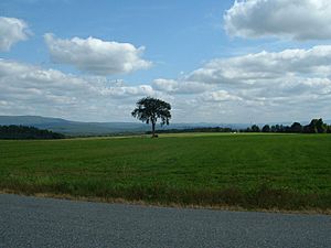
The fields of Egremont Plain, looking northeastward towards the southern Berkshires
|
||
|
||

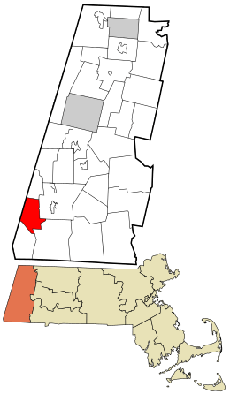
Location in Berkshire County and the state of Massachusetts.
|
||
| Country | United States | |
| State | Massachusetts | |
| County | Berkshire | |
| Settled | 1722 | |
| Incorporated | 1775 | |
| Government | ||
| • Type | Open town meeting | |
| Area | ||
| • Total | 18.9 sq mi (49.0 km2) | |
| • Land | 18.7 sq mi (48.4 km2) | |
| • Water | 0.2 sq mi (0.6 km2) | |
| Elevation | 748 ft (228 m) | |
| Population
(2020)
|
||
| • Total | 1,372 | |
| • Density | 72.52/sq mi (28.00/km2) | |
| Time zone | UTC−5 (Eastern) | |
| • Summer (DST) | UTC−4 (Eastern) | |
| ZIP Codes |
01230 and 01258
|
|
| Area code(s) | 413 | |
| FIPS code | 25-21360 | |
| GNIS feature ID | 0618265 | |
Egremont is a small town in Berkshire County, Massachusetts, United States. It is part of the Pittsfield area. In 2020, about 1,372 people lived here. Egremont has two main parts: North Egremont and South Egremont. Most of the land around them is made up of forests and farms.
Contents
History of Egremont
Early Settlement
Egremont was first settled in 1722 by Dutch families from New York. A few years later, English settlers arrived. The town officially became a town in 1761. It's not fully clear if the town was named after a town in England or after the first Earl of Egremont. For most of its history, Egremont was a farming town. There was also a small area for milling in South Egremont.
Revolutionary War Connection
Around New Year's Day, 1776, General Henry Knox traveled through Egremont. He was moving cannons from Fort Ticonderoga to help the American army in the Siege of Boston. This journey is now known as the Knox Trail. You can find a historical marker about it in North Egremont.
Geography of Egremont
Egremont is located on the western side of Berkshire County in Massachusetts. To its west is Columbia County, New York. The town covers about 49 square kilometers (18.9 square miles). Most of this area is land, with a small amount of water.
Nearby Towns and Cities
Egremont shares borders with several towns:
- Alford to the north
- Great Barrington to the east
- Sheffield to the southeast
- Mount Washington to the southwest
- Copake and Hillsdale, New York in New York to the west
Egremont is about 37 kilometers (23 miles) south of Pittsfield. It is also about 225 kilometers (140 miles) west of Boston.
Mountains and Rivers
Egremont is in a valley, with the Taconic Range mountains to its west.
- Mount Whitbeck and Mount Fray are two mountains nearby.
- Mount Fray is home to the Catamount Ski Area. This ski area is special because it's in two states: Massachusetts and New York!
- Mount Whitbeck and the Jug End form the Jug End State Reservation. This is a place for wildlife and nature.
- The Appalachian Trail, a famous hiking path, goes through this reservation.
- The town is also located along the Green River, which flows into the Housatonic River.
Roads and Transportation
Several roads pass through Egremont:
- Massachusetts Route 23 and Route 41 meet in South Egremont. Route 23 continues into New York.
- Massachusetts Route 71 also goes through the town. This route is part of the historic Knox Trail.
- The closest major highway, Interstate 90 (the Massachusetts Turnpike), is north of town.
- There are no train, bus, or air services directly in Egremont. The closest options are in nearby Great Barrington or Albany International Airport in Albany, New York.
Population of Egremont
| Historical population | ||
|---|---|---|
| Year | Pop. | ±% |
| 1850 | 1,013 | — |
| 1860 | 1,079 | +6.5% |
| 1870 | 931 | −13.7% |
| 1880 | 875 | −6.0% |
| 1890 | 845 | −3.4% |
| 1900 | 758 | −10.3% |
| 1910 | 605 | −20.2% |
| 1920 | 441 | −27.1% |
| 1930 | 513 | +16.3% |
| 1940 | 468 | −8.8% |
| 1950 | 731 | +56.2% |
| 1960 | 895 | +22.4% |
| 1970 | 1,138 | +27.2% |
| 1980 | 1,311 | +15.2% |
| 1990 | 1,229 | −6.3% |
| 2000 | 1,345 | +9.4% |
| 2010 | 1,225 | −8.9% |
| 2020 | 1,372 | +12.0% |
| 2022* | 1,374 | +0.1% |
| * = population estimate. Source: United States Census records and Population Estimates Program data. |
||
In 2020, Egremont had a population of 1,372 people. This makes it one of the smaller towns in Berkshire County. The population density is about 28 people per square kilometer (71 people per square mile).
The average age of people in Egremont in 2000 was 47 years old. About 18% of the population was under 18 years old. About 20% of the population was 65 years or older.
Education in Egremont
Egremont is part of the Southern Berkshire Regional School District. This district serves five towns, including Egremont.
Elementary Education
- Younger students (kindergarten and first grade) from Egremont can attend the South Egremont School. This is a unique one-room schoolhouse.
- Students from pre-kindergarten to fifth grade can also attend the Undermountain Elementary School in Sheffield.
Middle and High School Education
- Students in sixth through twelfth grades attend Mount Everett Regional School.
Higher Education
- For college, the closest community college is Berkshire Community College in Great Barrington.
- The nearest state university is Westfield State University.
- A private college, Bard College at Simon's Rock, is also nearby in Great Barrington.
See also
 In Spanish: Egremont (Massachusetts) para niños
 | Kyle Baker |
 | Joseph Yoakum |
 | Laura Wheeler Waring |
 | Henry Ossawa Tanner |


