Copake, New York facts for kids
Quick facts for kids
Copake, New York
|
|
|---|---|

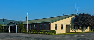
Town hall
|
|

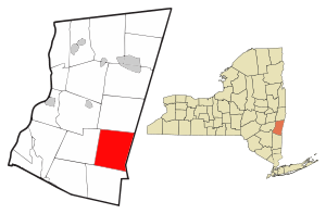
Location of Copake, New York
|
|
| Country | United States |
| State | New York |
| County | Columbia |
| Government | |
| • Type | Town Council |
| Area | |
| • Total | 42.04 sq mi (108.88 km2) |
| • Land | 40.77 sq mi (105.60 km2) |
| • Water | 1.26 sq mi (3.27 km2) |
| Elevation | 568 ft (173 m) |
| Population
(2020)
|
|
| • Total | 3,346 |
| • Density | 82.06/sq mi (31.68/km2) |
| Time zone | UTC-5 (Eastern (EST)) |
| • Summer (DST) | UTC-4 (EDT) |
| ZIP codes |
12516, 12593
|
| Area code(s) | 518 |
| FIPS code | 36-021-18102 |
| GNIS feature ID | 0978865 |
Copake is a small town located in Columbia County, New York, United States. In 2020, about 3,346 people lived there. The town gets its name from a nearby lake. Native Americans called this lake Cook-pake or Ack-kook-peek, which means "Snake Pond".
Copake is found on the eastern side of Columbia County. Part of Taconic State Park is also located along the eastern edge of the town.
Contents
History of Copake
Early Land and Disputes
Copake was once part of a large land grant given in 1686 to Robert Livingston. This land was supposed to be about 400 acres of good land and 2,200 acres of woodland. However, after it was bought from Native Americans, it turned out to be much larger, around 160,000 acres! Livingston then set up a huge estate called Livingston Manor, similar to estates in England. This manor even stretched into what is now Massachusetts.
The first land lease in Copake was given in 1687. But soon, a border dispute started because New England thought its land went all the way to the Hudson River. In 1755, the Massachusetts Bay Colony even created three townships west of the Taconic Mountains. Most of what is now Copake was in one of these townships. Some new settlers were given free land, and some of Livingston's tenants stopped paying rent.
Solving the Border and Land Reform
The border was finally decided in 1757 by officials in London. But farmers in the area still protested. In 1844, a group called the Taconic Mutual Association held a meeting in the center of Copake. When some of their leaders were arrested, even more protests broke out.
This led to the creation of the Anti-Rent Party in New York state. This party pushed for land reform, which meant changing how land was owned and rented. They also wanted a Homestead Act to help develop land in the western parts of the country. This idea became part of the Republican Party's plans and was important in the election of Abraham Lincoln in 1860.
Town Formation and Industries
The town of Copake was officially formed in 1824. It was created by splitting off from another town called Granger, which was then renamed Taghkanic. One of the first big industries in Copake was iron mining and smelting. Today, in Taconic State Park near Copake Falls, you can find the "Ore Pit." This used to be an iron mine and is now a 40-foot deep swimming pond.
Fun Activities in Copake
Copake is a popular spot for summer fun! It has several summer camps for both kids and adults. You can enjoy swimming, hiking, biking, and water skiing. In the winter, people can visit nearby ski mountains like Catamount Ski Area.
Geography of Copake
Copake covers a total area of about 108.9 square kilometers (or 42.04 square miles). Most of this area is land, with about 3.3 square kilometers (or 1.26 square miles) being water. The biggest body of water is Copake Lake, which touches the western border of the town. There are also several other lakes and ponds in the middle and southwestern parts of Copake.
Two important waterways, the Roeliff Jansen Kill and Taghkanic Creek, flow through the town. Both of these eventually lead west to the Hudson River.
Getting to Copake
Copake is easy to reach from New York City. You can drive there using the Taconic State Parkway or NYS Route 22. Because of this, many people who live in busy Manhattan have second homes in Copake. You can also take the Metro-North Railroad to a station about 20 minutes south of the town, which connects to Grand Central Terminal in New York City.
The eastern border of Copake is also the border of Berkshire County, Massachusetts. The town is about sixteen miles from the small Massachusetts town of Great Barrington.
Population Changes in Copake
| Historical population | |||
|---|---|---|---|
| Census | Pop. | %± | |
| 1830 | 1,675 | — | |
| 1840 | 1,505 | −10.1% | |
| 1850 | 1,652 | 9.8% | |
| 1860 | 1,839 | 11.3% | |
| 1870 | 1,847 | 0.4% | |
| 1880 | 1,905 | 3.1% | |
| 1890 | 1,515 | −20.5% | |
| 1900 | 1,277 | −15.7% | |
| 1910 | 1,283 | 0.5% | |
| 1920 | 1,114 | −13.2% | |
| 1930 | 1,165 | 4.6% | |
| 1940 | 1,498 | 28.6% | |
| 1950 | 1,478 | −1.3% | |
| 1960 | 1,630 | 10.3% | |
| 1970 | 2,209 | 35.5% | |
| 1980 | 2,854 | 29.2% | |
| 1990 | 3,118 | 9.3% | |
| 2000 | 3,278 | 5.1% | |
| 2010 | 3,615 | 10.3% | |
| 2020 | 3,346 | −7.4% | |
| U.S. Decennial Census | |||
Over the years, the number of people living in Copake has changed. In 1830, there were 1,675 residents. The population grew steadily through the 19th and 20th centuries, reaching its highest point in 2010 with 3,615 people. By 2020, the population was 3,346.
Communities and Locations in Copake
Here are some of the interesting communities and places you can find in the town of Copake:
- Camphill Village – This is a special community for adults with developmental disabilities.
- Copake (also known as "Copake Flats") – This is the main village area in the southern part of the town.
- Copake Falls – A small community located just north of Copake village.
- Copake Iron Works – This was once a community in the town, and now it's part of Taconic State Park.
- Copake Lake – This is a lake on the western edge of the town. There's also a community that surrounds the lake.
- Craryville (formerly "Bains Corner") – A community in the northwestern part of the town.
- Taconic Shores – A community where property owners live, located northwest of Copake village. It surrounds Robinson Pond.
- Taconic State Park – This large park covers the Taconic Mountains along the eastern side of the town.
- Weedmines – A specific location found at the southern border of the town.
- West Copake (formerly "Andersons Corners") – A community in the southwestern part of the town, southwest of Copake village.
Notable People from Copake
Some well-known people have connections to Copake:
- Henry Astor – He had a home in West Copake.
- Mariah Carey – The famous singer had a home in Craryville. Her 1993 music video for the song "Dreamlover" was also filmed in the town and nearby areas.
- Nancy Fuller – She is a chef and host of the TV show Farmhouse Rules on the Food Network. She and her husband, David, have a dairy farm here.
- Katharine Lente Stevenson (1853–1919) – She was a reformer, missionary, and editor known for her work in the temperance movement.
See also
 In Spanish: Copake (Nueva York) para niños
 | Georgia Louise Harris Brown |
 | Julian Abele |
 | Norma Merrick Sklarek |
 | William Sidney Pittman |


