Hurley (CDP), New York facts for kids
Quick facts for kids
Hurley, New York
|
|
|---|---|

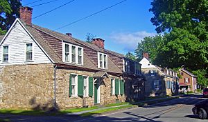
The historic stone houses of Hurley
|
|

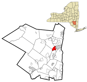
Location in Ulster County and the state of New York.
|
|
| Country | United States |
| State | New York |
| County | Ulster |
| Area | |
| • Total | 5.52 sq mi (14.30 km2) |
| • Land | 5.49 sq mi (14.21 km2) |
| • Water | 0.03 sq mi (0.08 km2) |
| Elevation | 197 ft (60 m) |
| Population
(2020)
|
|
| • Total | 3,346 |
| • Density | 609.80/sq mi (235.45/km2) |
| Time zone | UTC-5 (EST) |
| • Summer (DST) | UTC-4 (EDT) |
| ZIP code |
12443
|
| Area code(s) | 845 |
| FIPS code | 36-37132 |
| GNIS feature ID | 0953520 |
Hurley is a small community in Ulster County, New York, United States. It's known as a "hamlet," which is a small village or settlement. In 2020, about 3,346 people lived there.
Hurley is located near the eastern edge of the larger Town of Hurley. A big part of the hamlet is called the Hurley Historic District. This area is very special because it has many old buildings. It is even recognized as a National Historic Landmark, meaning it's an important historical site for the whole country.
Contents
History of Hurley
Early Settlement Days
The first people to live near Hurley were the Esopus Indians. They were a group of Native Americans from the Delaware tribe. In the spring of 1662, settlers from the Netherlands and France moved to the area. They came from a nearby town called Wiltwyck. The new settlement was named Nieu Dorp, which means "new village" in Dutch.
However, the Esopus Indians were not happy with how the Dutch treated them. In June 1663, they attacked Hurley and Kingston. This event is known as the Second Esopus War. The village of Hurley, which had eight houses, was destroyed. Several women and children were taken away. It took a whole year for all the captured people to return to their families. Even though the village was quickly rebuilt, some French settlers moved away. They went on to start a new town called New Paltz.
In September 1664, the English took control of the Dutch colony called New Netherland. In 1669, Governor Richard Lovelace gave English names to some of the Dutch towns. Nieu Dorp became Horley, which is pronounced Hurley. This name came from Lovelace's family home in Horley, England. He also moved the English soldiers to Marbletown. This helped to calm down the tensions in the area. Still, Hurley kept its Dutch language, customs, and building styles. It was located along the Old Mine Road, which connected Dutch settlements in the Upper Delaware Valley to Kingston.
Hurley During the American Revolution
During the American Revolutionary War, the British tried to divide the colonies. Their plan was to take control of the Hudson River Valley. British Generals John Burgoyne and Henry Clinton led this effort. Burgoyne marched south from Canada, while Clinton sailed north.
On October 16, 1777, a British force led by General John Vaughan burned the village of Kingston. At that time, Kingston was the capital of New York. Many people from Kingston escaped to Hurley. After Kingston was burned, an old stone house in Hurley, the Van Deusen House, briefly became the state capital.
British troops were called back before they reached Hurley. The local militia, led by Colonel Johannes Snyder, helped save the grain crops. They fired artillery for four hours, which slowed down the British advance. As the British ships moved up the river, General George Clinton set up his troops in Marbletown. He then moved his command to the Houghtaling House in Hurley. This allowed him to keep a closer eye on the British. Hurley was a good spot for a military base. It had roads leading to Kingston, the Rondout Creek, and other towns like Saugerties and Katsbaan.
On October 10, 1777, a British officer named Lieutenant Daniel Taylor was captured. He was carrying a secret message from General Henry Clinton to General John Burgoyne. Taylor was a loyalist, meaning he supported the British. He traveled in civilian clothes to deliver messages. Usually, such messengers were not considered spies who would be sentenced to death. However, an American spy named Nathan Hale had been hanged by the British a year earlier. So, Lieutenant Taylor was put on trial in New Windsor. Many of the officers judging him were from Connecticut. He was found guilty and sentenced to be hanged.
American troops were trying to reach Kingston to defend it from the British. They left New Windsor and took Taylor with them. They arrived in Hurley on October 17. Taylor was held in the Dumond House. On the morning of October 18, Lieutenant Taylor was taken to a sweet apple tree on Schoolhouse Lane. There, he was hanged.
After leaving Kingston, the British ships sailed upriver to Saugerties. A raiding party crossed the river and burned some estates. When the British learned that General Burgoyne had surrendered at Saratoga, they sailed south. On October 24, they rejoined other British forces. Once the British threat was gone, General Clinton left Hurley. He moved his troops back to their original base.
After the American Civil War, until the early 1900s, the biggest business in Hurley was quarrying bluestone. In 1871, Hurley had a church, two hotels, a store, a school, and several other shops. A 160-foot-long wire bridge crossed the creek.
Hurley Historic District Homes
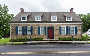
The Hurley Historic District is famous for its old stone houses. These homes were built in the Dutch style of the early Hudson Valley. Many of them are still standing today.
Here are some of the notable houses:
- The Dumond House was built in 1685. During the Revolutionary War, the Continental Army used it as a temporary guardhouse.
- The Patentee Manor was built before the 1700s by the Cole family.
- Part of the Ostrander - Elmendorf House, built in 1709, was a tavern called the Half Moon during the Revolutionary War.
- The Jonathan Crispell House was built in 1725 by a farmer named Jonathan Crispell.
- The Polly Crispell House, built in 1735, once had a blacksmith's shop.
- The Jan Van Deusen Jr. House was built in 1744 by Captain Jan. Its parlor was used as a meeting room for the New York State Committee of Safety during the Revolutionary War.
- The two-story Ten Eyck House was built in 1786 by Dr. Richard Ten Eyck. It was a gift for his wife, Jenett Baker.
Every year, on the second Saturday of July, the Hurley Reformed Church holds an event called Stone House Day. On this day, visitors can often tour some of these historic stone houses.
Geography and Location
Hurley is located at 41°55′14″N 74°3′16″W / 41.92056°N 74.05444°W. A main road, US 209, runs through the middle of the community.
According to the United States Census Bureau, Hurley covers about 5.5 square miles (14.3 square kilometers). Most of this area, about 5.5 square miles (14.2 square kilometers), is land. A very small part, about 0.04 square miles (0.1 square kilometers), is water.
Population and People
| Historical population | |||
|---|---|---|---|
| Census | Pop. | %± | |
| 2000 | 3,561 | — | |
| 2010 | 3,458 | −2.9% | |
| 2020 | 3,346 | −3.2% | |
| U.S. Decennial Census | |||
In the year 2000, there were 3,561 people living in Hurley. There were 1,415 households, and 1,049 families. The population density was about 647 people per square mile.
About 31.2% of the households had children under 18 living with them. Most households (62.3%) were married couples living together. About 22.0% of all households were made up of people living alone.
The average age of people in Hurley in 2000 was 43 years old. About 23.1% of the population was under 18. About 18.3% were 65 years old or older.
The median income for a household in Hurley was $58,624. This means half of the households earned more than this amount, and half earned less. For families, the median income was $64,261.
See also
 In Spanish: Hurley (condado de Ulster) para niños
 | Shirley Ann Jackson |
 | Garett Morgan |
 | J. Ernest Wilkins Jr. |
 | Elijah McCoy |


