
Saugerties, New York facts for kids
Quick facts for kids
Saugerties, New York
|
|
|---|---|

Saugerties from the Hudson
|
|
_highlighted.svg)
Location in Ulster County and the state of New York.
|
|

U.S. census map of town
|
|

Saugerties, New York
Location in the United States
|
|
| Country | United States |
| State | New York |
| County | Ulster |
| Area | |
| • Total | 67.96 sq mi (176.02 km2) |
| • Land | 64.57 sq mi (167.25 km2) |
| • Water | 3.39 sq mi (8.77 km2) |
| Population
(2020)
|
|
| • Total | 19,038 |
| • Density | 280.135/sq mi (108.158/km2) |
| Time zone | UTC-5 (EST) |
| • Summer (DST) | UTC-4 (EDT) |
| ZIP code |
12477
|
| Area code(s) | 845 |
| FIPS code | 36-111-65299 |

Saugerties (pronounced SAW-ger-teez) is a town in the northeastern part of Ulster County, New York. In 2020, about 19,038 people lived here. The village of Saugerties is also located within the town.
A part of the town is inside Catskill Park. Major roads like U.S. Route 9W and New York State Route 32 go through Saugerties. These roads are close to the New York State Thruway (Interstate 87), which also passes through the town.
Contents
History of Saugerties
Early Settlements and Mills
In the 1650s, a man named Barent Cornelis Volge ran a sawmill on the Sawyer's Kill creek. He sold lumber to the nearby Rensselaerswick estate. He bought the land from the Esopus Native Americans before 1663. Volge likely left the area when the first Esopus War began in 1658.
In April 1677, Governor Edmund Andros bought land from the Esopus chief Kaelcop. He paid with items like cloth, a blanket, bread, and a shirt. The Mynderse House, an old home, was built around 1685 by John Persen, who owned an early mill.
Palatine German Settlers
In October 1710, about 300 families from the Palatine region of Germany came to England. They then settled on both sides of the Hudson River. The camp on the west side became known as West Camp in Saugerties. The British government sent them to make supplies for their navy.
The villages at West Camp were called Elizabethtown, Georgetown, and Newtown. Sawmills were built on the Esopus Creek. In 1998, a monument was put up at St. Paul's Lutheran Church in West Camp to remember their arrival.
Growth and Revolution
Before 1730, Dutch farmers and Palatine settlers moved to the Katsbaan area. In 1732, they built a stone Dutch Reformed Church.
During the American Revolution, British ships stayed in Saugerties from October 18-22, 1777. They burned estates like Clermont and Belvedere across the Hudson River. The British also destroyed boats and homes. While there, British General Vaughan learned that Burgoyne had surrendered at Saratoga. The British fleet left the area on October 22, 1777, and never returned.
The town of Saugerties was officially formed from the town of Kingston on April 5, 1811. At that time, the small community of Saugerties had only 21 houses.
Industrial Development
Henry Barclay, an importer from Manhattan, moved to Saugerties around 1825. He built a dam on the Esopus Creek and started the Ulster Iron Works around 1828. This factory made iron bars and employed about 300 people.
At the same time, Barclay built a paper mill, which started working by 1827. He brought skilled workers from England to run his mills. After Barclay died in 1851, the mill was managed by Norman White and Joseph B. Sheffield. They bought the mill in 1857.
The paper mill was rebuilt several times after fires. By 1877, it produced two and a half tons of paper daily and employed about 130 people. The mills continued to operate until 1969. Another paper mill was built by Martin Cantine in 1888, which made coated papers for magazines. This mill closed in 1975 and burned down in 1978.
The village of Saugerties was first named "Ulster" in 1831. It changed its name to "Saugerties" in 1855.
Quarrying and Other Industries
In 1832, blue stone quarrying began in nearby Toodlum (now Veteran). At one point, 2,000 men worked in this industry. They shipped about $1.5 million worth of blue stone each year from Glasco, Malden, and Saugerties. This stone was used for sidewalks, paving, and window sills, especially in New York City.
By 1870, the town of Saugerties had about 4,000 people. The ice industry also grew from the 1880s to the early 1900s. Icehouses were in Glasco and Malden, and ice was harvested from the Esopus and Sawyerkill creeks. The brick-making industry also started in Glasco.
Steamboat Era
In the late 1800s, steamboats were important for travel and trade. In 1879, the steamer Ansonia crashed near the Saugerties Lighthouse. In 1892, two steamboats, the M. Martin and Tremper, collided near the lighthouse while trying to reach the dock first. In 1903, the steamboat Saugerties burned down. Its remains were still visible at very low tides in 2014.
Modern Times and Festivals
In 1908, the Orpheum Theater was built. It showed movies and hosted vaudeville acts and roller skating. Famous performers like Lucille Ball and Burns and Allen appeared there.
In 1930, the famous musician Ernest S. Williams started his School of Music in Pine Grove. Many of his students became successful musicians.
The 1939 film It's a Wonderful World has scenes that are supposed to take place in Saugerties.
The famous music group The Band and Bob Dylan recorded many songs together in 1967. They used the basement of a pink house in West Saugerties. This house became known as "Big Pink". These recordings were later released as The Basement Tapes.
The Hudson Valley Garlic Festival began in 1989. In 1992, the Kiwanis Club of Saugerties took over the festival. It is now held at Cantine Field every September and attracts about 50,000 people.
In 1994, Saugerties hosted the Woodstock '94 music festival. This was held 25 years after the original Woodstock Festival. Saugerties is only about 9 miles (14 km) east of the town of Woodstock.
HITS ("Horseshows In The Sun"), a large horse show facility, opened in Saugerties in 2003. It covers 200 acres (0.81 km2) and has 10 rings.
In 2005, the Esopus Bend Conservancy was formed. This group has bought over 150 acres (0.61 km2) of land along the Esopus Creek to protect it.
In 2014, Saugerties hosted the Hudson Music Project. This festival became known as the "Mudson Project" because heavy rain turned the concert and camp areas into mud.
St. John the Evangelist Church
Catholic workers, many of them quarrymen, used to travel to St. Mary of the Snow Church in the village for Mass. Mr. Russell, who owned the quarries, offered land for a new church. This led to the establishment of St. John the Evangelist Church in Quarryville.
Historic Places to Visit
Saugerties has many interesting historic places.
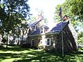
- Dubois-Kierstede Stone House: Built in 1727, this old stone house is now the Kiersted House Museum.
- Loerzel Beer Hall
- Main-Partition Streets Historic District
- Osterhoudt Stone House
- Opus 40: A large outdoor sculpture made of dry stone by artist Harvey Fite.
- Saugerties Lighthouse
- Augusta Savage House and Studio
- Trinity Episcopal Church: This church was built in 1833. It has a beautiful window designed by William Morris.
- Trumpbour Homestead Farm
- Wynkoop House: Built around 1740 by descendants of Dutch settlers.
- Big Pink: The house where The Band and Bob Dylan recorded music.
Saugerties Lighthouse

The original lighthouse was built in 1835. It helped guide ships away from shallow waters and into Esopus Creek. It used five whale-oil lamps for light. This lighthouse burned down in 1848. It was rebuilt by 1850, using mineral-oil lamps instead.
In 1867, the government approved $25,000 to build a new lighthouse. This new lighthouse was finished in 1869. In 1873, a cast-iron lantern room was added. It had a walkway for cleaning the glass panels.
In 1888, the Saugerties harbor was made deeper. A small path was built from the lighthouse to the mainland. In 1909, a fog bell was added. In the late 1940s, the lighthouse got telephone, electricity, and steam heat.
In 1954, the light was automated, meaning it no longer needed a light keeper. The Coast Guard closed the lighthouse. In 1985, the Saugerties Lighthouse Conservancy was formed. This group worked to restore the lighthouse. After a lot of work, it was reopened by the Coast Guard to help guide ships again. The base of the original lighthouse can still be seen as a small island next to the current one.
Geography of Saugerties
The town of Saugerties covers about 68 square miles (176.2 km2). Most of this is land, with about 3.5 square miles (9.0 km2) being water. The northern border of the town is the border with Greene County. The eastern border is the Hudson River, which separates Saugerties from Dutchess and Columbia counties. The Esopus Creek flows into the Hudson River south of Saugerties village.
A study in 2016 found that the Catskill Animal Sanctuary, Opus 40, and HITS are popular places that attract tourists to Saugerties.
Population of Saugerties
| Historical population | |||
|---|---|---|---|
| Census | Pop. | %± | |
| 1820 | 2,699 | — | |
| 1830 | 3,750 | 38.9% | |
| 1840 | 6,216 | 65.8% | |
| 1850 | 8,307 | 33.6% | |
| 1860 | 9,537 | 14.8% | |
| 1870 | 10,455 | 9.6% | |
| 1880 | 10,375 | −0.8% | |
| 1890 | 10,436 | 0.6% | |
| 1900 | 9,754 | −6.5% | |
| 1910 | 9,632 | −1.3% | |
| 1920 | 8,245 | −14.4% | |
| 1930 | 8,752 | 6.1% | |
| 1940 | 8,960 | 2.4% | |
| 1950 | 9,232 | 3.0% | |
| 1960 | 13,608 | 47.4% | |
| 1970 | 16,961 | 24.6% | |
| 1980 | 17,975 | 6.0% | |
| 1990 | 18,467 | 2.7% | |
| 2000 | 18,821 | 1.9% | |
| 2010 | 19,482 | 3.5% | |
| 2020 | 19,038 | −2.3% | |
| U.S. Decennial Census | |||
In 2010, there were 19,482 people living in Saugerties. There were 8,163 households and 5,193 families. Most of the people (94.2%) were White. About 1.7% were Black, and 1.1% were Asian. About 5% of the population was Hispanic or Latino.
About 26.7% of households had children under 18. The average age of people in Saugerties was 42.9 years.
Education in Saugerties
The Saugerties Central School District serves the entire town. This includes Saugerties High School. The Roman Catholic Archdiocese of New York used to run Catholic schools in Ulster County. St. Mary of the Snow School in Saugerties closed in 2013.
Famous People from Saugerties
Many notable people have connections to Saugerties:
- Darnell Edge (born 1997), a basketball player.
- Jimmy Fallon, host of NBC's Tonight Show, grew up in Saugerties.
- Irving Fisher (1867–1947), a famous economist.
- Harvey Fite (1903–1976), a sculptor who created Opus 40.
- Dorothy Frooks (1896–1997), an author.
- Tom Hallion, a Major League Baseball umpire.
- Frank Hannigan (1931–2014), a former director of the United States Golf Association.
- John Henson (1965–2014), a Muppets performer and son of Jim Henson.
- Maurice Hinchey, a United States Congressman.
- K. Leroy Irvis (1919–2006), an African-American politician.
- Linda Montano, a performance artist.
- Glenford Myers, a computer scientist and author.
- Anton Myrer (1922–1996), a United States Marine Corps veteran and author.
- Joe Sinnott, a Marvel Comics artist.
- Roger Donlon, the first Medal of Honor recipient of the Vietnam War.
- The Band, a music group that lived in "Big Pink" while recording with Bob Dylan.
- Augusta Savage (1892–1962), an African-American sculptor.
- Dennis Bermudez, a mixed martial artist.
- Jeremiah Russell (1786–1867), a U.S. representative.
- Robert M. Place, an artist and Tarot scholar.
- Adam Adamowicz (1968–2012), a video game concept artist.
- Gilbert R. Spalding (1812–1880), a showman and circus owner.
- John Thorn, an author and baseball historian.
- Jay Ungar and Molly Mason, American folk musicians.
- Margaret E. Winslow (1836–1936), an activist and author.
Communities and Locations in Saugerties
The town of Saugerties includes several smaller communities and areas:
- Asbury – A small community near the northern town line.
- Barclay Heights – An area in the southern part of the village.
- Blue Mountain – A community in the western part of the town.
- Canoe Hill – A community north of Saugerties village.
- Centerville – A community west of Veteran.
- Eavesport – A community on Route 9W, north of Saugerties village.
- Fish Creek – A community southwest of Saugerties village.
- Flatbush – A community in the southeastern corner of the town.
- Glasco – A community in the southeastern part of the town, by the Hudson River.
- Glenerie – A community in the southeastern part of the town on Route 9W.
- High Woods – A community in the southwestern part of the town.
- Katsbaan – A community northwest of Saugerties village.
- Malden-on-Hudson – A community by the Hudson River, north of Saugerties village.
- Manorville – A community north of West Saugerties.
- Mount Marion – A location in the southeastern part of the town.
- Mount Marion Park – A community west of Glasco.
- Quarryville – A community west of Katsbaan.
- Petersons Corner – A location south of Fish Creek.
- Pine Grove – A location west of Centerville.
- Saxton – A community in the northwestern corner of the town.
- Saugerties – The main village, located in the eastern part of the town.
- Saugerties South – A community south of Saugerties village, also known as Barclay Heights.
- Shultis Corners – A community in the southwestern part of the town.
- Veteran (also called Toodlum) – A community west of Saugerties village.
- West Camp – A community on Route 9W, north of Eavesport.
- West Saugerties – A community near the western town line.
Images for kids
-
The Dubois-Kierstede Stone House (1727)

See also
 In Spanish: Saugerties (Nueva York) para niños
