Rondout Creek facts for kids
Quick facts for kids Rondout Creek |
|
|---|---|
|
|
Rondout/Wallkill watersheds
|
|
| Country | United States |
| State | New York |
| Region | Catskills |
| Counties | Ulster, Sullivan |
| Municipality | Towns of Olive, Denning, Neversink Wawarsing, Marbletown, Rochester, Rosendale, Esopus, Ulster |
| Physical characteristics | |
| Main source | Rocky Mountain Olive 2,980 ft (910 m) 41°58′17″N 74°21′56″W / 41.97139°N 74.36556°W |
| River mouth | Hudson River Kingston 0 ft (0 m) 41°55′12″N 73°57′46″W / 41.92000°N 73.96278°W |
| Basin features | |
| Basin size | 1,100 sq mi (2,800 km2) |
| Tributaries |
|
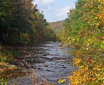
The Rondout Creek is a 63.3-mile-long (101.9 km) river in New York State. It flows through Ulster and Sullivan counties. This creek is a tributary of the Hudson River.
The Rondout Creek starts high up on Rocky Mountain in the eastern Catskills. It flows south into the Rondout Reservoir. This reservoir is an important part of New York City's water supply.
After the reservoir, the creek flows through a valley between the Catskills and the Shawangunk Ridge. It then goes over a famous spot called High Falls. Finally, it reaches the Hudson River at Kingston. Along the way, it meets another river, the Wallkill River.
The name "Rondout Creek" comes from an old fort, or "redoubt," built near its mouth. The Dutch word for redoubt is reduyt. Old records from 1666 show the spelling Ronduyt, which later became "Rondout."
In the 1800s, the Rondout Creek became very important for business. The Delaware and Hudson Canal followed the creek from Napanoch to the village of Rondout. This village, now part of Kingston, grew quickly as a busy port for the canal.
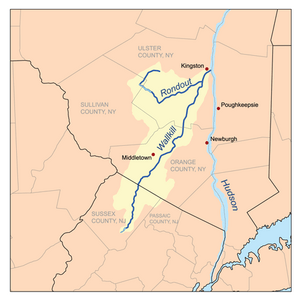
Today, the creek is still important for the reservoir that supplies water. It also offers great chances for fishing and other fun outdoor activities. The creek and its branches drain a huge area, over 1,100 square miles (2,850 km2), reaching all the way to Sussex County, New Jersey.
Contents
How the Rondout Creek Flows
The Rondout Creek changes a lot along its path. This is because of the different landscapes it passes through. Also, human projects like the canal and reservoir have changed how it flows.
From Mountains to Reservoir
The very beginning of the Rondout Creek, called its headwaters, is like a typical mountain stream. It starts below the mountain pass between Rocky Mountain and Balsam Cap. The creek flows south down Rocky Mountain. It gets water from smaller streams like Picket Brook.
In its first two miles, the creek drops 1,440 feet (440 m). It then turns southwest into a wider valley called Peekamoose Gorge. Most of the land around this part of the creek is protected as part of New York's Forest Preserve. This means it is kept wild and undeveloped.
The rocky stream has popular swimming holes. One is called Blue Hole because its deep water looks greenish. Further along, the creek is joined by streams like Buttermilk Falls Brook and High Falls Brook. Many of these streams start in the Slide Mountain Wilderness Area.
The area around the creek is popular for trout fishing. This is because the water is very clear and clean. The creek passes the small town of Sundown and gets a bit wider.
The Reservoir and Beyond
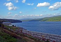
After flowing under NY 55A, the creek widens into the Rondout Reservoir. This large body of water is about 9-mile (14 km) long. Routes 55 and 55A run along the reservoir.
The creek leaves the Catskill Park at an elevation of 840 feet (260 m). It flows east through a rocky, wider streambed. It follows Route 55 closely, sometimes turning north to Honk Lake.
The Rondout Creek then reaches Napanoch. Here, it flows under US 209 and meets the Ver Nooy Kill. It then turns northeast, flowing next to the Shawangunk Ridge.
Through the Rondout Valley
As the creek continues northeast, it becomes wider and deeper. It forms the bed of a widening valley. Near Eastern Correctional Facility, you can see the first remains of the old canal.
The creek flows towards Kerhonkson, where Route 55 and US 44 cross it. US 209 continues to run next to the Rondout towards High Falls. Here, the creek curves east around the northern end of the ridge.
At High Falls, the creek goes over a beautiful waterfall. This waterfall gives the community its name. It is just below NY 213.
Lower Rondout and Kingston
Around the north end of the Shawangunks, the Rondout Creek gets water from many streams. These include Peters Kill, Stony Kill, and Coxing Kill. The creek then curves more to the east.
Route 213 now runs alongside the Rondout. The empty ditch of the old canal is also visible. The creek flows to Rosendale. This town grew because of the canal and a local cement industry.
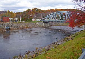
In Rosendale, the creek flows under Route 213 and NY 32 in a special channel. It then returns to a more natural path and flows under the New York State Thruway. East of the Thruway, the Wallkill River joins the Rondout from the south.
The Rondout then turns north, then east again, crossing Route 213 once more. At Creeklocks, you can still see the last lock of the old canal.
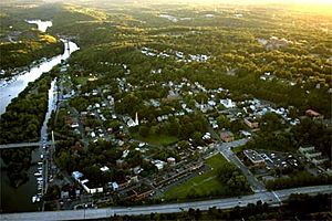
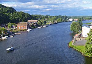
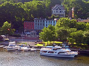
In Kingston, the creek gets wider. It flows under two bridges: the historic Kingston–Port Ewen Suspension Bridge and the newer John T. Loughran Bridge. The waterfront area in Kingston is now a lively place with many boats. Old shipbuilders' factories line the northern bank. One of them is now the Hudson River Maritime Museum.
After a slight curve through some marshy areas, the Rondout Creek flows into the Hudson River. This happens near the Rondout Lighthouse, right across from Rhinecliff.
History of the Rondout Creek
The Rondout Creek has played an important part in the history of New York.
Early Settlements
The first Dutch settlers saw how valuable the creek was. They used it as a port for their settlement along the nearby Esopus Creek. In 1653, a settler named Christoffel Davits built a house here. A fort was built by the government in 1660. Local Native Americans also used this area often.
The Canal Era
The Rondout Creek became very important for business after the American independence. In the early 1820s, two businessmen from Philadelphia had an idea. They wanted to transport high-quality anthracite coal from Northeastern Pennsylvania to New York City.
Since railroads were not common yet, they decided to build a canal. This canal would run from Honesdale, Pennsylvania, to the Hudson River at the village of Rondout. In 1828, their company got permission to build it. The Delaware and Hudson Canal opened a few years later.
Coal was moved from canal barges to river ships at Rondout. Because of this, Rondout quickly became a very busy town. The canal was successful until the late 1800s, when trains became cheaper for transport. The canal stopped operating in 1904. The area where the canal ended is now Kingston's Rondout-West Strand Historic District. This area is listed on the National Register of Historic Places.
The Reservoir Era
In the mid-1900s, the creek found another important use. A famous naturalist named John Burroughs had explored the upper parts of the creek. He wrote about how pure and clean the water was. He said it was good for both people and fish. He called it "the ideal brook."
New York City had been building reservoirs in the Catskills since 1915. In 1937, the city started building Merriman Dam near Lackawack. This area was flooded to create the Rondout Reservoir. This allowed New York City to use the pure waters Burroughs had written about.
Water from the reservoir began reaching city homes in 1951. The reservoir itself was finished three years later. Today, the Rondout Reservoir is a major part of the New York City water supply system. It supplies about half of the city's daily water. It also connects to other reservoirs like Neversink, Pepacton, and Cannonsville through the Delaware Aqueduct.
 | Kyle Baker |
 | Joseph Yoakum |
 | Laura Wheeler Waring |
 | Henry Ossawa Tanner |


