
Rosendale, New York facts for kids
Quick facts for kids
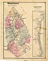
Rosendale, New York
|
|
|---|---|
_highlighted.svg)
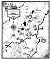
Location in Ulster County and the state of New York.
|
|
| Country | United States |
| State | New York |
| County | Ulster |
| Area | |
| • Total | 20.75 sq mi (53.73 km2) |
| • Land | 19.98 sq mi (51.74 km2) |
| • Water | 0.77 sq mi (1.99 km2) |
| Elevation | 56 ft (17 m) |
| Population
(2020)
|
|
| • Total | 5,782 |
| • Estimate
(2016)
|
5,903 |
| • Density | 278.65/sq mi (107.612/km2) |
| Time zone | UTC-5 (Eastern (EST)) |
| • Summer (DST) | UTC-4 (EDT) |
| ZIP code |
12472
|
| Area code(s) | 845 |
| FIPS code | 36-63737 |
| GNIS feature ID | 0979435 |
Rosendale is a town located in the middle of Ulster County, New York, in the United States. It used to have a village also called Rosendale, mainly around Main Street. However, this village was officially closed down in 1977 after a public vote. In 2020, about 5,782 people lived here.
Contents
History of Rosendale
-
Rosendale in 1875
-
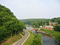
Joppenbergh Mountain (left), Route 213 (center) and the Rondout Creek (right), viewed from the Rosendale trestle overlooking the town
-
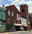
The Rosendale Theatre, a single-screen movie theater on Main Street
-
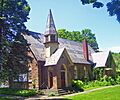
The Rosendale Library, in the now-unincorporated Rosendale Village
-
Rosendale in 1938


When Europeans first settled in this area, the Lenapes lived here. They were a group of Algonquian peoples. The land that became Rosendale was likely founded by Jacob Rutsen in 1680. He bought 600 acres from the Lenapes, which stretched across the Rondout Creek.
Rutsen first leased the land. Later, he bought more and built a home where he lived from 1700 until he passed away in 1730. The Town of Rosendale was officially created in 1844. It was formed from parts of the towns of Hurley, Marbletown, and New Paltz.
In 1872, Hamilton Child from Syracuse, New York published a book. It was called "Gazetteer and Business Directory of Ulster County, N. Y." This book described the town of Rosendale.
St. Peter's Roman Catholic Church
In the mid-1800s, priests from St. Peter's in Poughkeepsie also served churches in Saugerties and Rondout. In 1840, Father John N. Smith, who was the pastor in Poughkeepsie, began to care for the people in Rosendale. In 1842, the next pastor, Father Myles Maxwell, held a Mass in a cooper shop. That same year, Maxwell became the first full-time pastor of St. Mary's in Rondout. Rosendale then became a mission church served from Rondout.
St. Peter's Roman Catholic Church was officially started by Father Thomas Martin O.P. He was the pastor of St. Mary's in Rondout. Church services were first held in Walter Delmar's home. In August 1850, the very first Mass was celebrated in the new church building. St. Peter's remained a mission of St. Mary's until 1855. Then, Father Edward Lynch, who was an assistant at St. Mary's, became the pastor of the new St. Peter's parish in Rosendale.
In 1874, Father Martin O'Flaherty became the pastor. More and more Catholic people were moving to Rosendale because of jobs in the cement quarries and the Delaware & Hudson Canal. Because of this, a new, bigger church building was needed. Arthur Crooks designed the new church. The first Mass in this new church was held on Christmas Day in 1876.
In 1881, pastor John J. Gleason built a school and a convent for the parish. The Sisters of Charity taught at the school. When Gleason passed away in 1894, he left $500 to Kingston hospital in his will. A mission church was also started in Whiteport. In 1897, Father P. Maughan, who was a Civil War veteran, became pastor. He built the parish hall.
Rosendale Cement: A Strong History

The Rosendale area is most famous for making a special type of building material called natural cement. The Rosendale natural cement industry started in 1825. This was during the time the Delaware and Hudson Canal was being built. The canal was finished in 1828, and this amazing cement was used in its construction.
Rosendale natural cement quickly became known for its high quality. Engineers trusted it, and it was used to build many important landmarks in the United States. These include the famous Brooklyn Bridge, the base of the Statue of Liberty, Federal Hall National Memorial, and one of the wings of the United States Capitol. However, the industry started to decline in the early 1900s.
Rosendale natural cement was made from a rock called dolomite. This dolomite was dug out of mines in the Rosendale and Whiteport areas. The natural amounts of magnesium and clay in the dolomite from this region were perfect for making cement. It didn't need any of the extra chemicals that modern Portland cement uses.
Several old dolomite mines still exist in the Rosendale area. One mine is on the Snyder Estate property. It is part of a museum that teaches about the history of the Rosendale natural cement industry. This museum is run by the Century House Historical Society, and the mine is open for people to visit. Other mines have been used for different things, like growing mushrooms or as filming locations for movies. A company called Iron Mountain uses at least one mine to store records, from tiny microfiche to data backup tapes.
In 2004, some cement mining started again in Rosendale. Rosendale natural cement is now being produced once more. Freedom Cement LLC, located in North Brookfield, Massachusetts, makes this natural cement. It is used for projects that restore historic buildings.
Geography of Rosendale

The United States Census Bureau states that the town covers a total area of about 20.8 square miles (53.7 square kilometers). Of this, 19.9 square miles (51.7 square kilometers) is land. The remaining 0.8 square miles (1.9 square kilometers), or 3.90%, is water.
Rosendale has natural and man-made features that either cut through it or form its borders. The New York State Thruway (Interstate 87) runs through the town. The Rondout Creek flows into the Wallkill River near the eastern border of the town.
Population and People
| Historical population | |||
|---|---|---|---|
| Census | Pop. | %± | |
| 1850 | 2,418 | — | |
| 1860 | 2,826 | 16.9% | |
| 1870 | 3,625 | 28.3% | |
| 1880 | 4,724 | 30.3% | |
| 1890 | 6,063 | 28.3% | |
| 1900 | 6,278 | 3.5% | |
| 1910 | 3,717 | −40.8% | |
| 1920 | 1,959 | −47.3% | |
| 1930 | 2,192 | 11.9% | |
| 1940 | 2,548 | 16.2% | |
| 1950 | 2,950 | 15.8% | |
| 1960 | 4,228 | 43.3% | |
| 1970 | 5,422 | 28.2% | |
| 1980 | 5,933 | 9.4% | |
| 1990 | 6,220 | 4.8% | |
| 2000 | 6,352 | 2.1% | |
| 2010 | 6,075 | −4.4% | |
| 2020 | 5,782 | −4.8% | |
| U.S. Decennial Census | |||
Based on the census from 2000, there were 6,352 people living in the town. These people made up 2,587 households, and 1,634 of these were families. The town had about 318.5 people per square mile (123.0 people per square kilometer). There were 2,857 housing units, with an average of 143.3 units per square mile (55.3 units per square kilometer).
Most of the people in the town were White (95.72%). Other groups included African American (1.79%), Native American (0.28%), and Asian (0.44%). About 0.43% were from other races, and 1.34% were from two or more races. People who identified as Hispanic or Latino made up 2.63% of the population.
Out of the 2,587 households, 30.4% had children under 18 living with them. About 48.3% were married couples living together. In 10.1% of households, a female was the head of the house with no husband present. Also, 36.8% were not families. About 28.2% of all households were made up of single individuals. And 8.4% had someone living alone who was 65 years old or older. The average household had 2.45 people, and the average family had 3.02 people.
The population in the town was spread out by age. About 24.6% were under 18 years old. About 6.8% were between 18 and 24. The largest group, 31.9%, was between 25 and 44. About 25.3% were between 45 and 64. And 11.3% were 65 years old or older. The average age was 38 years. For every 100 females, there were about 97.3 males. For every 100 females aged 18 and over, there were about 93.5 males.
The average income for a household in the town was $44,282. For a family, the average income was $51,444. Males earned an average of $34,321, while females earned $28,787. The average income per person in the town was $21,303. About 8.4% of families and 11.9% of the total population lived below the poverty line. This included 17.5% of those under 18 and 9.6% of those aged 65 or older.
Communities and Locations in Rosendale
Communities
- Binnewater – A small community located north of the main Rosendale village area.
- Bloomington – A community in the northeast part of the town, southeast of Whiteport.
- Bruceville – A community in the southwest part of the town, southwest of Rosendale village.
- Cottekill – A community located northwest of Rosendale village.
- Creeklocks – A community at the eastern edge of the town. It is south of Bloomington and on the west side of Rondout Creek.
- Hickory Bush – A community in the northeast part of the town. It is south of Whiteport and on the west side of Rondout Creek.
- High Falls – A community and a census-designated place (meaning it's a specific area counted by the census) at the town line in the southwest.
- High Falls Park - A community mainly found around Mossy Brook Road.
- Kallops Corners – A community located north of Rosendale village.
- Lawrenceville – A community west of Rosendale village, along Route 213.
- Lefevere Falls – A community next to the Thruway, northeast of Rosendale village.
- Maple Hill – A community north of Lefever Falls and Rosendale village.
- Rosendale (also known as Rosendale Village or Rosendale Hamlet) – A community and census-designated place in the eastern half of the town, near Rondout Creek. It used to be an official village until 1977.
- Tillson – A community and census-designated place south of Rosendale village.
- Whiteport – A community in the very northeast corner of the town, right next to the Thruway.
Locations
- Sturgeon Pool – A wide section of the Wallkill River. It is located at the eastern town line on NY route 213.
See also
 In Spanish: Rosendale (Nueva York) para niños
