
Joppenbergh Mountain facts for kids
Quick facts for kids Joppenbergh Mountain |
|
|---|---|

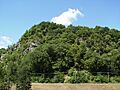
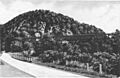
Joppenbergh Mountain, viewed from across the Rondout Creek
|
|
| Highest point | |
| Elevation | Nearly 500 feet (150 m) |
| Listing | List of mountains of New York |
| Geography | |

Joppenbergh Mountain
Location in New York

Joppenbergh Mountain
Location in the United States
|
|
| Location | Rosendale Village, New York, U.S. |
| Topo map | Rosendale Quadrangle |
| Geology | |
| Age of rock | Paleozoic |
Joppenbergh Mountain is a mountain about 500-foot (152 m) tall. It is located in Rosendale Village, a small community in Ulster County, New York. The mountain is made of a type of rock called carbonate bedrock, covered by material left behind by glaciers.
Joppenbergh Mountain was named after Jacob Rutsen, who founded the area. For many years in the late 1800s, people mined the mountain for dolomite. This rock was used to make natural cement. A big cave-in happened on December 19, 1899, which destroyed mining equipment and tunnels inside the mountain. Luckily, all the miners were outside eating lunch when it happened, so no one was hurt. Since then, the mountain has had small shakes and rocks falling from time to time.
In the late 1930s and early 1940s, Joppenbergh Mountain became a popular spot for ski jumping competitions. Even some Olympic skiers came to compete! Skiing started again in the 1960s with a new slope, and competitions continued until 1971. More recently, in 2011, a group called the Open Space Institute bought the mountain to protect it and allow people to enjoy it.
Contents
What's in a Name?

Joppenbergh Mountain is named after Colonel Jacob Rutsen. His original name was Jacobsen Rutger van Schoonderwoerdt. Jacob Rutsen was a merchant and the son of a Dutch immigrant. He started the first settlement in what is now the town of Rosendale, New York, in the late 1600s.
The spelling of the mountain's name has been written in different ways, like Joppenberg and Joppenburgh. It has also been called Jacob's Nose and Jacob's Mount. In an old document from the early 1700s, it was even called Jobsenbright.
Mountain Makeup

People have measured Joppenbergh Mountain's height as either 485 feet (148 m) or 495 feet (151 m). Both of these measurements show that Joppenbergh is not the tallest point in Rosendale. The highest point in the town is a 600-foot (180 m) peak in the Shawangunk Ridge.
The main rock layer under the mountain is made of limestone and dolomite. These rocks were formed during the Paleozoic era, a very long time ago. Most of these types of rocks in Rosendale are found north of the Rondout Creek. Because of these rocks, the area has a special kind of landscape called karst topography. This means you can find "sink holes, disappearing streams, caves, and springs" there.
The surface of the mountain is covered with loose material left by glaciers. This includes outwash and till. In some places, you can see the mountain's bedrock sticking out. The soil on parts of the mountain is very thin, less than 20 inches (51 cm) deep. This makes it hard for water to soak into the ground. Other parts of the mountain are very steep, with a 30 percent slope. About 75 percent of the 117-acre (47 ha) property is too steep to build on easily.
Mountain History
Mining and Collapses

In 1825, engineers working on the Delaware and Hudson Canal discovered large amounts of dolomite rock in the area. This rock was perfect for making natural cement. Joppenbergh Mountain had a lot of this mineral, so it was heavily mined. Several quarries, like the New York and Rosendale Cement Company, operated on the mountain. No single company owned the whole mountain.
By late December 1899, so much mining had been done that the mountain became unstable. This led to a series of landslides and a huge cave-in on December 19. Four collapses happened that day, starting at 8 AM. The biggest one was at 11:30 AM, when the Black Smoke Mine tunnels collapsed. At first, people thought fifteen workers had died. But it turned out that all 150 miners were outside eating lunch when the collapse happened.
The collapse blocked the nearby canal and road. It also caused a boiler to explode, which shook the Rosendale trestle nearby. The damage was estimated to cost between $20,000 and $25,000 at that time. Another, even bigger collapse happened the next week, late at night. This one was thought to be caused by the December 19 collapse. After the landslides, many people came to the village to take pictures of the fallen rocks. Some even claimed one photo showed the Madonna. Because rocks kept falling, some people wanted to destroy the mountain in 1907.
Skiing on Joppenbergh
In the 1930s, tourism in Rosendale was booming, bringing in almost $700,000 each year from spring to autumn. The Rosendale Township Association, started in 1934, wanted to find new ways to attract tourists in the winter. In 1936, they asked a Brooklyn-based telemark skiing club to build a new 40-meter (130 ft) ski jumping slope in Rosendale. The club rented Joppenbergh from its owner, Warren Sammons.
Rosendale's first ski jumping competition was on January 24, 1937. The ski track was designed by Harold Schelderup, a ski hill designer from Norway. Bad weather canceled the main events, but a skiing show still took place. That April, the Telemark club held a special dinner. They planned a summer competition by covering the mountain with "straw and pine needles." Harold Schelderup performed in this summer event. The ski track was covered with borax, and the competition was held on July 18, 1937. About 3,300 people watched as "jumpers took off from an in-run covered with borax and landed on a hill covered with mats and carpets topped with straw and borax."

In 1937, Olympic skier Ottar Satre set a record jump of 112 feet (34 m). The next year, a 25-foot (7.6 m) extension was added to the top of the mountain to help jumpers go farther. On January 23, 1938, Norwegian skier Nils Eie won by jumping 128 feet (39 m). Harold Schelderup also competed. More competitions were held in 1940 and 1941. The slope was made longer, to 50 meters (160 ft), in 1941. However, when the United States entered World War II, many skiers joined the military, and competitions stopped after the war.
Skiing started again on Joppenbergh in the 1960s. The Rosendale Nordic Ski Club was formed in 1964. They created the Joppenbergh Mountain Corporation (JMC) to manage the property. They sold shares of stock to raise money to build a new slope and buy the mountain for $20,000. The JMC took control of the property on August 20, 1964. They planned to build a new ski slope where the old one was, and a parking lot for 10,000 cars. Their goal was to make Rosendale the "Nordic Ski Capital of the East."
A new 70-meter (230 ft) slope was finished on November 14, 1965. It even had a snowmaking system for artificial snow. On January 30, 1966, skier Leif Bringslimark made a 152-foot (46 m) jump from the new slope. Competitions were held in 1967 and 1968. The winner in 1968 was Per Coucheron, a 22-year-old student who jumped 206 feet (63 m). The slope was icy before the competition, but a snowmaking machine and club members helped prepare it.
The Rosendale Outing Ski Club held a competition on January 25 and 26, 1969, with 3,000 people watching. Olympic medalist Franz Keller jumped 212 feet (65 m) down a 65-meter (213 ft) slope. He even reached 214 feet (65 m) during practice. It had rained before the competition, making the track "extremely fast," even though 20 truckloads of snow were brought in. Several participants fell, and one went to the hospital.
Another jump took place on January 18, 1970. The Rosendale Outing Ski Club joined the Rosendale Nordic Ski Club that year. The new club organized Rosendale's last skiing competition on February 6 and 7, 1971. Keller's 212-foot (65 m) record was broken twice on February 6 by Hugh Barber, a student. He jumped 213 feet (65 m) and 217 feet (66 m) during the competition, and 226 feet (69 m) during practice, in front of 3,500 people. Even though Barber thought the hill was in "great condition," 10 to 15 percent of skiers fell.
Skiing stopped on Joppenbergh because of bad weather and it wasn't making enough money. Problems with the slope's design and disagreements among club members also played a part. The slope was then left unused. The JMC continued to own and take care of the property even after skiing ended.
Modern Times
Rocks still fall from the mountain face from time to time. In 1984, State Route 213 was moved 50 feet (15 m) away from Joppenbergh and closer to Rondout Creek. This was done to keep drivers safe. A retaining wall was also built at the bottom of the mountain to stop falling rocks from reaching the road.

In 2003, the town of Rosendale thought about renting or buying land near Joppenbergh to expand parking on Main Street. The town later agreed to rent the Joppenbergh property for 10 years, at $3,500 each year. This lease allowed the town to create a park called Willow Kiln Park. This park has several old, unused cement kilns. Willow Kiln Park has been used for art shows and concerts.
By December 2009, the entire mountain was put up for sale for $500,000. In March 2011, the Open Space Institute (OSI) offered to buy the 117-acre (47 ha) property for $185,000 and sell it to the town for $85,000. This deal would allow the town to use the mountain for noncommercial activities and keep the parking lot. Some officials thought this would solve the town's parking problems.
A public meeting about the purchase was held on April 6, 2011, with over 175 people attending. Residents brought up concerns like the town's responsibility for falling rocks and sinkholes. Others worried about road access to the parking lot. Some people wanted to buy the property to build more parking and an amphitheater. Supporters of the purchase said owning Joppenbergh would connect the Wallkill Valley Rail Trail to Main Street and increase nearby property values. The town board voted 3–2 to buy the mountain on April 13.

A petition with 298 signatures asked for a public vote on the purchase. However, the board felt that OSI funds would not be available by the time a vote could be held. Opponents protested the decision with signs near the mountain. The town was not legally required to hold a vote because the money for the purchase was not borrowed. The board planned to use a $340,000 surplus fund from a previous land sale. However, a June 2011 audit found that most of this money had already been used, with only $79,000 left.
Some local businesses thought about helping to pay for the mountain. This extra money would not require a public vote. Business owners worried that parking costs would go up if a different group bought the property. A nonprofit group, the Joppenbergh Mountain Preservation Association, was created in June 2011 to raise money to buy the mountain, parking lot, and Willow Kiln Park.
To lower the price, the town board asked the mountain's owners to reduce the rent for the parking lot by $32,000. The town also considered buying only the parking lot and Willow Kiln Park. However, the owners said the 117-acre (47 ha) property would not be split up. In the end, the OSI bought Joppenbergh without any money from the town. They officially owned the property in October 2011. By this time, most of the JMC's original owners had passed away, and owning the property was no longer profitable for them.
In 2012, the OSI gave ownership of the property to a local conservation group called the Wallkill Valley Land Trust (WVLT). This group started working with local businesses and town departments to create a plan for how the land would be used. Their goal was to connect Joppenbergh's development with the repair of the nearby railroad trestle and the expansion of the rail trail. In late September 2012, the WVLT held a meeting about a plan that would allow deer hunting on the property starting in 2013 and would not allow entry into several caves on the mountain.
Images for kids
-
Joppenbergh Mountain, viewed from across the Rondout Creek
-
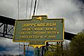
A historic marker placed by the New York State Education Department, describing Joppenbergh as the namesake of Rosendale's founder
-
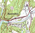
A topographic map of Rosendale, showing Joppenbergh's contour lines (upper left)
-
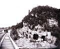
Cement mines on Joppenbergh Mountain before its 1899 collapse
-
A depiction of Joppenbergh and the nearby Rosendale trestle, during the time period in which ski jumping began on the mountain's slopes
-
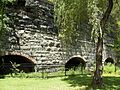
Defunct cement kilns in Willow Kiln Park, at the base of Joppenbergh
-
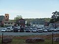
The municipal parking lot behind Main Street, leased by the town of Rosendale since 2004
