Hurley, New York facts for kids
Quick facts for kids
Hurley, New York
|
|
|---|---|
| Town of Hurley | |
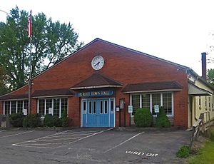
Hurley Town Hall
|
|
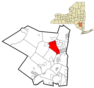
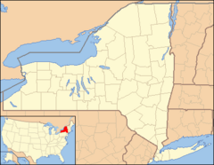
Location in Ulster County and the state of New York.
|
|
| Country | United States |
| State | New York |
| County | Ulster |
| Area | |
| • Total | 35.97 sq mi (93.15 km2) |
| • Land | 29.91 sq mi (77.47 km2) |
| • Water | 6.06 sq mi (15.68 km2) 16.74% |
| Population
(2020)
|
|
| • Total | 6,178 |
| • Density | 204.91/sq mi (79.12/km2) |
| Time zone | UTC-5 (Eastern (EST)) |
| • Summer (DST) | UTC-4 (EDT) |
| FIPS code | 36-111-37143 |
Hurley is a town located in Ulster County, New York. In 2020, about 6,178 people lived there. The town is in the northeastern part of the county. It is west of the city of Kingston. A large part of Hurley is inside the beautiful Catskill Park.
The Town of Hurley includes several smaller communities. These are the hamlets of Hurley, West Hurley, and Glenford. There is also a specific area called Hurley that is a census-designated place.
Contents
History of Hurley
Early Settlement and Name Change
In 1662, Petrus Stuyvesant started a village called Niew Dorp. This village was built where Native Americans had lived before. In 1663, the Esopus attacked and destroyed the village. They took some people captive, but these captives were later set free.
The English took control of the Dutch colony in 1664. In 1669, the village was settled again and renamed Hurley. It was likely named after the Lovelace family, who were important people from Hurley in England.
Growth and Farming Life
In 1708, the town of Hurley grew much larger. New land was added to the north and south. The southern part of Hurley quickly became home to farmers. Villages like Bloomingdale and Wagondale (later called Creeklocks) were formed.
The discovery of limestone in the area was important. Limestone is used to make cement. This made the area economically valuable. The village of Rosendale became a center for this industry. These villages later became part of the town of Rosendale in 1844.
The central part of Hurley, often called "Old Hurley," remained a farming community. Families worked together to grow grain in the Esopus Valley. They supplied food to the growing colony and to the American forces during the American Revolutionary War.
Hurley as a Capital
From October to December 1777, Old Hurley was very important. It served as the military headquarters for General George Clinton's army. It was also the temporary capital of New York State. The capital later moved to Poughkeepsie.
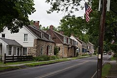
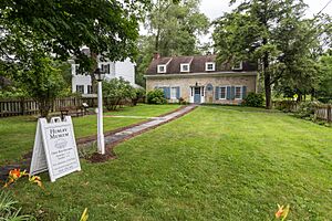
Old Hurley's Main Street is famous for its old stone houses. These houses have been lived in for over 300 years. They are listed on the National Register of Historic Places. Some of these homes are open to visitors once a year on Stone House Day in July. One house even has the Hurley Heritage Society's museum.
Bluestone and the Ashokan Reservoir
The northern part of Hurley was mostly forests. But in the 1830s, a special type of rock called bluestone was found. Bluestone was used for sidewalks, road curbs, and building fronts. Villages like West Hurley, Glenford, and Ashton grew because of the bluestone industry.
In 1917, New York City needed more water. So, land in the valley was used to create the Ashokan Reservoir. The villages of Glenford and West Hurley were flooded. Their residents moved to new locations near the reservoir. However, the village of Ashton was never rebuilt.
Over time, parts of Hurley were used to create other towns. These include New Paltz (1809), Esopus (1818), Olive (1823), Rosendale (1844), and Woodstock (1853). The southern part of Hurley includes a place called Stony Hollow.
Geography of Hurley
Hurley covers about 36 square miles (93.2 square kilometers). About 30 square miles (77.6 square kilometers) is land. The remaining 6 square miles (15.6 square kilometers) is water.
The Esopus Creek, which flows into the Hudson River, runs through the town. The eastern part of the Ashokan Reservoir is in the northern part of Hurley.
Major roads in Hurley include U.S. Route 209, which goes through the eastern part of town. NY 28 crosses the town from east to west.
Population Information
| Historical population | |||
|---|---|---|---|
| Census | Pop. | %± | |
| 1820 | 1,352 | — | |
| 1830 | 1,408 | 4.1% | |
| 1840 | 2,201 | 56.3% | |
| 1850 | 2,003 | −9.0% | |
| 1860 | 2,364 | 18.0% | |
| 1870 | 2,987 | 26.4% | |
| 1880 | 2,521 | −15.6% | |
| 1890 | 2,135 | −15.3% | |
| 1900 | 1,903 | −10.9% | |
| 1910 | 1,734 | −8.9% | |
| 1920 | 846 | −51.2% | |
| 1930 | 1,168 | 38.1% | |
| 1940 | 1,530 | 31.0% | |
| 1950 | 1,980 | 29.4% | |
| 1960 | 4,526 | 128.6% | |
| 1970 | 6,496 | 43.5% | |
| 1980 | 6,992 | 7.6% | |
| 1990 | 6,741 | −3.6% | |
| 2000 | 6,564 | −2.6% | |
| 2010 | 6,314 | −3.8% | |
| 2020 | 6,178 | −2.2% | |
| U.S. Decennial Census | |||
Population in 2010
In 2010, the population of Hurley was 6,314 people. Most residents, about 94.5%, were white. About 1.6% were black, and 1.4% were Asian. A small number, 0.1%, were Native American or Pacific Islander. About 2.9% of the population identified as Latino.
Famous People from Hurley
Many interesting people have connections to Hurley:
- Sojourner Truth (1797-1883) was born into slavery in Hurley. She became a famous activist for freedom and women's rights.
- Maurice Hinchey was a former U.S. Congressman.
- William C. Hasbrouck (born 1800) was a lawyer and a former Speaker of the New York State Assembly.
- August Kauss received the Medal of Honor for his bravery in the American Civil War.
- Herb Trimpe was a well-known artist for Marvel Comics. He worked on The Incredible Hulk.
- Jonathan Donahue is a founding member of the 1990s band Mercury Rev. He lived in Hurley until 1977.
- Joe Eula was a famous American fashion illustrator.
- Whitney Hall is a player for the Nightmares hockey team.
Communities and Places in Hurley
- Ashton – This was a community that was lost when the Ashokan Reservoir was built.
- Ashokan Reservoir – A large body of water created in 1917. It is partly in the northwestern part of the town.
- Hurley – A hamlet in the eastern part of the town. It was once the temporary capital of New York.
- Creeklocks – This place was once known as "Wagondale."
- Glenford – A hamlet located on the north shore of the Ashokan Reservoir.
- Morgan Hill – A hamlet found inside the Catskill State Park, northwest of Hurley hamlet.
- Old Hurley – A historic area in the central part of the town. It includes the Hurley Historic District.
- Riverside Park – A hamlet located south of the main Hurley hamlet.
- Rolling Meadows – A community with many homes, bordering the city of Kingston.
- Southside – Another location within the town of Hurley.
See also
 In Spanish: Hurley (pueblo) para niños
 | Isaac Myers |
 | D. Hamilton Jackson |
 | A. Philip Randolph |


