
Olive, New York facts for kids
Quick facts for kids
Olive
|
|
|---|---|

Location in Ulster County and the state of New York.
|
|
| Country | United States |
| State | New York |
| County | Ulster |
| Area | |
| • Total | 65.19 sq mi (168.85 km2) |
| • Land | 58.45 sq mi (151.38 km2) |
| • Water | 6.74 sq mi (17.47 km2) |
| Elevation | 705 ft (215 m) |
| Population
(2020)
|
|
| • Total | 4,226 |
| • Density | 64.826/sq mi (25.028/km2) |
| Time zone | UTC-5 (Eastern (EST)) |
| • Summer (DST) | UTC-4 (EDT) |
| ZIP code |
12461
|
| Area code(s) | 845 |
| FIPS code | 36-54749 |
| GNIS feature ID | 0979307 |
Olive is a small town in Ulster County, New York, United States. It is located west of the city of Kingston, New York. The town is also found inside the beautiful Catskill Park. In 2020, about 4,226 people lived in Olive.
Contents
History of Olive
The area where Olive is located was first settled around 1740. The town of Olive was officially created in 1823. It was formed from parts of three nearby towns: Hurley, Marbletown, and Shandaken.
How Olive Got Its Name
The name "Olive" was chosen in a special way. When the town was established in 1823, someone suggested the name by quoting a Bible verse. This verse talks about Noah sending out a dove from the Ark. The dove returned with an olive leaf in its mouth, showing that the floodwaters were going down. So, they decided to call the new town "Olive."
The first town meeting was held in May 1824. Later, in 1971, the town adopted its official seal. The idea for the seal came from the Town Historian, Vera Sickler. It was designed by Mrs. Tisanne Gardner.
The Ashokan Reservoir
A very important event in Olive's history was the creation of the Ashokan Reservoir in 1917. This large reservoir was built to supply drinking water to New York City. When it was built, some of the communities and parts of Olive were covered by the new reservoir. This changed the landscape and the lives of many people in the area.
Geography of Olive
The town of Olive covers a total area of about 65.1 square miles (168.85 square kilometers). Most of this area, about 58.7 square miles (151.38 square kilometers), is land. The rest, about 6.5 square miles (17.47 square kilometers), is water. This water area mainly comes from the Ashokan Reservoir.
Population Facts
| Historical population | |||
|---|---|---|---|
| Census | Pop. | %± | |
| 1830 | 1,636 | — | |
| 1840 | 2,023 | 23.7% | |
| 1850 | 2,710 | 34.0% | |
| 1860 | 3,262 | 20.4% | |
| 1870 | 3,083 | −5.5% | |
| 1880 | 2,927 | −5.1% | |
| 1890 | 2,649 | −9.5% | |
| 1900 | 2,465 | −6.9% | |
| 1910 | 4,497 | 82.4% | |
| 1920 | 1,237 | −72.5% | |
| 1930 | 1,196 | −3.3% | |
| 1940 | 1,320 | 10.4% | |
| 1950 | 1,463 | 10.8% | |
| 1960 | 1,999 | 36.6% | |
| 1970 | 2,857 | 42.9% | |
| 1980 | 3,924 | 37.3% | |
| 1990 | 4,086 | 4.1% | |
| 2000 | 4,579 | 12.1% | |
| 2010 | 4,419 | −3.5% | |
| 2020 | 4,226 | −4.4% | |
| U.S. Decennial Census 2020 | |||
In 2000, there were 4,579 people living in Olive. These people lived in 1,869 households. About 29.8% of these households had children under 18 living with them. The population was quite diverse, with most residents identifying as white.
The average age of people in Olive in 2000 was 42 years old. About 24.2% of the population was under 18. This shows a mix of different age groups living in the town.
Communities and Locations
Olive is made up of several smaller communities, often called hamlets. Here are some of the main ones:
The Nine Hamlets
- Ashokan – This hamlet is located north of the reservoir, along Route 28. It borders the towns of Hurley and Woodstock.
- Brodhead – This is a small part of a community that existed before the reservoir was built. It's southwest of the reservoir.
- Boiceville – You can find Boiceville at the northwestern end of the reservoir, also on Route 28.
- Brown's Station – This hamlet is on the eastern edge of Olive. Much of it is now underwater due to the reservoir.
- Krumville – Located in the southeastern part of Olive. It borders Samsonville, Olivebridge, and the town of Marbletown.
- Olivebridge – This community is south of the reservoir on Route 213. It was moved from its original spot when the reservoir was built.
- Samsonville – Found in the southwestern corner of Olive, next to the town of Rochester.
- Shokan – This hamlet is north of the reservoir on Route 28, west of Ashokan.
- West Shokan – Located south of Boiceville, at the western end of the reservoir. It borders the towns of Shandaken and Denning.
Other Interesting Locations
- Ashokan Reservoir – A large part of this important reservoir is located within the town of Olive.
- Davis Corners – This area is part of Olivebridge. It's at the crossing of Ulster County routes 2A and 4.
- Winchell – Now part of Olivebridge, bordering Samsonville and Krumville. It used to be the site of a schoolhouse.
Images for kids
-
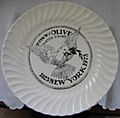
Front of the 1973 commemorative plate for the Town of Olive.
-
Back of the 1973 commemorative plate, showing the town's history and name origin.


See also
 In Spanish: Olive (Nueva York) para niños
