Denning, New York facts for kids
Quick facts for kids
Denning, New York
|
|
|---|---|

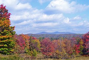
Table and Peekamoose mountains, the southernmost of the Catskill High Peaks, dominate the view in the town's higher ground.
|
|
| Etymology: William Denning, early landowner and settler | |

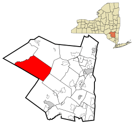
Location of Denning within Ulster County and the state of New York
|
|

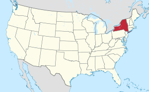
Location of New York in the United States
|
|
| Country | United States |
| State | New York |
| County | Ulster |
| Area | |
| • Total | 105.77 sq mi (273.93 km2) |
| • Land | 105.67 sq mi (273.67 km2) |
| • Water | 0.10 sq mi (0.26 km2) |
| Elevation | 1,960 ft (600 m) |
| Highest elevation | 3,847 ft (1,173 m) |
| Lowest elevation | 960 ft (290 m) |
| Population
(2020)
|
|
| • Total | 493 |
| • Density | 4.661/sq mi (1.7997/km2) |
| Time zone | UTC-5 (Eastern (EST)) |
| • Summer (DST) | UTC-4 (EDT) |
| ZIP Code(s) |
12740
|
| Area code(s) | 845 |
| FIPS code | 36-111-20247 |
| FIPS code | 36-20247 |
| GNIS feature ID | 0978897 |
| Wikimedia Commons | Denning, New York |
Denning is a quiet town located deep within the beautiful Catskill Mountains in Ulster County, New York. It's a small place, with about 493 people living there as of 2020. The town was named after an early landowner, William Denning. Because Denning is inside the Catskill Park, much of its land is protected, which helps keep its population small and its nature wild.
Contents
The Story of Denning
Denning became a town in 1849. It was created from a part of another town called Shandaken. The land in this area was originally part of a large grant given to Johannes Hardenburgh way back in 1708. Later, William H. Denning, who the town is named after, bought some of this land.
A special building called the Red Hill Fire Observation Station is in Denning. It was added to the National Register of Historic Places in 2001 because of its historical importance.
Exploring Denning's Geography
Denning is a large town in terms of land area, covering about 105 square miles (273 square kilometers). Most of this area is land, with only a tiny bit of water.
Mountains and Rivers
The town is nestled in the Catskill Mountains and shares a border with Sullivan County. It's a very rugged area with lots of trees. Most people live near the hamlet of Sundown, which is by the Rondout Creek. Others live along the two branches of the Neversink River or on a high plateau.
Protected Lands
Since Denning is completely inside the Catskill Park, a lot of the land is owned by the state. This land is part of New York's Forest Preserve. This means these forests are protected and kept wild.
You can find these protected forests in two main areas:
- The Sundown Wild Forest in the eastern parts of the town.
- The Slide Mountain Wilderness Area in the central parts.
Famous Peaks
Within the Sundown Wild Forest, you'll find three important mountains known as Catskill High Peaks. These are Peekamoose, Table, and Lone mountains. Table Mountain is the highest point in Denning, reaching 3,847 feet (1,173 meters) above sea level. Just north of Denning is Slide Mountain, which is the tallest peak in all the Catskills.
A smaller mountain, Red Hill, is 2,990 feet (911 meters) high. It has a fire tower on its top. This tower is a popular spot for hikers. It's the only place in Denning listed on the National Register of Historic Places.
Denning's Population
| Historical population | |||
|---|---|---|---|
| Census | Pop. | %± | |
| 1850 | 447 | — | |
| 1860 | 1,073 | 140.0% | |
| 1870 | 1,044 | −2.7% | |
| 1880 | 1,036 | −0.8% | |
| 1890 | 897 | −13.4% | |
| 1900 | 782 | −12.8% | |
| 1910 | 615 | −21.4% | |
| 1920 | 419 | −31.9% | |
| 1930 | 292 | −30.3% | |
| 1940 | 300 | 2.7% | |
| 1950 | 233 | −22.3% | |
| 1960 | 215 | −7.7% | |
| 1970 | 297 | 38.1% | |
| 1980 | 474 | 59.6% | |
| 1990 | 524 | 10.5% | |
| 2000 | 516 | −1.5% | |
| 2010 | 551 | 6.8% | |
| 2020 | 493 | −10.5% | |
| U.S. Decennial Census 2020 | |||
In 2000, there were 516 people living in Denning. These people lived in 215 households, and 124 of those were families. The town had about 517 housing units.
About half of the households (49.8%) were married couples living together. Some households (18.1%) had children under 18 living with them. The average household had about 2.25 people.
The population included people of different ages. About 17.4% were under 18 years old, and 17.4% were 65 years or older. The average age in Denning was 43 years.
Communities and Locations in Denning
Denning has several small communities and hamlets:
- Branch: A small community on County Road 47, northeast of Frost Valley.
- Bull Run: A community north of Sundown on New York State Route 42. Its name was changed to "Bullrun" and then to "Peekamose" in 1904.
- Denning: This hamlet is located by the East Branch of the Neversink River.
- Frost Valley: Another community found on County Road 47.
- Greenville: A community near the eastern edge of the town on County Road 46.
- Ladleton: A hamlet by the East Branch of the Neversink River, southwest of Denning village.
- Peekamose: A community near the eastern town line on New York State Route 42. Its post office was once called "Bull Run."
- Sundown: A community near the southern town line on County Road 46.
See also
 In Spanish: Denning (Nueva York) para niños
 | William M. Jackson |
 | Juan E. Gilbert |
 | Neil deGrasse Tyson |


