Esopus, New York facts for kids
Quick facts for kids
Esopus, New York
|
|
|---|---|
| Town of Esopus | |

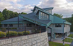
Esopus Town Hall
|
|

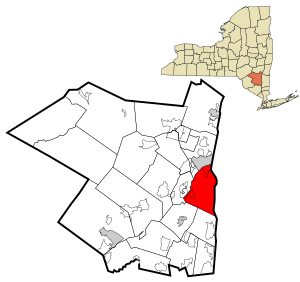
Location in Ulster County and the state of New York.
|
|
| Country | United States |
| State | New York |
| County | Ulster |
| Area | |
| • Total | 41.94 sq mi (108.62 km2) |
| • Land | 37.31 sq mi (96.64 km2) |
| • Water | 4.63 sq mi (11.99 km2) 11.08% |
| Elevation | 650 ft (198 m) |
| Population
(2020)
|
|
| • Total | 9,548 |
| • Density | 255.91/sq mi (98.80/km2) |
| Time zone | UTC-5 (Eastern (EST)) |
| • Summer (DST) | UTC-4 (EDT) |
| ZIP code |
12429
|
| Area code(s) | 845 |
| FIPS code | 36-24691 |
| GNIS feature ID | 0978944 |
Esopus (pronounced eh-SOHP-əs) is a town in Ulster County, New York, United States. In 2020, about 9,548 people lived there.
The town is named after the local indigenous tribe. Their language, Lenape, means "Wellspring of Creation." The Esopus people were part of the Lenape (Delaware) bands. They lived in areas from western Connecticut to parts of New Jersey and Pennsylvania.
Esopus is located on the west bank of the Hudson River. It is south of the city of Kingston. The main part of the town is in Port Ewen. US Route 9W runs along the eastern side of the town.
Contents
History of Esopus
Esopus became an official town on April 5, 1811. It was created from land that was once part of Kingston. Later, in 1818, some land was given back to Kingston, and a part of Hurley was added. In 1842, a section of New Paltz was also added, making Esopus mostly what it is today.
The first known European settler in the area was a trapper named Christoffel "Kit" Davits. He traded with the Esopus people. Around 1652 or 1653, many settlers moved to Esopus from the Manor of Rensselaerswyck.
During the American Revolution, a colonial prison was set up in Esopus in 1777. This was to hold prisoners from a crowded ship nearby. The British army attacked the settlement that same year and burned it down.
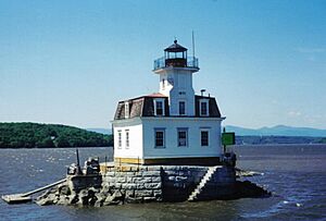
Several important buildings in Esopus are listed on the National Register of Historic Places. These include the Cumming-Parker House, Esopus Meadows Lighthouse, and the Reformed Protestant Dutch Church of Klyne Esopus. The Mount Academy is another notable building in the town.
Famous People from Esopus
In the early 1800s, Esopus was a popular summer spot for rich American families. Families like the Astors, Durkees, Paynes, and Rockefellers built large homes there. These mansions were on the west bank of the Hudson River.
Many famous people have lived in Esopus:
- John Burroughs: A well-known naturalist who studied nature.
- Sojourner Truth: A brave woman who fought against slavery.
- Colonel Oliver Hazard Payne: A treasurer for Standard Oil, a big oil company.
- The Smith Brothers: They invented the first cough drops in America.
- Saint Frances Xavier Cabrini: The patron saint of immigrants.
- Major Gen. Daniel Butterfield: He helped start the American Express Company. He also wrote the famous bugle call "Taps."
- John Jacob Astor III: A very wealthy businessman.
- Floyd Patterson: A famous boxing champion.
- Alton Brooks Parker: A lawyer and judge who ran for U.S. president in 1904.
More recently, Esopus has become a home for artists and performers:
- Frances McDormand: An actress who has won many awards, including an Academy Award.
- Kelli O'Hara: A singer and actress famous for her work on Broadway.
- Sebastian Roché: An actor.
- Joel Coen: A well-known director.
- Peter Dinklage: An actor who has won an Emmy Award.
- Luann de Lesseps: A reality television personality.
Esopus and the United Nations
In 1946, Esopus was considered as a possible location for the United Nations headquarters. Many towns in New York State and other countries were also being looked at. A photo in a local newspaper showed how beautiful the area was.
However, many local property owners did not want the UN headquarters there. They were worried about their land being taken for the project. In the end, John D. Rockefeller Jr. donated money for land in Manhattan. This land became the current UN headquarters in 1948.
Geography of Esopus
The town of Esopus covers about 41.9 square miles (108.6 square kilometers). Most of this area is land, and about 11% is water.
The eastern border of the town is the Hudson River. This river also separates Esopus from Dutchess County. The Rondout Creek forms the northern border of the town. The Wallkill River makes up the western border.
The lowest point in Esopus is the shore of the Hudson River, which is at sea level. The highest point is Hussey Hill, which is 906 feet (276 meters) high. Hussey Hill is part of the Marlboro Mountains. These mountains run through the middle and eastern parts of Esopus.
Esopus also has three lakes: Esopus Lake, Mirror Lake, and Louisa Pond. Esopus Lake and Mirror Lake are in Ulster Park. Louisa Pond is located west of the hamlet of Esopus.
Population Changes
| Historical population | |||
|---|---|---|---|
| Census | Pop. | %± | |
| 1820 | 1,513 | — | |
| 1830 | 1,770 | 17.0% | |
| 1840 | 1,939 | 9.5% | |
| 1850 | 2,900 | 49.6% | |
| 1860 | 4,734 | 63.2% | |
| 1870 | 4,557 | −3.7% | |
| 1880 | 4,736 | 3.9% | |
| 1890 | 4,659 | −1.6% | |
| 1900 | 4,907 | 5.3% | |
| 1910 | 4,732 | −3.6% | |
| 1920 | 3,913 | −17.3% | |
| 1930 | 4,167 | 6.5% | |
| 1940 | 4,220 | 1.3% | |
| 1950 | 4,738 | 12.3% | |
| 1960 | 6,597 | 39.2% | |
| 1970 | 6,974 | 5.7% | |
| 1980 | 7,605 | 9.0% | |
| 1990 | 8,860 | 16.5% | |
| 2000 | 9,331 | 5.3% | |
| 2010 | 9,041 | −3.1% | |
| 2020 | 9,548 | 5.6% | |
| U.S. Decennial Census | |||
The population of Esopus has changed over time. In 2010, about 89.1% of the people were white. About 5% were African American, and 1.4% were Asian. About 5.4% of the population was Hispanic or Latino.
By 2020, the population was 9,548. About 84.50% of the people were White. About 4.58% were Black or African American. About 6.32% of the population was Hispanic or Latino.
Emergency Services
The town of Esopus has five fire districts. These are Connelly, Esopus, Rifton, St. Remy, and Port Ewen. Volunteer ambulance services provide emergency medical help to the community.
Transportation
The main road that runs north and south through Esopus is U.S. 9W.
Until the early 1950s, the New York Central railroad ran trains through Esopus. These trains stopped at places like West Park, Esopus, Ulster Park, and Port Ewen. Since 1958, this train line has only been used for carrying goods.
Hamlets in Esopus
Esopus is made up of several smaller communities called hamlets:
- Connelly – A hamlet in the northeastern part of town. It is on the south bank of Rondout Creek.
- Dashville – A hamlet located south of Rifton.
- Esopus – A hamlet by the Hudson River, located on Route 9W.
- New Salem – A hamlet at the northern edge of the town, near Rondout Creek.
- Port Ewen – A hamlet in the northeastern part of the town. It is considered a suburb of Kingston.
- Rifton – A hamlet in the western part of the town, on Route 213.
- St. Remy – A hamlet located south of New Salem.
- Sleightsburgh – A hamlet at the northeastern corner of the town. It is at the mouth of Rondout Creek.
- Ulster Park – A hamlet north of Esopus hamlet on Route 9W.
- Union Center – A hamlet located west of Ulster Park.
- West Park – A hamlet south of Esopus hamlet on Route 9W.
See also
 In Spanish: Esopus para niños
 | Sharif Bey |
 | Hale Woodruff |
 | Richmond Barthé |
 | Purvis Young |


