
Marlboro Mountains facts for kids
Quick facts for kids Marlboro Mountains |
|
|---|---|

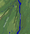
Illinois Mountain, the second highest ridge of the Marlboro Mountains, seen from Tony Williams Park in Lloyd, New York.
|
|
| Highest point | |
| Peak | Marlboro Mountain |
| Elevation | 1,127 ft (344 m) |
| Dimensions | |
| Length | 25 mi (40 km) north–south |
| Geography | |
| Country | United States |
| State | New York |
| Geology | |
| Age of rock | Ordovician |
| Type of rock | Sedimentary |
The Marlboro Mountains, sometimes called the Marlborough Mountains, are a chain of hills in New York. They stretch about 25 miles (40 km) from Newburgh to just south of Kingston, New York. These mountains are part of the larger Appalachian Mountains.
The Marlboro Mountains rise over 1,100 feet (335 meters) high. They form a natural barrier west of the Hudson River. They also help divide the Hudson Valley from the Wallkill Valley to the west. The mountains are known for their great views of the surrounding area.
Contents
Exploring the Marlboro Mountains' Geography
The Marlboro Mountains form a broken line of hills. They run from the border of Ulster and Orange Counties in the south. In the north, they reach the mouth of Rondout Creek.
The southern part of the range, about 9 miles (14 km) long, is called Marlboro Mountain. This is where the range gets its name. North of Marlboro Mountain is Bailey's Gap. This gap separates Marlboro Mountain from Illinois Mountain. Illinois Mountain is about 3+1⁄2 miles (5.6 km) long.
Further north, there is a small break in the hills. After this, the land rises again to several unnamed hilltops. These are west of West Park, New York. North of this section is Shaupeneak Mountain. It bends towards the north-northwest. It then reaches an area called The Hell. This is a gap where a creek flows through the ridge. North of this gap is Hussey Hill. It stretches to an area west of Port Ewen, New York. This marks the northern end of the Marlboro Mountains.
What's in a Name? The Mountains' History

The name "Marlboro" comes from "Marlborough" in England. The mountains are named after the town of Marlborough, New York. This town was named after the Duke of Marlborough.
The names of the individual hills in the Marlboro Mountains have interesting stories. Some names come from European settlers, and others from Native American languages.
Hussey Hill's History
Hussey Hill is named after Frederick Hussey. He was a Dutch colonial settler. In 1685, he owned land that reached the base of this hill.
Shaupeneak Mountain's Meaning
Shaupeneak Mountain has a Munsee Lenape Native American name. The name comes from Shaupeneak Falls, a waterfall on the mountain. The name "shau-pe-neak" likely means 'waterfall on the prominence'. "Shau" might mean forceful current, "pe" means water, and "neak" means a prominent point of land.
Illinois Mountain's Story
Illinois Mountain is named after the state of Illinois. In the early 1800s, many people from New England moved west. They were heading to places like Illinois and Ohio. Some settlers stopped in this area, just west of the Marlboro Mountains. They named local places after the lands they hoped to reach. Ohioville, New York is another example of a place named this way.
How People Have Used the Mountains
People have lived in and used the Marlboro Mountains for thousands of years. In the past two centuries, people used the mountains more intensely. They harvested timber, hunted game, and farmed the land.
Today, there is less farming and logging. Because of this, some parts of the mountains are returning to a more natural state. An information board at the Shaupeneak Ridge Cooperative Recreation Area explains this history:
MARLBORO MOUNTAINS: SHAPED BY PEOPLE. Humans too have worked on the Marlboro Mountains. Long ago they logged most of the mountain’s hemlock trees to tan leather. They planted fields and orchards whose outlines can still be traced through stone walls running deep through the forest. In fact, Shaupeneak Ridge was once a populated area known as Poppletown. Today, cell towers atop the ridge add a new and controversial human presence to the landscape. Yet despite many intrusions, Shaupeneak’s busy natural workshop has staged a remarkable comeback. Today it is closer to its natural condition than at any time during the last 200 years.
–Scenic Hudson Land Trust
The mountains have also offered a quiet escape. The famous naturalist John Burroughs built a cabin retreat called Slabsides here. He used it during the summer.
The Hussey Hill Gold Rush

In the 1870s, there was a brief "gold fever" at Hussey Hill. A chemist from Kingston, Edgar Eltinge, claimed he found gold there. He and another man, Royal Dimmick, started the Hudson River Gold & Silver Mining Company in 1877.
They claimed to find gold, but not enough to cover their costs. The mine closed after only 18 months. Later, Dimmick's son claimed he could sense gold deposits. He led others on trips to find gold, but they were not successful.
In 1879, a new company, the Home Gold and Silver Mining Company, took over. They raised a lot of money from investors. They held public showings of their digging operations. However, no real gold was ever proven to be found.
The last attempt to find gold at Hussey Hill was in 1891. A farmer named Conrad Burger claimed he found gold on his land. A sample was sent to New York City and confirmed to have gold. But it was unclear if the rock really came from Hussey Hill. Still, Burger sold a lease to three men hoping to strike it rich.
Understanding the Mountains' Geology
The Marlboro Mountains were formed about 450 million years ago. They are made mostly of sand and mud that settled in shallow seas. Over millions of years, these layers of sediment tilted and lifted up. Rain and wind then wore away the softer rock. This created the mountains we see today.
The mountains are a type of geological formation called a dip slope. The layers of rock tilt towards the west. A very hard layer of rock, called cap rock, is on top. This cap rock wears away slowly. It protects the softer layers underneath from eroding quickly. This is why the mountains have a unique shape. They have gentle slopes on their western side and steep slopes on their eastern side.
The hard cap rock is made of the Quassaic Group of rocks. This group includes tough sandstone and quartzite. Quartzite is sandstone that has been hardened by heat and pressure. It is very resistant to erosion. This type of rock is common in other parts of the Appalachian Mountains.
Fun Activities in the Marlboro Mountains
The Marlboro Mountains offer many outdoor activities for people in the Mid Hudson Valley. You can enjoy hiking, cross-country skiing, and fishing here.
Here are some popular recreation areas and trails:
- Shaupeneak Ridge Cooperative Recreation Area
- John Burroughs Nature Sanctuary at Slabsides
- Hudson Valley Rail Trail
- Hemlock Ridge Multiple Use Area
Recently, the Scenic Hudson organization helped protect more land on Illinois Mountain. New trails are being built on Illinois Mountain. The goal is for hikers and cyclists to reach the summit from the Hudson Valley Rail Trail.
Images for kids
-
Map showing the Marlboro Mountains region
-
Hussey Hill seen from Port Ewen, New York
