Hudson Valley Rail Trail facts for kids
Quick facts for kids Hudson Valley Rail Trail |
|
|---|---|
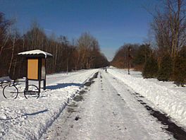
The trail by the Commercial Avenue parking lot
|
|
| Length | 4 mi (6.4 km) |
| Location | Lloyd, Ulster County, New York |
| Trailheads |
|
| Use | Hiking, bicycling, horseback riding, roller blading, and cross country skiing. |
| Sights |
|
| Website | hudsonvalleyrailtrail.net |
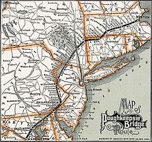
The Hudson Valley Rail Trail is a paved path about 4 miles (6.4 km) long in Ulster County, New York. It runs from the Hudson River through the town of Lloyd and the hamlet of Highland. This trail was once part of a railway line called the Poughkeepsie Bridge Route. This route used to cross the Hudson River on the Poughkeepsie Bridge.
Over many years, different railroad companies owned this railway. But after a fire in 1974, the bridge became unusable for trains. By the 1980s, the railway company Conrail stopped using this route. They wanted to sell the bridge and the land it used. In 1984, the property was sold for just one dollar to someone who didn't take care of it or pay taxes. Because of this, Ulster County took control of the western part of the railway land in 1991. They then gave it to the town of Lloyd.
In the 1990s, a company that wanted to lay fiber optic cables paid the town to use the old railway path. The town used some of this money to pave the path, and it opened as a public rail trail in 1997. A local Rotary club helped a lot, building a pavilion and adding an old caboose (the last car on a freight train). The trail was first shorter, but it was extended between 2009 and 2010. This extension connected it all the way to the Poughkeepsie Bridge. Money from a special government fund helped pay for this extension.
The Poughkeepsie Bridge is now a walking path called the Walkway Over the Hudson. It connects the Hudson Valley Rail Trail to the Dutchess Rail Trail on the other side of the river. Together, they form a large rail trail system that crosses the Hudson. The Hudson Valley Rail Trail is also part of the larger Empire State Trail. As it goes through Highland, the trail crosses several bridges and passes by a wetlands complex. There are also four parking areas for visitors.
Contents
History of the Trail
From Rails to Trails
The Hudson Valley Rail Trail follows the path of the old Poughkeepsie Bridge Route. This railway ran through Highland in the town of Lloyd. It crossed the Hudson River on the Poughkeepsie Bridge. Highland has always been a busy area in Lloyd. Many different railroad companies used this route over the years.
Later, a company called Penn Central owned the railway. They preferred to send trains on a northern route through Selkirk. This was because new technology made the Selkirk route more efficient. The Poughkeepsie route used to be very important for shipping goods to New England. The nearby Maybrook rail yard was once one of the biggest east of the Mississippi River. However, train traffic over the Poughkeepsie Bridge completely stopped after a fire damaged the bridge in 1974.
After Penn Central went out of business, Conrail took over the railway. But they didn't want to spend money fixing the bridge. Train traffic near the bridge stopped in 1982. The tracks were removed the next year. Conrail then sold the Poughkeepsie Bridge and the land around it for just one dollar in 1984. The new owner did not pay taxes or maintain the property. In 1990, he went out of business and sold it to a friend for one dollar. This friend also did not pay taxes. So, in 1991, Ulster County took control of the railway land west of the bridge. They gave about 5 miles (8 km) of this abandoned land to the town of Lloyd.
Building the Trail
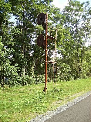
Before the land was given to Lloyd, some parts of the old railway were sold off. The remaining land was then turned into a rail trail. About $400,000 was raised to build the trail. This money came from a deal where a company paid the town to lay fiber optic cables under the path. Only $70,000 was needed to pave the trail. The path is still used for these fiber optic lines today.
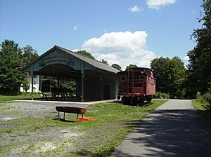
The Rotary club in Highland strongly supported building the trail. They have since built helpful things for trail users, like a pavilion, a garden, and a parking lot. The path officially opened as a trail in 1997. It was first about 2.5 to 3 miles (4 to 4.8 km) long. It ran from Riverside Road in the west to Vineyard Avenue in the east. At first, the trail couldn't go all the way to the Poughkeepsie Bridge because of a missing overpass and a blocked bridge.
In 2000, Lloyd received a grant of $224,000 from the state and federal governments to connect the trail to the bridge. More money, $1.5 million, was given in 2006 to build a bridge, a tunnel, and finish the path. Lloyd also received grants in 2002 and 2005 to extend the trail west to the Black Creek Wetlands Complex.
In 2006, a local business person gave an old caboose to the trail association. This caboose was built in 1915 and was one of the first made of steel. It was placed next to the pavilion. In 2007, a study found that the caboose's paint contained lead. The paint was later replaced, and the caboose was repaired for $4,500. Another caboose from 1926 is located at the Haviland Road parking lot.
In 2007, Lloyd's police department bought a Segway to patrol the rail trail. The police chief felt it would help officers patrol for longer. Seven officers were trained to use the Segway, which can go up to 12.5 mph (20 km/h) and carries a special device to help people in emergencies. The trail has sometimes been damaged by graffiti.
In March 2009, Ulster County received almost $21 million in government funds. This included $3.16 million to finish the trail between Lloyd and the Poughkeepsie Bridge. Some money for planning came from the town's fiber optic deal. The Rail Trail Association also received a grant to print brochures. Construction for this 1.28-mile (2.06 km) section began in September 2009. In March 2010, a part of New Paltz Road was closed to replace a bridge over the trail.
The official start of construction for the extension was on May 4, 2010. The trail was expected to be finished by October. A bridge over Vineyard Avenue opened for walkers on July 16, 2010. The last part to be finished was a bridge carrying Mile Hill Road over the trail. The crossing at US 9W was also fixed, allowing users to go over or under the highway. To celebrate the opening of the Vineyard Avenue bridge, a section of Route 44–55 was closed for the day. The eastern extension officially opened on October 2, 2010.
Between June 23 and 24, 2011, parts of the trail were spray-painted with many words and images. Volunteers helped clean up some of the graffiti. The town supervisor said this incident would make local residents feel a stronger connection to the trail.
As part of the Empire State Trail project, the trail was extended about 2 miles (3.2 km) to the west. It now ends just past the New York State Thruway in New Paltz. There are also connections to the Wallkill Valley Rail Trail. This means there is now a direct link between the Poughkeepsie Bridge and the Wallkill Valley area. Future plans include developing shops along the trail and connecting it to Illinois Mountain.
Trail Route and Features
The Hudson Valley Rail Trail runs east to west. It starts at the Poughkeepsie Bridge, near Haviland Road. The Poughkeepsie Bridge is 1.28 miles (2.06 km) long and opened as a walking path in 2009. This bridge is a National Recreation Trail. It connects to the Dutchess Rail Trail on the east side of the river. Together, they form a continuous 18.2-mile (29.3 km) rail trail system across Ulster and Dutchess counties.
The Hudson Valley trail continues about 0.5 miles (0.8 km) west from the Poughkeepsie Bridge. It then goes over a bridge on Mile Hill Road, and then another 0.1 miles (0.16 km) to a crossing at US 9W. At the 1-mile (1.6 km) mark, the trail reaches a bridge over Vineyard Avenue. About 1.5 miles (2.4 km) from this bridge, the trail goes under New Paltz Road. Almost 0.5 miles (0.8 km) from this road, the trail reaches the Black Creek Wetlands Complex.
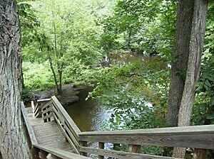
Black Creek is one of the two main streams in Lloyd. It flows north through the town and forms a pond. The wetlands complex is important for water drainage. It includes Plutarch Swamp and a large bog with rare plant species. The complex also includes the Swarte Kill, Lloyd's second major waterway. The trail continues another 0.5 miles (0.8 km) past the start of the complex to Tony Williams Park.
The trail was extended about 2 miles (3.2 km) west as part of the Empire State Trail project. This part runs next to New York State Route 299. It ends just west of the New York State Thruway in New Paltz. There are connections to the Wallkill Valley Rail Trail from this western end.
There are five parking areas along the trail. These are located by Haviland Road, Commercial Avenue, the Rotary pavilion, Tony Williams Park, and along Route 299 in Lloyd. The trail is 12 feet (3.7 m) wide and 4 miles (6.4 km) long. It is paved with asphalt. It is great for hiking, bicycling, horseback riding, roller blading, and cross country skiing.
In 2018, a local law firm published an updated map. This map showed the planned route of the Hudson Valley Rail Trail. It also showed how it connects the Wallkill Valley Rail Trail and River-to-Ridge-Trail with the Dutchess County Rail Trail.
See also
 In Spanish: Hudson Valley Rail Trail para niños
 | Bessie Coleman |
 | Spann Watson |
 | Jill E. Brown |
 | Sherman W. White |


