Balsam Lake Mountain facts for kids
Quick facts for kids Balsam Lake Mountain |
|
|---|---|
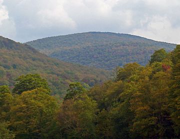
Balsam Lake Mountain looking up Clark Hollow from Mill Brook Road to the northwest
|
|
| Highest point | |
| Elevation | 3,730 ft (1,140 m) |
| Prominence | 480 ft (150 m) |
| Listing | Catskill High Peaks #16 |
| Geography | |
| Location | Hardenburgh, New York |
| Parent range | Catskill Mountains |
| Topo map | USGS Seager |
| Geology | |
| Age of rock | 250-350 mya |
| Mountain type | Mature dissected plateau |
| Climbing | |
| Easiest route | Old road to fire tower |
Balsam Lake Mountain is a cool mountain in the Catskill Mountains of New York, United States. It's located in a town called Hardenburgh. This mountain is the most western of the 35 highest peaks in the Catskills, known as the Catskill High Peaks. Its exact height isn't known for sure, but maps show it's around 3,720 feet (1,134 meters) tall.
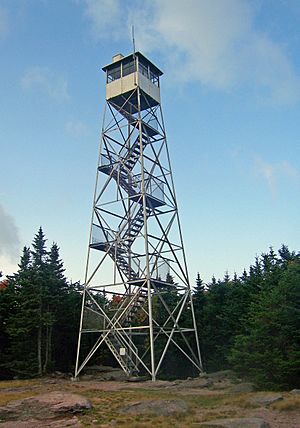
This mountain is part of the Balsam Lake Mountain Wild Forest, which is a protected area. Long ago, in the late 1800s, people built the very first fire lookout tower in New York State on its top. This tower helped spot forest fires. The state later took over and built better towers. One of these towers is still there today and is a historic landmark. It hasn't been used to spot fires since 1988.
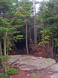
On the summit, there's also a rare sphagnum bog (a type of wetland). This bog has been affected by acid rain because a big windstorm in the 1950s blew down the trees that protected it.
Even though it's in a remote area, the fire tower and its amazing views make Balsam Lake Mountain a popular spot for hikers. Many hikers are "peakbaggers" who want to climb all the Catskill High Peaks. Balsam Lake Mountain is one of the peaks they must climb to join the Catskill Mountain 3500 Club.
Contents
Where is Balsam Lake Mountain?
Balsam Lake Mountain is in the middle of a long mountain range. This range starts at Barkaboom Mountain in the west and goes all the way to Doubletop Mountain in the east. The mountain rises from a base that is over 2,000 feet (610 meters) high. There are lower spots, called "cols," between it and nearby peaks.
Many small streams start in the narrow valleys around the mountain. The biggest valley is Clark Hollow, on the northwest side. The mountain has steep valley slopes mixed with gentler ridges.
What is the summit like?
The very top of the mountain, above 3,600 feet (1,100 meters), is quite flat. It looks a bit like a large "T" shape. To the west, there's a steep drop to a low spot between Balsam Lake Mountain and Mill Brook Ridge.
Streams from Balsam Lake Mountain flow into the Delaware River. For example, Mill Brook on the north side feeds into the East Branch of the Delaware River. This water is an important part of New York City's drinking water. Streams on the south side flow into the Beaver Kill.
Who owns the land?
Most of the southern and northwestern parts of the mountain are owned by the state of New York. The New York State Department of Environmental Conservation (DEC) manages this land. It's part of the 13,500-acre (5,500-hectare) Balsam Lake Mountain Wild Forest.
The northern slope of the mountain is privately owned. It belongs to the family of a famous railroad builder named Jay Gould.
What plants and animals live here?
Because Balsam Lake Mountain is quite high, its lower slopes are covered mostly by a "northern hardwood forest." This forest has trees like beech, birch, and maple. Many parts of the mountain still have "first growth" or old-growth trees. This means they have never been cut down by people.
What about the higher parts?
As you go higher up the mountain, around 3,400 to 3,600 feet (1,000 to 1,100 meters), you start to see balsam fir and red spruce trees. The hardwood trees become smaller and eventually give way to a dense "boreal forest." This forest is mostly made up of fir and spruce trees. You might also see paper birch trees and plants like wood sorrel on the ground.
Inside the forest on the summit, there's a special sphagnum bog. This bog is filled with peat mosses, mountain holly, and balsam fir trees. It's the deepest bog in the Catskills, with peat going down 24 inches (61 cm). Scientists have found that this bog is about 5,500 years old!
What animals can you find?
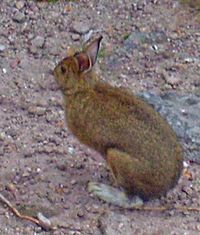
The forests on Balsam Lake Mountain are home to many animals common in the Catskills. You might see black bears and white-tailed deer. Smaller animals like rodents and rabbits, such as the snowshoe hare, also live here. Beavers have also been common over the years.
How did Balsam Lake Mountain form?
The Catskill Mountains formed a very long time ago, between 250 and 350 million years ago. This happened when sand and silt from ancient mountains collected in a large river delta. This delta slowly lifted up, and over millions of years, streams carved out valleys. This created the "dissected plateau" shape we see today. The harder rocks, like shale and sandstone, remained as the mountain tops. Later, glaciers made the valleys even steeper and smoother.
Historians say that the Balsam Lake Mountain area shows very few signs of human activity from long ago. The Iroquois people, who lived in New York first, mostly used areas below 1,500 feet (460 meters) for hunting. Early European settlers didn't build many farms here either.
The first fire tower
A very important event happened in 1887. The state bought land on the mountain for the new Forest Preserve. This meant the land would stay wild forever and never be logged. In the same year, a group called the Balsam Lake Club built a simple wooden fire lookout tower on the summit. This was the first fire tower in New York State! It helped them spot fires that could threaten the land around Balsam Lake.
Two years later, the state bought more of the mountain, including the summit itself in 1900. In 1909, the state's Forest, Fish and Game Commission took over the fire tower. About ten years later, they built the steel tower that stands there today. By 1935, the state was taking care of the road to the summit and other trails.
Changes over time
In 1950, a huge storm called the Great Appalachian Storm of November 1950 caused a lot of damage to the balsam fir trees on the summit. Many trees were blown down. Even the trees that stayed standing died faster because they were no longer protected. The bog on the summit became more open and vulnerable to acid rain.
Over the years, fewer forest fires happened because people became more aware of the danger. This meant that manned fire towers were not as needed. The state started closing them down and using planes to spot fires instead.
In 1976, the Balsam Lake Club gave a large piece of land (3,615 acres or 1,463 hectares) to a group called the Catskill Center for Conservation and Development. Three years later, the Catskill Center sold this land to the state. This made most of the mountain public land.
The fire tower on Balsam Lake Mountain was one of the last to be closed in 1988. Even after it closed, hikers still climbed it for the views. Later, people worked together to save and restore the five remaining fire towers in the Catskill Park. As part of this effort, a new trail called the Mill Brook Ridge Trail was built. This trail connects different parts of the Catskill trail system.
How can you hike Balsam Lake Mountain?
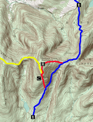
There are trails to the summit of Balsam Lake Mountain from three directions: north, south, and west. All these trails eventually lead to the Balsam Lake Mountain Trail (BLMT). This trail is a 1.6-mile (2.6 km) loop over the summit. It follows an old jeep road on the north side and a footpath on the south side.
Northern approach
The most popular way to reach the summit starts from Mill Brook Road. You follow the old jeep road to the fire tower. This trailhead is the highest in the Catskills, at 2,580 feet (786 meters). From here, it's about 2.75 miles (4.4 km) to the summit, climbing 1,120 feet (341 meters).
Southern approach
From the south, at the end of Beaver Kill Road, the hike is shorter but steeper. You follow the Dry Brook Ridge Trail north for 0.9 miles (1.4 km). Then you connect to the Balsam Lake Mountain Trail. From there, it's another 0.85 miles (1.4 km) to the summit, passing a lean-to and a spring. This route is about 1.75 miles (2.8 km) long and climbs 1,200 feet (366 meters).
Western approach
In 1998, the new Mill Brook Ridge Trail opened. This allows for a longer, more challenging 6.7-mile (10.8 km) hike from the Alder Lake trailhead to the west. This trail goes over two eastern summits of Mill Brook Ridge. Then it drops into a low spot before climbing to the Balsam Lake Mountain Trail, just south of the summit. The total climb on this route is 1,520 feet (463 meters). This trail helps connect different hiking networks in the Catskill Park.
Hikers sometimes combine climbing Balsam Lake Mountain with a hike to nearby Graham Mountain. You can reach Graham Mountain by an old road that branches off the Dry Brook Ridge Trail. Some hikers also do the entire Balsam Lake Mountain Trail loop.
Camping rules
DEC rules say you cannot camp above 3,500 feet (1,100 meters) on the mountain, except in winter. There is a lean-to (a simple shelter) and a spring on a side trail just below that elevation on the south side. Campers can also set up their tents more than 150 feet (50 meters) away from any trail or water.
 | DeHart Hubbard |
 | Wilma Rudolph |
 | Jesse Owens |
 | Jackie Joyner-Kersee |
 | Major Taylor |


