Graham Mountain (New York) facts for kids
Quick facts for kids Graham Mountain |
|
|---|---|

|
|
| Highest point | |
| Elevation | 3,868 ft (1,179 m) |
| Prominence | 1,188 ft (362 m) |
| Listing | Catskill High Peaks #7th |
| Geography | |
| Location | Hardenburgh, New York |
| Parent range | Catskill Mountains |
| Topo map | USGS Seager |
| Geology | |
| Age of rock | 250-350 mya |
| Mountain type | Mature dissected plateau |
| Climbing | |
| Easiest route | Old road to summit |
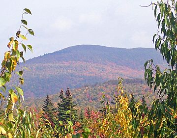
Graham Mountain is a cool mountain in the Catskill Mountains of New York. It's the seventh highest of the Catskill High Peaks. What makes it special is that it's the tallest privately owned mountain in the whole range.
The top of Graham Mountain is quite unique. It has a special "pygmy forest" of small hardwood trees. You won't find the usual evergreen trees that grow on other high Catskill peaks here. In the 1960s, a TV relay station was built on the summit. This station helped broadcast educational TV shows, like an early version of today's PBS. It was later abandoned, but you can still see its old ruins from nearby mountains.
Graham Mountain is part of the beautiful Catskill Park. Some parts of it are public land, called the Forest Preserve. But the very top and the main path to it are owned by the family of Jay Gould. He was a famous railroad businessman from the area. In 2021, the family decided to close the mountain to the public. Before that, climbing Graham Mountain was a requirement to join the Catskill Mountain 3500 Club, a group for hikers who climb all the highest peaks.
Contents
Exploring Graham Mountain's Geography
Graham Mountain is located near the eastern side of the Catskill range. It's part of a long ridge that includes Mill Brook Ridge. Two smaller mountains, unofficially called East and West Schoolhouse mountains, connect Graham to Balsam Lake Mountain. Balsam Lake Mountain is another high peak to the west.
Between Graham and Doubletop Mountain to the east, there's a very deep dip in the land. This low point, called a col, is about 900 feet (274 meters) lower than the mountain tops on either side.
Streams and Waterways
The sides of Graham Mountain have many streams. On the north side, you'll find deep valleys carved by creeks. The biggest one is Drury Hollow. Other streams like Flatiron Brook also flow down the north slopes. These streams are all tributaries (smaller streams that flow into a larger one) of Dry Brook. Dry Brook then flows into the East Branch of the Delaware River.
Since Dry Brook flows into the East Branch above the Pepacton Reservoir, the water from the north side of Graham Mountain helps supply New York City's drinking water.
The southern slopes of the mountain are a bit gentler. They drain into the upper parts of the Beaver Kill river. Gulf of Mexico Brook flows from the southwest side. Tunis and Vly ponds near the mountain's base also feed the Beaver Kill. The Beaver Kill eventually joins the East Branch of the Delaware River, but it does so below the reservoir. This means the water from the south side of Graham Mountain does not go into New York City's water supply.
The Summit Ridge
Graham Mountain has an L-shaped top, or summit ridge. It's quite narrow. The highest point, marked by a U.S. Geological Survey benchmark, is 3,868 feet (1,179 meters) high. This spot is near the old TV relay station ruins. The southwest end of the ridge slopes down gently before dropping steeply into the deep col towards Doubletop Mountain.
Land Ownership
Most of the northern slopes and the summit of Graham Mountain are private land. This large area was bought by George Jay Gould I, the son of Jay Gould, around 1890. It's known as Furlow Lodge and is still owned by the Gould family as a private retreat.
The southern slopes of Graham Mountain are different. Up to about 3,500 feet (1,067 meters) on the southwest side, this land is publicly owned. It's part of the Forest Preserve within the Big Indian-Beaverkill Range Wilderness Area. This means these parts are protected and open to the public.
Plants and Animals of Graham Mountain
Most of Graham Mountain's slopes are covered in a "northern hardwood forest." This forest is made up of trees like beech, birch, and maple. Because the mountain starts at a high elevation, you can find very old, "first-growth" forests (meaning they've never been cut down) higher up on Graham than on other mountains. Some of these ancient trees are found as high as 3,545 feet (1,080 meters).
The Pygmy Forest
The very top of Graham Mountain has a special "pygmy forest." This is unique in the Catskills! The trees here, like black cherry and mountain ashes, are very small, often no taller than a person. You might expect to see balsam fir trees on the summit, as they grow on nearby peaks. But on Graham, balsam firs are only found in small groups on the slopes below the top.
A forest expert named Michael Kudish has studied why balsam firs don't grow on Graham's summit. He thinks that over thousands of years, the small, twisted hardwood trees on the ridge have slowly replaced the balsam firs. This shows how forests change and evolve over time.
Animal Life
The forests on Graham Mountain are home to many animals typical of the Catskills. You might see black bears and white-tailed deer, which are larger mammals. There are also many smaller animals like snowshoe hares. Beavers have also lived here for a long time. Experts have found many signs of beaver dams and meadows on Graham's slopes and nearby areas, showing their busy work.
History of Graham Mountain
The Catskill Mountains were formed a very long time ago, between 250 and 350 million years ago. Back then, sand and mud washed down from the ancient Acadian Mountains (which were in the northeast). This material settled in a huge river delta at the edge of a shallow inland sea. This sea is now the Allegheny Plateau.
Over millions of years, the land slowly pushed upwards, a process called tectonic uplift. Then, streams and rivers carved out valleys, creating the "dissected plateau" shape we see today. The harder rocks, like shale and sandstone, remained as the mountain tops. Later, during the Ice Ages, glaciers made the valleys even steeper and smoother.
Human Impact and the Relay Station
For most of its history, Graham Mountain remained wild. But things changed in the late 1800s when Turner Hollow Road was built. This road made it easier for people to reach fishing spots on the Beaver Kill river. Around 1890, George Gould bought the large Furlow Lodge property, which included most of Graham Mountain. His father, Jay Gould, loved fishing at the lake there.
The new road also made it easier for logging companies to cut down trees on Graham's upper slopes. You can still see signs of this logging today, even at high elevations. One of the last logging projects happened in the early 1960s. This was when the TV relay station was built on the summit.
In early 1963, a technician and pilot got stuck on the summit for a whole day! Their helicopter crashed during a heavy snowstorm while they were on a maintenance trip. The station continued to operate for a few more years after that. It was finally abandoned sometime before 1969.
How to Access Graham Mountain
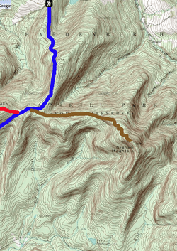
The most common way to reach Graham Mountain's summit starts from the Dry Brook Ridge Trail. You can find this trail at the Mill Brook Road crossing, which is the highest trailhead (starting point for a trail) in the Catskills at 2,580 feet (786 meters).
Hikers follow the blue-marked Dry Brook Ridge Trail for about 1.8 miles (2.9 km). This path is an old jeep road that leads towards the Balsam Lake Mountain fire tower. At an elevation of 3,340 feet (1,018 meters), an unmarked old road, called Old Tappan Road, branches off to the left.
Private Property Notice
At this point, hikers leave the public trail. The land from here to the summit of Graham Mountain is private property. In the past, you needed permission from the Furlow Lodge caretaker to continue. However, since January 2021, permission is no longer given. This means the summit of Graham Mountain is now closed to the public.
The Old Tappan Road curves around Turner Hollow, going down a bit before climbing again. It passes a fork where an older part of the road goes down into Drury Hollow. The main road continues to climb gently until about 3,400 feet (1,036 meters). Then, it gets steeper with several switchbacks (sharp turns). Along this path, you might see some of the balsam fir trees on the slope.
The Summit
The very top of Graham Mountain is marked by a U.S. Geological Survey benchmark. This metal disk, set in a rock, shows the mountain's elevation of 3,868 feet (1,179 meters). It's located at the western edge of the summit ridge, where the old road ends.
The ruins of the old TV relay station are in the middle of a large clearing. It's a one-story building made of cinderblocks with no roof left. You can still see its three steel supports from many places around the mountain. Some hikers who are part of the 3500 Club have said that Graham Mountain, along with nearby Eagle Mountain, is one of their least favorite high peaks to climb.
From the summit, you can get open views to the west, towards Balsam Lake Mountain. There are also small paths along the ridge through the pygmy forest. These paths lead to views over the Dry Brook valley and other mountains like Big Indian, Eagle, and Fir to the northwest. You can also see Doubletop Mountain and the headwaters of the Beaver Kill to the southeast.
Other Ways to Hike
Other ways to reach Graham Mountain involve "bushwhacking," which means hiking off-trail through the woods. One option is to hike from the Seager-Big Indian Trail along Dry Brook. This is often done along with climbing Doubletop Mountain. You can also combine a hike to Graham with a trip to Balsam Lake Mountain, sometimes starting from the south end of Beaverkill Road. A direct off-trail hike from there is also possible.
 | Janet Taylor Pickett |
 | Synthia Saint James |
 | Howardena Pindell |
 | Faith Ringgold |


