
Benchmark (surveying) facts for kids


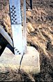
A benchmark is a special mark or object used by surveyors to show an exact height or position. Imagine it like a permanent marker on the ground that tells you how high that spot is above sea level.
The name "benchmark" comes from how they were first made. Surveyors would carve a horizontal line into stone. They could then place an "angle-iron" into this cut, creating a small "bench" for their measuring tool, called a leveling rod. This helped them measure heights very accurately from the same spot each time. These old marks often had a carved arrow pointing up to the line.
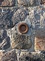
Today, benchmarks are usually made of bronze or aluminum disks. These disks are set into strong materials like stone or concrete, or attached to rods pushed deep into the ground. This makes sure they stay in place and provide a very stable reference point for height. If a height is shown on a map but there's no physical mark on the ground, it's called a spot height.
Contents
Why are Benchmarks Important?
Benchmarks are super helpful for many reasons. They help people know the exact height of different places. The height of each benchmark is carefully measured and recorded. These measurements are often shown on detailed maps.
Surveyors use benchmarks to make sure their measurements are correct. For example, when building roads, bridges, or even new neighborhoods, knowing the exact height of the land is crucial. Benchmarks provide these important starting points.
Other Types of Survey Marks
Besides benchmarks, there are other types of survey marks. One common type is a triangulation point, also known as a trig point. These marks are used to show a very precise horizontal (side-to-side) position, not just height.
Triangulation points might look like benchmark disks, but they are set flat on the ground. Sometimes, they are also used to measure height. Tall features on buildings, like the top of a church spire or a chimney, can also be used as reference points for triangulation.
In some places, like the United Kingdom, triangulation points are often large concrete markers. These markers can serve as both a triangulation point and have a benchmark built into their side. With modern tools like GPS, surveyors can now find both the horizontal and vertical position of a mark at the same time. This means many marks are now considered "fixed in three dimensions."
Who is in Charge of Benchmarks?
Benchmarks are usually placed and looked after by government agencies or special survey companies. Many governments keep a public record of these marks. This way, anyone who needs the information can find it.
These records are often found in online databases or on maps. They might include drawings, diagrams, photos of the marks, and other technical details.
Here are some of the government groups that place and keep track of benchmarks around the world:
- Canada
- Natural Resources Canada (Geodetic Survey Division)
- Denmark
- GST (Geodatastyrelsen)
- France
- Institut Géographique National
- India
- Republic of Ireland
- Ordnance Survey Ireland
- Italy
- Istituto Geografico Militare
- Japan
- Netherlands
- Netherlands Partnership Geodetic Infrastructure (NSGI)
- Directorate-General for Public Works and Water Management (for vertical measurements)
- Kadaster (for horizontal measurements)
- Netherlands Partnership Geodetic Infrastructure (NSGI)
- New Zealand
- Land Information New Zealand
- Pakistan
- South Africa
- Department of Rural Development and Land Reform
- Spain
- Instituto Geográfico Nacional (IGN)
- United Kingdom
- United States
- The National Geodetic Survey (NGS)
- The United States Army Corps of Engineers (USACE)
- The United States Forest Service
- The United States Geological Survey (USGS)
Image gallery
-
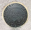
A C&GS benchmark disk in the United States.
-
A benchmark in Saint Goussaud, Limousin, France, placed by the Institut Géographique National.
-
A benchmark disk in Ottawa, Ontario, Canada.
-
A benchmark near the Port de Barcelona building in Barcelona.
-
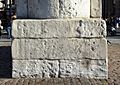
A benchmark on the base of the statue of King Charles I in Trafalgar Square, London. This spot is where distances from London are measured.
-
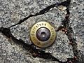
A benchmark painted on the foundation of an electricity pylon.


.jpg)


Images for kids
-
A benchmark from the Prussian Survey Authority on a church in Brandenburg.

