
Survey of India facts for kids
| Survey and mapping agency overview | |
|---|---|
| Formed | 1767 |
| Jurisdiction | Government of India |
| Headquarters | Hathibarkala Estate, New Cantt Road, Dehradun, Uttarakhand, India |
| Minister responsible |
|
| Survey and mapping agency executive |
|
| Parent department | Department of Science and Technology |


The Survey of India is a really important group in India that makes maps and measures land. It's India's main engineering agency for this work.
It was started way back in 1767 to help the British East India Company map out their lands. This makes it one of the oldest engineering departments in the Government of India. People who work here are part of a special group called the Survey of India Service. The boss of this group is called the Surveyor General of India. Right now, that's Hitesh Kumar S. Makwana.
Contents
History of Mapping India
The Survey of India has a long and interesting history. The first modern scientific survey in India happened between 1793 and 1796. It was led by John Mather. He followed instructions from Colonel Alexander Read. This survey covered an area then called Baramahal. Today, this area includes parts of Tamil Nadu.
The Great Trigonometrical Survey
One of the biggest projects was the Great Trigonometrical Survey. It started on April 10, 1802. British surveyor Colonel William Lambton began this huge task. He started from St. Thomas Mount in Chennai. The survey then moved all the way to the foothills of the Himalayas.
They used a giant tool called a Theodolite. It was 36 inches tall and weighed half a ton! It took 57 days just to measure a 12-kilometer starting line. This massive project lasted for 50 years. It was finished in 1852 under Surveyor General George Everest.
A brilliant mathematician and surveyor named Radhanath Sikdar was part of this team. In 1852, he was the first to calculate the height of Mount Everest. He found it was 29,002 feet tall. Today, we know it's about 29,037 feet. This survey marked the start of modern map-making in India. It also helped create one of the world's oldest mapping agencies.
How the Survey of India Works
The main office of the Survey of India is in Dehradun, Uttarakhand. It has 18 different divisions. These divisions handle everything from predicting ocean tides to surveying from the air. There are also 23 Geo-spatial Data Centers across India. Each center takes care of mapping its local area.
Surveyors are the most important people in the Survey of India. To become a Group 'A' officer, you need to pass a tough exam. This exam is part of the Indian Engineering Services. It is held by the Union Public Service Commission.
There are many important jobs in the Survey of India. They range from Draftsman to the top job, which is the Surveyor General.
What the Survey of India Does
The Survey of India has many important jobs.
- Helping the Government: It gives advice to the Indian Government. This advice is about all things related to maps. This includes geodesy (measuring Earth's shape), photogrammetry (making maps from photos), and map-making.
- Naming Places: This agency decides how geographical places in India are named. It also makes sure their spellings are correct.
- Checking Maps: They check and approve maps made by other groups. This includes maps from private companies. They make sure India's borders and coastlines are shown correctly. They also publish tide tables a year in advance.
- Doing Surveys: They carry out many types of surveys. This includes topographical maps (showing land features). They also make maps for forests, army areas, and big cities. They help with development projects too.
- Defining Borders: The Survey of India helps mark the borders of India. They also advise on borders between different states within India.
- Predicting Tides: They predict ocean tides for 44 ports. This includes 14 ports in other countries.
- Research and Development: They do research to improve mapping technology. This includes new ways to use photos for maps.
- Training People: They train people from central and state government groups. They also train people from other countries.
Maps from the Survey of India
The Survey of India publishes many maps. Some maps are "unrestricted." You can buy these from their data centers. Other maps are "restricted." You need special permission from the government to get these.
There are also rules about buying and using these maps. For example, only Indian citizens can buy topographic maps. These maps cannot be taken out of India. However, in February 2021, the Indian Government made some changes. These changes made it easier to get and use maps. They are still working on the exact new rules.
Gallery
-
Old logo of the Survey of India
-
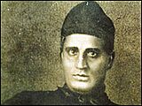
Radhanath Sikdar, a mathematician who first calculated the height of Mount Everest in 1852.
-

William Lambton (1753 – 19 January 1823) started Great Trigonometrical Survey (1802–1852).


See also
- Indian Institute of Surveying & Mapping (IIS&M)
- Survey of India Service
- Cartography of India
- Linguistic Survey of India
