
Geodesy facts for kids


Geodesy (say: jee-OH-duh-see), also called geodetics, is a special science. It is part of geography. Geodesy is all about carefully measuring and describing the surface of our Earth.
Imagine trying to make a super accurate map of the whole world. That's what geodesy helps us do! It looks at the Earth's exact shape. It also studies how the Earth's pull of gravity works everywhere.
Some scientists who work in geodesy also study how the Earth changes. They might look at how the Earth's crust moves. They also study tides in the oceans. Another topic is the way the geographical poles of the Earth slowly move.
Contents
What is Geodesy?
Geodesy is like the Earth's personal measuring tape. It helps us understand the Earth's size and shape. It also tracks how the Earth changes over time. This science is super important for many things we use every day.
Why is Geodesy Important?
Geodesy helps us create accurate maps. It also makes GPS (Global Positioning System) work. GPS helps you find your way around. It guides cars, planes, and even ships. Geodesy also helps us build bridges and tall buildings. It ensures they are placed correctly.
This science also helps us understand natural events. It can track how earthquakes change the land. It can also show how volcanoes affect the ground. Geodesy helps us study climate change. It measures things like rising sea levels.
The Earth's Shape: The Geoid
You might think the Earth is a perfect ball, but it's not! It's a bit squashed at the poles. It also bulges a little at the middle. Geodesy helps us find the Earth's true shape. This special shape is called the geoid (say: GEE-oyd).
What is the Geoid?
Imagine the ocean covering the whole Earth. This ocean would be still, with no waves or tides. The surface of this imaginary ocean is the geoid. It's a bumpy shape because of gravity. Places with stronger gravity pull the water down more. This makes the geoid lower in those spots.
The geoid is very important for measuring heights. It helps scientists know how high mountains are. It also shows how deep valleys are. All these measurements are taken from the geoid.
Measuring Gravity
Geodesy also studies the Earth's gravitational field. This is the invisible force that pulls everything down. Gravity is not exactly the same everywhere on Earth. It changes slightly depending on what's under the ground. It also changes with how high you are.
How is Gravity Measured?
Scientists use special tools to measure gravity. These tools are called gravimeters. They can detect tiny differences in gravity. By mapping these differences, scientists learn more about the Earth's inside. They can find out about different types of rocks. They can also learn about water underground.
How Geodesy Helps Us
Geodesy is a very practical science. It helps us in many ways.
- Making Maps: Geodesy provides the exact points needed to draw accurate maps. Without it, maps would be wobbly and wrong.
- GPS and Satellites: The satellites that power GPS rely on geodesy. They need to know the Earth's exact shape and gravity. This helps them send correct location signals to your phone or car.
- Self-Driving Cars: Future cars that drive themselves will need super-accurate maps. Geodesy makes these maps possible.
Understanding Earth Changes
- Sea Level Rise: Geodesists measure how much the sea level is rising. This helps us understand climate change.
- Land Movement: They track how the land moves. This is important in places with earthquakes or volcanoes. It helps us prepare for natural disasters.
- Ice Sheet Changes: Geodesy can measure how much ice sheets are melting. This also helps us understand climate change.
History of Geodesy
People have been trying to measure the Earth for thousands of years. Ancient Greeks knew the Earth was round. They even tried to measure its size.
Friedrich Robert Helmert
A very important person in geodesy was Friedrich Robert Helmert (1843-1917). He was a German scientist. Helmert helped make geodesy a modern science. He wrote important books about it. He also developed new ways to measure the Earth very precisely. He is often called the "father of modern geodesy."
Images for kids
-
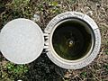
Geodetic Control Mark (example of a deep benchmark)

See also
 In Spanish: Geodesia para niños
