
Beaver Kill facts for kids
Quick facts for kids Beaver Kill |
|
|---|---|

Beaver Kill below Lew Beach
|
|

Beaver Kill within the Delaware headwaters drainage basin.
|
|
| Country | United States |
| State | New York |
| Region | Catskills |
| Counties | Ulster, Sullivan, Delaware |
| Towns | Hardenburgh, Rockland, Colchester, Hancock |
| Physical characteristics | |
| Main source | S of col between Graham and Doubletop mountains 2,760 ft (840 m) 42°1′47″N 74°32′32″W / 42.02972°N 74.54222°W |
| River mouth | East Branch Delaware River 980 ft (300 m) 41°59′24″N 74°7′52″W / 41.99000°N 74.13111°W |
| Length | 44 mi (71 km), NE-SW |
| Basin features | |
| River system | East Branch Delaware River |
| Basin size | 300 sq mi (780 km2) |
| Tributaries |
|
The Beaver Kill is a famous river in New York State, about 44 miles (71 km) long. It's a smaller river that flows into the East Branch Delaware River, which then joins the larger Delaware River. This river is well-known for its amazing trout fishing.
The Beaver Kill flows through about 300 square miles (777 km²) of the Catskill Mountains. People have loved fishing for trout here since the early 1800s. In fact, it was one of the first places in the United States to become a popular vacation spot for fishing.
Because so many people fished there, the trout population started to shrink by the 1850s. This led to early efforts to protect the river and its fish. People started introducing brown trout from fish farms to help the population grow again. The river is perfect for trout because it has many cold springs and deep pools. These keep the water cool, which trout need to survive.
Today, the town of Roscoe is a hub for fly fishing. You can find many fly-fishing shops and places to stay there. To learn more about the history of fly fishing in the area, you can visit the Catskill Fly Fishing Center and Museum in Livingston Manor.
Contents
River's Journey: Where the Beaver Kill Flows
The Beaver Kill starts in the western part of Ulster County. It begins high up, at about 2,760 feet (841 meters) above sea level. Its source is south of the area between Graham Mountain and Doubletop Mountain. These are two of the tallest peaks in the Catskill Mountains.
From Mountains to State Land
The river gently flows downhill from its source. At first, it runs through private land. Then, it enters the Big Indian-Beaverkill Range Wilderness Area. This area is part of the Forest Preserve within the Catskill Park. Soon after entering state land, the Beaver Kill gets its first small stream joining it. This unnamed stream flows steeply down from Doubletop Mountain.
The river then turns west and enters another state-owned area called the Balsam Lake Mountain Wild Forest. It flows alongside the Neversink-Hardenburgh Trail for about two miles (3 km). At the Quaker Clearing trailhead, the river turns southwest again. It then flows next to the road through a quiet valley, getting a bit wider as it goes.
Joining Other Streams
As it continues, the Beaver Kill receives water from other streams, like Alder Creek, which joins from the north. The river gradually moves more to the west. Just before reaching the Delaware County line, it turns southwest again. It then passes the small village of Lew Beach and enters Sullivan County.

The river keeps flowing in the same direction. The historic Beaverkill Bridge, a covered bridge, crosses the river at the Beaverkill State Campground. This campground is a very popular spot for fishing. After a short bend into Delaware County, the river reaches Roscoe. This is the only major town along its path.
The Famous Junction Pool
In Roscoe, the Beaver Kill's largest tributary, Willowemoc Creek, joins it from the east. This meeting point is called the Junction Pool, and it's the most famous fishing spot on the Beaver Kill. Where these two rivers meet, the Beaver Kill also becomes part of the Blue Line. This is the official boundary of the Catskill Park.
The river then starts to flow next to NY 17, a major highway. It gets wider and turns westward again, soon entering Delaware County for good. It passes the small village of Cooks Falls shortly after. The river and the highway stay close, crossing paths several times. When the river reaches the Hancock town line, the Blue Line leaves the river.
For its last few miles, the Beaver Kill bends slightly northward, still flowing alongside Route 17. At the village of East Branch, it flows into the East Branch Delaware River. This is about 10 miles (16 km) northeast of where the East Branch joins the West Branch to form the main Delaware River.
Streams That Feed the Beaver Kill
Many smaller streams, called tributaries, flow into the Beaver Kill, adding to its waters.
Tributaries from the Right Bank
- Gulf of Mexico Brook
- Black Brook
- Beecher Brook
- Scudder Brook
- Alder Creek
- Upper Beech Hill Brook
- Mary Smith Brook
- Berry Brook
- Spring Brook
- Horse Brook
- Roaring Brook
- Russell Brook
- Crystal Brook
- Horton Brook
- Spooner Brook
- Twadell Brook
Tributaries from the Left Bank
- Shin Creek
- Voorhees Brook
- Jersey Brook
- Willowemoc Creek
- Abe Wood Brook
- Cook Brook
- Whirling Eddy Brook
- Roaring Brook
- Trout Brook
Beaver Kill's Past: A River's Story
The Beaver Kill area was mostly wild and undeveloped until the 1800s. This was partly because it was far away from cities. Also, there were many arguments over who owned the land in the Catskills. Only loggers and trappers visited the area, using a road built in 1815.
Early Visitors and Industries
These early visitors told stories of the river's clear water and many trout. In 1819, writer Washington Irving even wrote about the Beaver Kill. He noted that its remote location kept it safe from city people who were just starting to enjoy angling (fishing).

Later in the 1800s, the first major industries in the valley started to affect the river. Tanneries opened up. They used the bark from the many hemlock trees to make leather. There were eventually eight tanneries in the valley. Their waste products made the river cloudy, which was bad for the trout. People making charcoal also released acids into the river, further harming its quality. These industries were successful enough to support small towns like Beaverkill and Shin Creek (now Lew Beach). The oldest bridge over the river, the Beaverkill Bridge, was built in 1865.
Conservation and Tourism
By the 1880s, these industries began to disappear. This was because technology changed, and most of the trees had been cut down. In the same decade, New York State created the Forest Preserve. This meant that state-owned land in the Adirondacks and Catskills would be kept wild forever. This focus on conservation helped the region start a new tourism economy.
Railroads, and later cars, brought dry-fly fishermen to the valley. Many early writers about this new sport, like Theodore Gordon, wrote about the trout in the Beaver Kill. They especially loved the Junction Pool, which was full of fish. The state even built the Beaverkill campground in the 1920s. It was one of the first campgrounds in the Catskill Park, designed to help manage the impact of many anglers.

Protecting the River's Future
After World War II, the Beaver Kill and Willowemoc rivers faced a new threat. New York City planned to build dams on them to get more drinking water. However, the fly-fishing community strongly opposed this. When tests showed that the ground in these valleys couldn't support the huge dams needed, the city changed its plans. Instead, it built the Cannonsville and Pepacton reservoirs on other parts of the Delaware River.
Later, anglers also protested when the Quickway (part of Route 17) was built along the river. Their efforts led to some small changes in the highway's path. Near Cooks Falls, the two roadways were even built one above the other in a narrow space between state forest land and the river. While some worried about increased runoff and changes to stream flows, the highway itself doesn't seem to have caused major harm to the river.
Images for kids
-
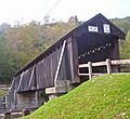
Beaverkill Bridge, built in 1865
-
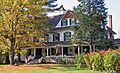
The Beaverkill Valley Inn, a historic fishing hotel
