West Branch Delaware River facts for kids
Quick facts for kids West Branch |
|
|---|---|

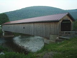
West Branch flowing under the Hamden Covered Bridge
|
|

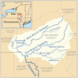
Map of the upper Delaware River watershed, showing major tributaries
|
|
| Native name | Mohock Branch |
| Country | United States |
| State | New York |
| Region | Catskills |
| Counties | Schoharie, Delaware |
| Towns | Stamford, Delhi, Hancock, Deposit |
| Physical characteristics | |
| Main source | Unnamed pond North of Mount Jefferson 42°27′16″N 74°36′01″W / 42.45444°N 74.60028°W |
| River mouth | Delaware River Hancock 883 ft (269 m) 41°56′20″N 75°16′45″W / 41.9389755°N 75.2790615°W |
| Length | 90 mi (140 km) |
| Discharge (location 2) |
|
| Basin features | |
| River system | Delaware River |
| Basin size | 666 sq mi (1,720 km2) |
| Tributaries |
|
The West Branch Delaware River is a major river that helps form the larger Delaware River. It flows for about 90 miles (144 km) through parts of New York and Pennsylvania. This river winds through the beautiful Catskill Mountains in New York.
It eventually joins the East Branch of the Delaware River. This meeting point is near the border of Pennsylvania and New York. A large part of the river is held back by the Cannonsville Dam. This creates the Cannonsville Reservoir, which is an important source of drinking water for New York City.
Contents
Journey of the River
The West Branch Delaware River begins in Schoharie County, New York. It then flows generally southwest into Delaware County. Along its path, it passes by towns like Stamford and Delhi.
River's Path Through Mountains
As the river continues through southwestern Delaware County, it becomes very winding. It flows through the mountains, generally heading southwest. Near Stilesville, the river is dammed to form the Cannonsville Reservoir.
Joining the Delaware River
At Deposit, the river makes a sharp turn to the southeast. It then flows alongside New York State Route 17. Finally, the West Branch joins the East Branch at Hancock. This is where the main Delaware River officially begins. For its last 6 miles (10 km), the river forms part of the border between New York and Pennsylvania.
River Flow and Water Levels
The United States Geological Survey (USGS) keeps track of the water flow in the West Branch Delaware River. They use special tools called stream gauges to measure how much water is moving.
Measurements Near Delhi
One important measuring station is near the village of Delhi. This station has been collecting data since 1937. It measures the river's flow daily. The highest water level recorded here was during Hurricane Irene in 2011. The lowest water flow was in 1964.
Measurements Near Walton
Another station is located near the village of Walton. This one has been in service since 1950. The highest water flow here was measured in 2006 during a big flood. The lowest flow was recorded in 1964.
Measurements Near Hale Eddy
The Hale Eddy station has been measuring the river since 1912. Since the Cannonsville Reservoir was built, the highest flow was also in 2006. Before the reservoir was built, the river had a very high flow in 1948. There was an even bigger flood in 1903, before regular records were kept.
Fishing in the West Branch
The West Branch Delaware River is a fantastic place for fishing, especially for trout. It's known as a "tailwater" fishery. This means the water released from the Cannonsville Reservoir is always cold. This cold water helps trout survive and thrive, even in summer.
Why Trout Love This River
The river's cold water and clean conditions make it a perfect home for trout. When there's a lot of water in the Cannonsville Reservoir, many small fish spill over the dam. This provides plenty of food for the trout in the river. The trout population here reproduces naturally, meaning they lay eggs and new fish hatch on their own.
Types of Fish You Can Catch
Downstream from the Cannonsville Reservoir, you can find many wild brown trout and rainbow trout. Sometimes, you might even catch a brook trout, even though they aren't stocked here. During certain seasons, american shad swim up the river. There have even been reports of striped bass being caught. Many people consider this part of the river one of the best places in the United States for fly fishing for trout.
Rivers Joining the West Branch
Many smaller streams and brooks flow into the West Branch Delaware River. These are called tributaries. They add water to the main river as it flows.
Tributaries on the Right Side
- Basset Brook
- Lake Brook
- McMurdy Brook
- Betty Brook
- Kiff Brook
- Wright Brook
- Kidd Brook
- Elk Creek
- Falls Creek
- Steele Brook
- Peaks Brook
- Platner Brook
- East Brook
- West Brook
- Pines Brook
- Bobs Brook
- Wakeman Brook
- Cold Spring Creek
- Butler Brook
- Oquaga Creek
- Sherman Creek
- Faulkner Brook
- Balls Creek
Tributaries on the Left Side
 | Emma Amos |
 | Edward Mitchell Bannister |
 | Larry D. Alexander |
 | Ernie Barnes |

